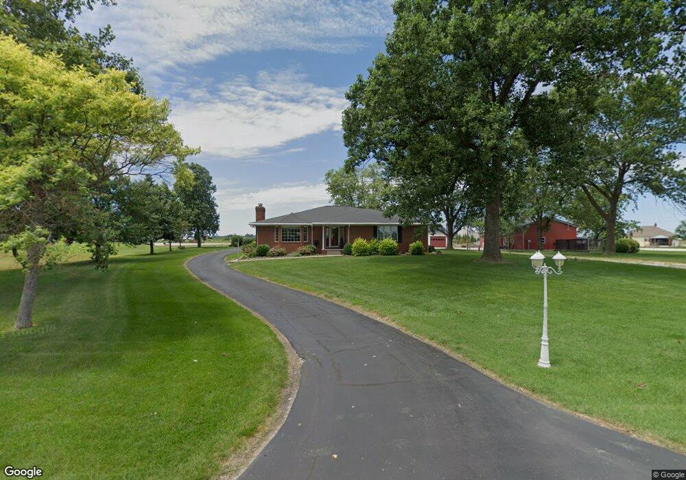
1799 S Stevenson Station Rd Chandler, IN 47610
Estimated Value: $272,000 - $417,000
3
Beds
2
Baths
2,553
Sq Ft
$135/Sq Ft
Est. Value
About This Home
This home is located at 1799 S Stevenson Station Rd, Chandler, IN 47610 and is currently estimated at $344,866, approximately $135 per square foot. 1799 S Stevenson Station Rd is a home located in Warrick County with nearby schools including John H. Castle Elementary School, Castle North Middle School, and Castle High School.
Ownership History
Date
Name
Owned For
Owner Type
Purchase Details
Closed on
Nov 20, 2013
Sold by
Mcguire Randy C and Mcguire Christine K
Bought by
Mcguire Randy C and Mcguire Christine K
Current Estimated Value
Create a Home Valuation Report for This Property
The Home Valuation Report is an in-depth analysis detailing your home's value as well as a comparison with similar homes in the area
Home Values in the Area
Average Home Value in this Area
Purchase History
| Date | Buyer | Sale Price | Title Company |
|---|---|---|---|
| Mcguire Randy C | -- | None Available |
Source: Public Records
Tax History Compared to Growth
Tax History
| Year | Tax Paid | Tax Assessment Tax Assessment Total Assessment is a certain percentage of the fair market value that is determined by local assessors to be the total taxable value of land and additions on the property. | Land | Improvement |
|---|---|---|---|---|
| 2024 | $1,999 | $261,200 | $29,900 | $231,300 |
| 2023 | $2,445 | $282,500 | $29,900 | $252,600 |
| 2022 | $2,501 | $279,600 | $29,900 | $249,700 |
| 2021 | $2,196 | $233,800 | $29,900 | $203,900 |
| 2020 | $2,242 | $231,800 | $18,300 | $213,500 |
| 2019 | $2,255 | $227,000 | $18,300 | $208,700 |
| 2018 | $2,008 | $212,000 | $18,300 | $193,700 |
| 2017 | $2,009 | $212,400 | $18,300 | $194,100 |
| 2016 | $1,957 | $208,400 | $18,300 | $190,100 |
| 2014 | $3,118 | $207,700 | $16,000 | $191,700 |
Source: Public Records
Map
Nearby Homes
- 3142 Helmsford Ct
- 3411 Braewick Dr
- The Calloway Plan at Centerra Ridge
- The Andover Plan at Centerra Ridge
- The Lexington Plan at Centerra Ridge
- The Camelia With Bonus Plan at Centerra Ridge
- The Lyndon Plan at Centerra Ridge
- The Beaumont Plan at Centerra Ridge
- The Fontaine Plan at Centerra Ridge
- The Dresden With Brick Plan at Centerra Ridge
- The Camelia Plan at Centerra Ridge
- The Kendrick Plan at Centerra Ridge
- The Truman Plan at Centerra Ridge
- The Sheffield Plan at Centerra Ridge
- 3515 Ralston Dr
- 3243 Ralston Dr
- 8137 Prescott Dr
- 1148 S Stevenson Station Rd
- 1404 S Stevenson Station Rd
- 1116 S Stevenson Station Rd
- 1776 S Stevenson Station Rd
- 1776 S Stevenson Station Rd
- 1766 S Stevenson Station Rd
- 1744 S Stevenson Station Rd
- 1722 S Stevenson Station Rd
- 1700 S Stevenson Station Rd
- 1688 S Stevenson Station Rd
- 1666 S Stevenson Station Rd
- 1944 S Stevenson Station Rd
- 10277 Telephone Rd
- 10277 Telephone Rd
- 10255 Telephone Rd
- 10433 Telephone Rd
- 1511 S Stevenson Station Rd
- 10500 Telephone Rd
- 1477 S Stevenson Station Rd
- 2100 Epworth Rd
- 2122 Epworth Rd
- 9999 Indiana 62
- 9999 State Route 62 W