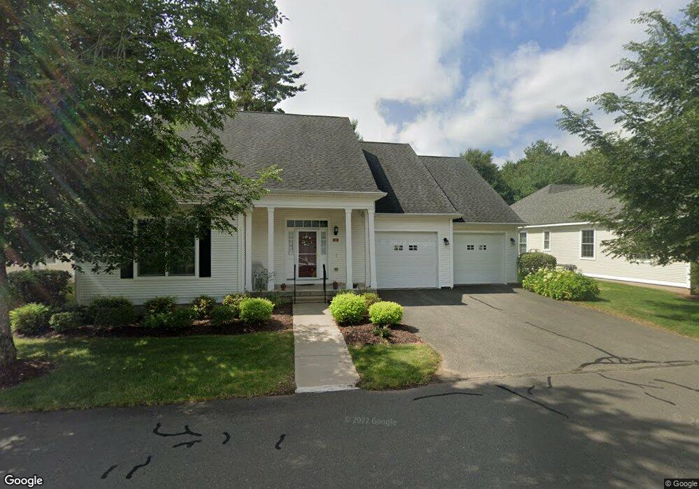
18 Ashton Cir Unit 18 Simsbury, CT 06070
Estimated Value: $562,000 - $691,000
2
Beds
2
Baths
1,809
Sq Ft
$352/Sq Ft
Est. Value
About This Home
This home is located at 18 Ashton Cir Unit 18, Simsbury, CT 06070 and is currently estimated at $637,277, approximately $352 per square foot. 18 Ashton Cir Unit 18 is a home located in Hartford County with nearby schools including Central School, Henry James Memorial School, and Simsbury High School.
Ownership History
Date
Name
Owned For
Owner Type
Purchase Details
Closed on
Sep 2, 2014
Sold by
Skripol Paul G and Stewart Susan L
Bought by
Parasch Frederic A and Parasch Frances B
Current Estimated Value
Home Financials for this Owner
Home Financials are based on the most recent Mortgage that was taken out on this home.
Original Mortgage
$220,000
Outstanding Balance
$168,424
Interest Rate
4.14%
Mortgage Type
New Conventional
Estimated Equity
$468,853
Purchase Details
Closed on
Feb 13, 2012
Sold by
Skipol Mary G
Bought by
Skripol James N and Skripol Paul G
Purchase Details
Closed on
Sep 15, 2006
Sold by
Powder Forest Homes Ll
Bought by
Skripol Mary G
Create a Home Valuation Report for This Property
The Home Valuation Report is an in-depth analysis detailing your home's value as well as a comparison with similar homes in the area
Home Values in the Area
Average Home Value in this Area
Purchase History
| Date | Buyer | Sale Price | Title Company |
|---|---|---|---|
| Parasch Frederic A | $331,000 | -- | |
| Skripol James N | -- | -- | |
| Skripol Mary G | $374,620 | -- |
Source: Public Records
Mortgage History
| Date | Status | Borrower | Loan Amount |
|---|---|---|---|
| Open | Skripol Mary G | $220,000 |
Source: Public Records
Tax History Compared to Growth
Tax History
| Year | Tax Paid | Tax Assessment Tax Assessment Total Assessment is a certain percentage of the fair market value that is determined by local assessors to be the total taxable value of land and additions on the property. | Land | Improvement |
|---|---|---|---|---|
| 2025 | $10,509 | $307,650 | $0 | $307,650 |
| 2024 | $10,248 | $307,650 | $0 | $307,650 |
| 2023 | $9,789 | $307,650 | $0 | $307,650 |
| 2022 | $9,043 | $234,100 | $0 | $234,100 |
| 2021 | $9,043 | $234,100 | $0 | $234,100 |
| 2020 | $8,683 | $234,100 | $0 | $234,100 |
| 2019 | $8,737 | $234,100 | $0 | $234,100 |
| 2018 | $8,800 | $234,100 | $0 | $234,100 |
| 2017 | $10,454 | $269,720 | $0 | $269,720 |
| 2016 | $10,012 | $269,720 | $0 | $269,720 |
| 2015 | $10,012 | $269,720 | $0 | $269,720 |
| 2014 | $10,017 | $269,720 | $0 | $269,720 |
Source: Public Records
Map
Nearby Homes
- 16 Stratton Forest Way
- 3 Stebbins Brook Ln
- 4 Stebbins Brook Ln
- 1 West St Unit 206
- 40 Firetown Rd Unit 39
- 15 Sand Hill Rd
- 47 Long View Dr
- 18 Meadowlark Rd
- 48 Library Ln Unit 48
- 44 Simsbury Manor Dr
- 308 Hopmeadow St
- 301 Bushy Hill Rd
- 3 Cobtail Way
- 9 Cobtail Way
- 25 Barry Ln
- 3 Minister Brook Dr
- 15 Pinnacle Mountain Rd
- 10 Sachems Trail
- 8 Quorn Hunt Rd
- 8 Crane Place
- 18 Ashton Cir
- 20 Ashton Cir
- 20 Ashton Cir Unit 20
- 17 Ashton Cir
- 19 Ashton Cir
- 16 Ashton Cir
- 16 Ashton Cir Unit 16
- 21 Ashton Cir
- 21 Ashton Cir Unit 21
- 22 Ashton Cir
- 15 Ashton Cir
- 15 Ashton Cir Unit 15
- 12 Greenwich Cir
- 12 Greenwich Cir Unit 51
- 14 Ashton Cir
- 14 Ashton Cir Unit 14
- 10 Greenwich Cir
- 13 Ashton Cir
- 8 Greenwich Cir
- 14 Barons Ct