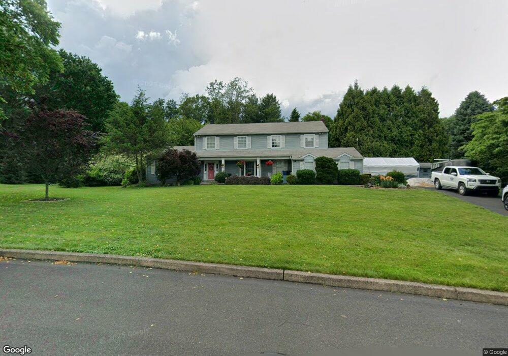
18 Charter Cir Doylestown, PA 18901
Estimated Value: $815,568 - $990,000
4
Beds
3
Baths
3,220
Sq Ft
$287/Sq Ft
Est. Value
About This Home
This home is located at 18 Charter Cir, Doylestown, PA 18901 and is currently estimated at $925,142, approximately $287 per square foot. 18 Charter Cir is a home located in Bucks County with nearby schools including Doyle El School, Lenape Middle School, and Central Bucks High School-West.
Ownership History
Date
Name
Owned For
Owner Type
Purchase Details
Closed on
Jul 30, 2014
Sold by
Flego Louis I and Flego Susan C
Bought by
Flego Glenn S and Flego Family Pa Irrevocable Trust
Current Estimated Value
Purchase Details
Closed on
Jun 26, 1997
Sold by
Devaney David T and Devaney Sharman L
Bought by
Flego Louis I and Flego Susan C
Home Financials for this Owner
Home Financials are based on the most recent Mortgage that was taken out on this home.
Original Mortgage
$240,300
Outstanding Balance
$34,436
Interest Rate
7.5%
Estimated Equity
$890,706
Purchase Details
Closed on
Aug 19, 1993
Sold by
Nowakowski Craig J and Nowakowski Jo Ann
Bought by
Devaney David T and Devaney Sharman L
Home Financials for this Owner
Home Financials are based on the most recent Mortgage that was taken out on this home.
Original Mortgage
$191,000
Interest Rate
7.11%
Create a Home Valuation Report for This Property
The Home Valuation Report is an in-depth analysis detailing your home's value as well as a comparison with similar homes in the area
Home Values in the Area
Average Home Value in this Area
Purchase History
| Date | Buyer | Sale Price | Title Company |
|---|---|---|---|
| Flego Glenn S | -- | None Available | |
| Flego Louis I | $267,000 | -- | |
| Devaney David T | $243,000 | First American Title Ins Co |
Source: Public Records
Mortgage History
| Date | Status | Borrower | Loan Amount |
|---|---|---|---|
| Open | Flego Louis I | $240,300 | |
| Previous Owner | Devaney David T | $191,000 |
Source: Public Records
Tax History
| Year | Tax Paid | Tax Assessment Tax Assessment Total Assessment is a certain percentage of the fair market value that is determined by local assessors to be the total taxable value of land and additions on the property. | Land | Improvement |
|---|---|---|---|---|
| 2025 | $9,216 | $52,080 | $9,240 | $42,840 |
| 2024 | $9,216 | $52,080 | $9,240 | $42,840 |
| 2023 | $8,788 | $52,080 | $9,240 | $42,840 |
| 2022 | $8,690 | $52,080 | $9,240 | $42,840 |
| 2021 | $8,511 | $52,080 | $9,240 | $42,840 |
| 2020 | $8,472 | $52,080 | $9,240 | $42,840 |
| 2019 | $8,381 | $52,080 | $9,240 | $42,840 |
| 2018 | $8,355 | $52,080 | $9,240 | $42,840 |
| 2017 | $8,290 | $52,080 | $9,240 | $42,840 |
| 2016 | $8,238 | $52,080 | $9,240 | $42,840 |
| 2015 | -- | $52,080 | $9,240 | $42,840 |
| 2014 | -- | $52,080 | $9,240 | $42,840 |
Source: Public Records
Map
Nearby Homes
- 807 N Broad St
- 117 Cottonwood Ct
- 4 Windey Way Ln
- 4570 Louise Saint Claire Dr
- 3622 Alley E
- 21 Washington Square Unit 36
- 3688 Christopher Day Rd
- 225 Chestnut Valley Dr
- 12 Pine Valley Rd
- 209 Harvey Ave
- 94 Chestnut Valley Dr
- 102 Clear Springs Ct
- 215 N Franklin St
- 180 N Clinton St
- 333 Lacey Ave Unit B9
- 169 N Main St
- 3910 Cephas Child Rd Unit 6
- 150 Selner Ln
- 61 N Hamilton St
- 190 Decatur St
- 16 Charter Cir
- 20 Charter Cir
- 216 Larch Cir
- 8 Charter Cir
- 218 Larch Cir
- 22 Charter Cir
- 214 Larch Cir
- 6 Settlers Dr
- 220 Sandy Knoll Dr
- 10 Charter Cir
- 14 Charter Cir
- 24 Settlers Dr
- 106 Sandy Knoll Cir
- 12 Charter Cir
- 212 Larch Cir
- 26 Settlers Dr
- 228 Sandy Knoll Dr
- 4 Settlers Dr
- 210 Larch Cir
- 110 Sandy Knoll Cir
Your Personal Tour Guide
Ask me questions while you tour the home.