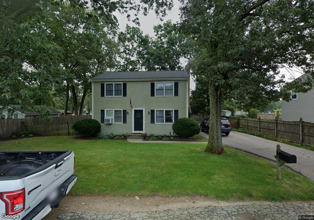
18 Cypress Rd Wrentham, MA 02093
Estimated Value: $496,000 - $610,000
3
Beds
3
Baths
1,440
Sq Ft
$384/Sq Ft
Est. Value
About This Home
This home is located at 18 Cypress Rd, Wrentham, MA 02093 and is currently estimated at $553,515, approximately $384 per square foot. 18 Cypress Rd is a home located in Norfolk County with nearby schools including Delaney Elementary School, Charles E Roderick, and The Sage School.
Ownership History
Date
Name
Owned For
Owner Type
Purchase Details
Closed on
Dec 8, 1994
Sold by
Seventh Rlty Corp
Bought by
Giosi Mark J
Current Estimated Value
Home Financials for this Owner
Home Financials are based on the most recent Mortgage that was taken out on this home.
Original Mortgage
$134,100
Interest Rate
9%
Mortgage Type
Purchase Money Mortgage
Purchase Details
Closed on
Sep 19, 1994
Sold by
Estano Phyllis V
Bought by
Seventh Rlty Corp
Create a Home Valuation Report for This Property
The Home Valuation Report is an in-depth analysis detailing your home's value as well as a comparison with similar homes in the area
Home Values in the Area
Average Home Value in this Area
Purchase History
| Date | Buyer | Sale Price | Title Company |
|---|---|---|---|
| Giosi Mark J | $149,000 | -- | |
| Seventh Rlty Corp | $26,000 | -- |
Source: Public Records
Mortgage History
| Date | Status | Borrower | Loan Amount |
|---|---|---|---|
| Closed | Giosi Mark J | $134,100 |
Source: Public Records
Tax History Compared to Growth
Tax History
| Year | Tax Paid | Tax Assessment Tax Assessment Total Assessment is a certain percentage of the fair market value that is determined by local assessors to be the total taxable value of land and additions on the property. | Land | Improvement |
|---|---|---|---|---|
| 2025 | $5,594 | $482,700 | $220,300 | $262,400 |
| 2024 | $5,428 | $452,300 | $220,300 | $232,000 |
| 2023 | $5,024 | $398,100 | $200,300 | $197,800 |
| 2022 | $4,955 | $362,500 | $194,900 | $167,600 |
| 2021 | $4,739 | $336,800 | $182,100 | $154,700 |
| 2020 | $4,385 | $307,700 | $139,000 | $168,700 |
| 2019 | $4,044 | $286,400 | $125,100 | $161,300 |
| 2018 | $3,952 | $277,500 | $125,600 | $151,900 |
| 2017 | $3,719 | $261,000 | $123,200 | $137,800 |
| 2016 | $3,639 | $254,800 | $119,600 | $135,200 |
| 2015 | $3,720 | $248,300 | $127,800 | $120,500 |
| 2014 | $3,659 | $239,000 | $122,900 | $116,100 |
Source: Public Records
Map
Nearby Homes
- 246 Forest Grove Ave
- 3 Oak Rd
- 0 W Birch Rd
- 10 W Birch Rd
- 270 Dedham St
- 45 King St
- 45 Joshua Rd
- 1 Lorraine Metcalf Dr
- 3 Sparrow Rd
- 38 Robin Rd
- 50 Reed Fulton Ave Unit Lot 61
- 11 Quail Run Rd
- 10 Nature View Dr
- 15 Nature View Dr
- 2 Diamond St
- 3 Pheasanthill Rd
- 570 Franklin St
- 71 Pond St
- 14 Essex St
- 362 East St