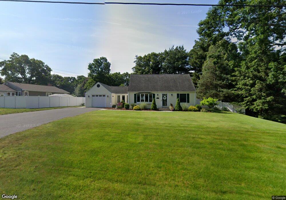
18 Decorie Dr Wilbraham, MA 01095
Estimated Value: $417,454 - $505,000
4
Beds
2
Baths
1,734
Sq Ft
$264/Sq Ft
Est. Value
About This Home
This home is located at 18 Decorie Dr, Wilbraham, MA 01095 and is currently estimated at $457,364, approximately $263 per square foot. 18 Decorie Dr is a home located in Hampden County with nearby schools including Minnechaug Regional High School, Springfield International Charter School, and Wilbraham & Monson Academy.
Ownership History
Date
Name
Owned For
Owner Type
Purchase Details
Closed on
Apr 30, 2002
Sold by
Rubin Robert C
Bought by
Tranghese Joseph M and Tranghese Charlene M
Current Estimated Value
Home Financials for this Owner
Home Financials are based on the most recent Mortgage that was taken out on this home.
Original Mortgage
$155,000
Interest Rate
7.05%
Mortgage Type
Purchase Money Mortgage
Purchase Details
Closed on
Jul 2, 1999
Sold by
Wong Steve W and Kan Alice C
Bought by
Rubin Robert C
Home Financials for this Owner
Home Financials are based on the most recent Mortgage that was taken out on this home.
Original Mortgage
$86,000
Interest Rate
7.19%
Mortgage Type
Purchase Money Mortgage
Purchase Details
Closed on
Jan 24, 1989
Sold by
Magill Dorothy C
Bought by
Wong Steven W
Create a Home Valuation Report for This Property
The Home Valuation Report is an in-depth analysis detailing your home's value as well as a comparison with similar homes in the area
Home Values in the Area
Average Home Value in this Area
Purchase History
| Date | Buyer | Sale Price | Title Company |
|---|---|---|---|
| Tranghese Joseph M | $195,000 | -- | |
| Rubin Robert C | $132,500 | -- | |
| Wong Steven W | $136,000 | -- |
Source: Public Records
Mortgage History
| Date | Status | Borrower | Loan Amount |
|---|---|---|---|
| Open | Wong Steven W | $210,000 | |
| Closed | Wong Steven W | $155,000 | |
| Previous Owner | Wong Steven W | $86,000 |
Source: Public Records
Tax History
| Year | Tax Paid | Tax Assessment Tax Assessment Total Assessment is a certain percentage of the fair market value that is determined by local assessors to be the total taxable value of land and additions on the property. | Land | Improvement |
|---|---|---|---|---|
| 2025 | $6,203 | $346,900 | $96,800 | $250,100 |
| 2024 | $6,014 | $325,100 | $96,800 | $228,300 |
| 2023 | $6,043 | $305,600 | $96,800 | $208,800 |
| 2022 | $6,043 | $294,900 | $96,800 | $198,100 |
| 2021 | $5,770 | $251,300 | $104,400 | $146,900 |
| 2020 | $5,624 | $251,300 | $104,400 | $146,900 |
| 2019 | $5,478 | $251,300 | $104,400 | $146,900 |
| 2018 | $5,305 | $234,300 | $104,400 | $129,900 |
| 2017 | $5,155 | $234,300 | $104,400 | $129,900 |
| 2016 | $5,046 | $233,600 | $115,800 | $117,800 |
| 2015 | $4,878 | $233,600 | $115,800 | $117,800 |
Source: Public Records
Map
Nearby Homes
- 104 High Pine Cir
- 8 Patriot Ridge Ln
- 8 High Pine Cir
- 172 Main St
- 20 Old Orchard Rd
- 1 Aspen Dr
- 35 Lake Dr
- 46 Washington Rd
- 474 Mountain Rd
- 6 Teak Terrace Unit 24
- 474-480 Mountain Rd
- 592 Stony Hill Rd
- 103 Sandalwood Dr Unit site 00
- 6 Hilltop Park
- 57 Sandalwood Dr Unit site 61
- 84 Sandalwood Dr Unit site 00
- 3 Mohawk St
- 26 Sandalwood Dr
- 36 Maple St
- 15 Cedar Ridge Dr Unit 1
Your Personal Tour Guide
Ask me questions while you tour the home.