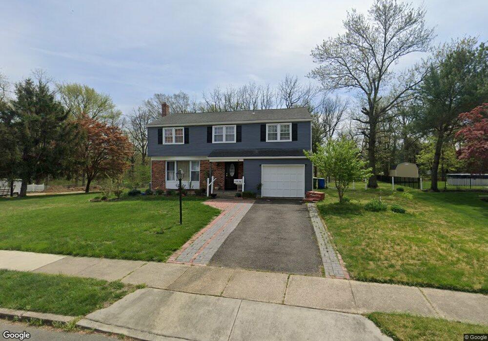
18 Flintstone Dr Marlton, NJ 08053
Estimated Value: $452,701 - $570,000
--
Bed
--
Bath
1,940
Sq Ft
$261/Sq Ft
Est. Value
About This Home
This home is located at 18 Flintstone Dr, Marlton, NJ 08053 and is currently estimated at $506,675, approximately $261 per square foot. 18 Flintstone Dr is a home located in Burlington County with nearby schools including Marlton Middle School, Cherokee High School, and Lenape High School.
Ownership History
Date
Name
Owned For
Owner Type
Purchase Details
Closed on
Dec 3, 2019
Sold by
Phh Mortgage Corporation
Bought by
Ashraf Sohail and Altaf Mohammad
Current Estimated Value
Purchase Details
Closed on
May 28, 2019
Sold by
Mcdonald Colleen P and Ocwen Loan Servicing Llc
Bought by
Phh Mortgage Corporation
Purchase Details
Closed on
May 4, 1998
Sold by
Beer Brian R
Bought by
Mcdonald Colleen P
Purchase Details
Closed on
May 3, 1995
Sold by
Kane Jeff A and Kane Priscilla A
Bought by
Mcdonald Colleen P
Create a Home Valuation Report for This Property
The Home Valuation Report is an in-depth analysis detailing your home's value as well as a comparison with similar homes in the area
Home Values in the Area
Average Home Value in this Area
Purchase History
| Date | Buyer | Sale Price | Title Company |
|---|---|---|---|
| Ashraf Sohail | $207,500 | Servicelink Ttl Co Default T | |
| Phh Mortgage Corporation | -- | None Available | |
| Mcdonald Colleen P | -- | -- | |
| Mcdonald Colleen P | $143,900 | -- |
Source: Public Records
Tax History Compared to Growth
Tax History
| Year | Tax Paid | Tax Assessment Tax Assessment Total Assessment is a certain percentage of the fair market value that is determined by local assessors to be the total taxable value of land and additions on the property. | Land | Improvement |
|---|---|---|---|---|
| 2025 | $8,384 | $245,500 | $90,000 | $155,500 |
| 2024 | $7,888 | $245,500 | $90,000 | $155,500 |
| 2023 | $7,888 | $245,500 | $90,000 | $155,500 |
| 2022 | $7,534 | $245,500 | $90,000 | $155,500 |
| 2021 | $7,358 | $245,500 | $90,000 | $155,500 |
| 2020 | $7,262 | $245,500 | $90,000 | $155,500 |
| 2019 | $7,203 | $245,500 | $90,000 | $155,500 |
| 2018 | $7,102 | $245,500 | $90,000 | $155,500 |
| 2017 | $7,019 | $245,500 | $90,000 | $155,500 |
| 2016 | $6,847 | $245,500 | $90,000 | $155,500 |
| 2015 | $6,727 | $245,500 | $90,000 | $155,500 |
| 2014 | $6,535 | $245,500 | $90,000 | $155,500 |
Source: Public Records
Map
Nearby Homes
- 31 Flintstone Dr
- 61 S Maple Ave
- 42 S Locust Ave
- 1 Sunnyside Ct
- 30 Cooper Ave
- 22 Bettlewood Rd
- 35 Euston Rd W
- 20 Marlborough Ave
- 17 Erindale Dr
- 29 Marlborough Ave
- 7 Quaker St
- 100 Cambridge Ave
- 400 E Main St
- 625 Route 73 S
- 118 Cambridge Ave
- 22 Hawk Ln
- 4 Brower Ct
- 63 Banner Ct Unit 63
- 2 Split Rail Ln
- 38 Ashley Ct Unit 38
- 16 Flintstone Dr
- 14 Flintstone Dr
- 15 Flintstone Dr
- 20 Flintstone Dr
- 12 Flintstone Dr
- 13 Flintstone Dr
- 21 Flintstone Dr
- 22 Flintstone Dr
- 20 Arrowhead Dr
- 10 Flintstone Dr
- 11 Flintstone Dr
- 24 Flintstone Dr
- 18 Arrowhead Dr
- 23 Arrowhead Dr
- 23 Flintstone Dr
- 8 Flintstone Dr
- 9 Flintstone Dr
- 69 S Locust Ave
- 26 Flintstone Dr
- 16 Arrowhead Dr