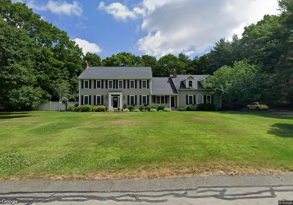
18 Holly Tree Dr Kingston, MA 02364
Estimated Value: $940,000 - $1,123,840
4
Beds
3
Baths
3,899
Sq Ft
$263/Sq Ft
Est. Value
About This Home
This home is located at 18 Holly Tree Dr, Kingston, MA 02364 and is currently estimated at $1,027,210, approximately $263 per square foot. 18 Holly Tree Dr is a home located in Plymouth County with nearby schools including Kingston Elementary School, Silver Lake Regional High School, and Kingston Intermediate School.
Ownership History
Date
Name
Owned For
Owner Type
Purchase Details
Closed on
Aug 30, 2016
Sold by
Cannon Robert T
Bought by
Papile Anthony R and Papile Megna K
Current Estimated Value
Home Financials for this Owner
Home Financials are based on the most recent Mortgage that was taken out on this home.
Original Mortgage
$492,000
Outstanding Balance
$392,864
Interest Rate
3.42%
Mortgage Type
New Conventional
Estimated Equity
$634,346
Purchase Details
Closed on
Jan 31, 1992
Sold by
Indian Pond Assocs Inc
Bought by
Cannon Robert T and Cannon Mary L
Create a Home Valuation Report for This Property
The Home Valuation Report is an in-depth analysis detailing your home's value as well as a comparison with similar homes in the area
Home Values in the Area
Average Home Value in this Area
Purchase History
| Date | Buyer | Sale Price | Title Company |
|---|---|---|---|
| Papile Anthony R | $615,000 | -- | |
| Cannon Robert T | $302,000 | -- |
Source: Public Records
Mortgage History
| Date | Status | Borrower | Loan Amount |
|---|---|---|---|
| Open | Papile Anthony R | $492,000 | |
| Previous Owner | Cannon Robert T | $285,000 | |
| Previous Owner | Cannon Robert T | $285,000 |
Source: Public Records
Tax History Compared to Growth
Tax History
| Year | Tax Paid | Tax Assessment Tax Assessment Total Assessment is a certain percentage of the fair market value that is determined by local assessors to be the total taxable value of land and additions on the property. | Land | Improvement |
|---|---|---|---|---|
| 2025 | $12,091 | $932,200 | $236,600 | $695,600 |
| 2024 | $11,037 | $868,400 | $236,600 | $631,800 |
| 2023 | $10,486 | $784,900 | $236,600 | $548,300 |
| 2022 | $10,129 | $694,700 | $215,100 | $479,600 |
| 2021 | $10,729 | $667,200 | $215,100 | $452,100 |
| 2020 | $10,595 | $650,800 | $215,100 | $435,700 |
| 2019 | $5,100 | $637,700 | $223,800 | $413,900 |
| 2018 | $9,738 | $592,000 | $227,200 | $364,800 |
| 2017 | $9,753 | $591,100 | $217,200 | $373,900 |
| 2016 | $9,203 | $522,600 | $198,800 | $323,800 |
| 2015 | $8,946 | $528,100 | $198,800 | $329,300 |
| 2014 | $8,238 | $493,900 | $201,800 | $292,100 |
Source: Public Records
Map
Nearby Homes
- 41 High Pines Dr
- 7 Hemlock St
- 2 Continental Ct
- 420 Elm St
- 294 Country Club Way
- 39 South St
- 34 Fairway Dr
- 484 Country Club Way
- 91 Monks Hill Rd
- 16 Copper Beech Dr Marion Dr
- 25 Nelson St
- 14 Wapping Rd
- 228 Main St
- 79 Wapping Rd
- 3 Alec Ln
- 83 Wapping Rd
- 97 Wapping Rd
- 26 Brookings Dr
- 200 Plympton Rd
- 231 Main St
- 26 Holly Tree Dr
- 10 Holly Tree Dr
- 19 Holly Tree Dr
- 49 High Pines Dr
- 33 High Pines Dr
- 11 Holly Tree Dr
- 27 Holly Tree Dr
- 4 Holly Tree Dr
- 97 Wolf Pond Rd
- 18 Juniper Dr
- 101 Wolf Pond Rd
- 16 Fox Den Rd
- 48 High Pines Dr
- 10 Juniper Dr
- 25 High Pines Dr
- 93 Wolf Pond Rd
- 40 High Pines Dr
- 30 Juniper Dr
- 24 Fox Den Rd
- 6 Mulberry Dr