


PENDING
$85K PRICE DROP
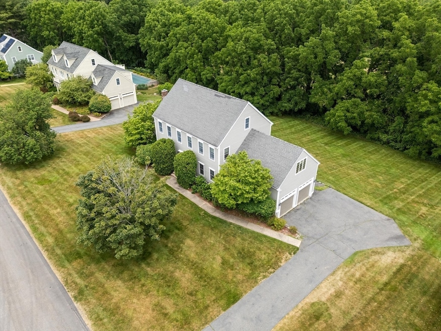
18 Jacob Amsden Rd Westborough, MA 01581
Estimated payment $7,890/month
Total Views
20,471
4
Beds
2.5
Baths
4,502
Sq Ft
$267
Price per Sq Ft
Highlights
- Colonial Architecture
- Deck
- Wood Flooring
- Westborough High School Rated A+
- Vaulted Ceiling
- Attic
About This Home
Set in a premier neighborhood, this exceptional home features a chef’s dream kitchen with a Wolf industrial-grade stove, two double dishwashers, a Sub-Zero refrigerator, an Electrolux convection oven and a wine/beverage refrigerator. Entertain effortlessly in the formal living room or unwind by the fireplace in the inviting family room, which opens to an oversized deck overlooking a lush, landscaped yard. The first-floor office with built-in shelves offers an inspiring workspace. Upstairs, you’ll find four spacious bedrooms including a serene primary suite with a private sitting room. A walk-up attic provides exciting potential for future expansion, while a finished walkout lower level completes this one-of-a-kind home.
Home Details
Home Type
- Single Family
Est. Annual Taxes
- $16,370
Year Built
- Built in 1992
Lot Details
- 0.71 Acre Lot
- Gentle Sloping Lot
Parking
- 2 Car Attached Garage
- Driveway
- Open Parking
Home Design
- Colonial Architecture
- Frame Construction
- Shingle Roof
- Concrete Perimeter Foundation
Interior Spaces
- Wet Bar
- Vaulted Ceiling
- French Doors
- Family Room with Fireplace
- Sitting Room
- Home Office
- Bonus Room
- Play Room
- Home Gym
- Attic
Kitchen
- Breakfast Bar
- Oven
- Range
- Dishwasher
- Kitchen Island
- Solid Surface Countertops
- Disposal
Flooring
- Wood
- Wall to Wall Carpet
- Laminate
- Ceramic Tile
- Vinyl
Bedrooms and Bathrooms
- 4 Bedrooms
- Primary bedroom located on second floor
- Cedar Closet
- Dual Vanity Sinks in Primary Bathroom
- Bathtub with Shower
Laundry
- Dryer
- Washer
Finished Basement
- Walk-Out Basement
- Basement Fills Entire Space Under The House
- Laundry in Basement
Outdoor Features
- Deck
Schools
- Hastings Elementary School
- Gibbons Middle School
- Westborough High School
Utilities
- Forced Air Heating and Cooling System
- Heating System Uses Natural Gas
- 200+ Amp Service
Community Details
- No Home Owners Association
Listing and Financial Details
- Assessor Parcel Number M:0039 B:000152 L:0,1737498
Map
Create a Home Valuation Report for This Property
The Home Valuation Report is an in-depth analysis detailing your home's value as well as a comparison with similar homes in the area
Home Values in the Area
Average Home Value in this Area
Tax History
| Year | Tax Paid | Tax Assessment Tax Assessment Total Assessment is a certain percentage of the fair market value that is determined by local assessors to be the total taxable value of land and additions on the property. | Land | Improvement |
|---|---|---|---|---|
| 2025 | $16,370 | $1,004,900 | $364,000 | $640,900 |
| 2024 | $15,608 | $951,100 | $346,500 | $604,600 |
| 2023 | $14,506 | $861,400 | $326,800 | $534,600 |
| 2022 | $13,457 | $727,800 | $260,100 | $467,700 |
| 2021 | $13,302 | $717,500 | $249,800 | $467,700 |
| 2020 | $13,194 | $720,200 | $264,400 | $455,800 |
| 2019 | $13,212 | $720,800 | $260,200 | $460,600 |
| 2018 | $12,267 | $664,500 | $249,800 | $414,700 |
| 2017 | $11,828 | $664,500 | $249,800 | $414,700 |
| 2016 | $11,881 | $668,600 | $249,800 | $418,800 |
| 2015 | $11,373 | $611,800 | $220,700 | $391,100 |
Source: Public Records
Property History
| Date | Event | Price | Change | Sq Ft Price |
|---|---|---|---|---|
| 08/14/2025 08/14/25 | Pending | -- | -- | -- |
| 08/08/2025 08/08/25 | Price Changed | $1,200,000 | -6.6% | $267 / Sq Ft |
| 07/10/2025 07/10/25 | For Sale | $1,285,000 | -- | $285 / Sq Ft |
Source: MLS Property Information Network (MLS PIN)
Purchase History
| Date | Type | Sale Price | Title Company |
|---|---|---|---|
| Deed | $440,500 | -- | |
| Deed | $371,000 | -- | |
| Deed | $344,500 | -- |
Source: Public Records
Mortgage History
| Date | Status | Loan Amount | Loan Type |
|---|---|---|---|
| Open | $333,700 | No Value Available | |
| Closed | $320,000 | No Value Available | |
| Closed | $300,000 | No Value Available | |
| Closed | $374,425 | Purchase Money Mortgage |
Source: Public Records
Similar Homes in the area
Source: MLS Property Information Network (MLS PIN)
MLS Number: 73402367
APN: WBOR-000039-000152
Disclaimer: Certain information contained herein is derived from information provided by parties other than Homes.com. All information provided is deemed reliable, but is not guaranteed to be accurate and should be independently verified.
![]() The property listing data and information, or the Images, set forth herein were provided to MLS Property Information Network, Inc. from third party sources, including sellers, lessors and public records, and were compiled by MLS Property Information Network, Inc. The property listing data and information, and the Images, are for the personal, non-commercial use of consumers having a good faith interest in purchasing or leasing listed properties of the type displayed to them and may not be used for any purpose other than to identify prospective properties which such consumers may have a good faith interest in purchasing or leasing. MLS Property Information Network, Inc. and its subscribers disclaim any and all representations and warranties as to the accuracy of the property listing data and information, or as to the accuracy of any of the Images, set forth herein.
The property listing data and information, or the Images, set forth herein were provided to MLS Property Information Network, Inc. from third party sources, including sellers, lessors and public records, and were compiled by MLS Property Information Network, Inc. The property listing data and information, and the Images, are for the personal, non-commercial use of consumers having a good faith interest in purchasing or leasing listed properties of the type displayed to them and may not be used for any purpose other than to identify prospective properties which such consumers may have a good faith interest in purchasing or leasing. MLS Property Information Network, Inc. and its subscribers disclaim any and all representations and warranties as to the accuracy of the property listing data and information, or as to the accuracy of any of the Images, set forth herein.
Nearby Homes
- 191 E Main St
- 18 Crestview Dr
- 30 Haskell St
- 22 High St
- 14 High St
- 38 Haskell St
- 28 Granuaile Rd
- 135 E Main St Unit K-12
- 11312 Peters Farm Way Unit 11312
- 3103 Peters Farm Way Unit 3103
- 3102 Peters Farm Way Unit 102
- Ivywood Plan at Chauncy Lake
- Lincoln Plan at Chauncy Lake
- Hayden Plan at Chauncy Lake
- Claremont Plan at Chauncy Lake
- Magnolia Plan at Chauncy Lake
- Jameson Plan at Chauncy Lake
- 12112 Peters Farm Way Unit 12112
- 2 David Henry Gardner Ln
- 12302 Peters Farm Way Unit 302