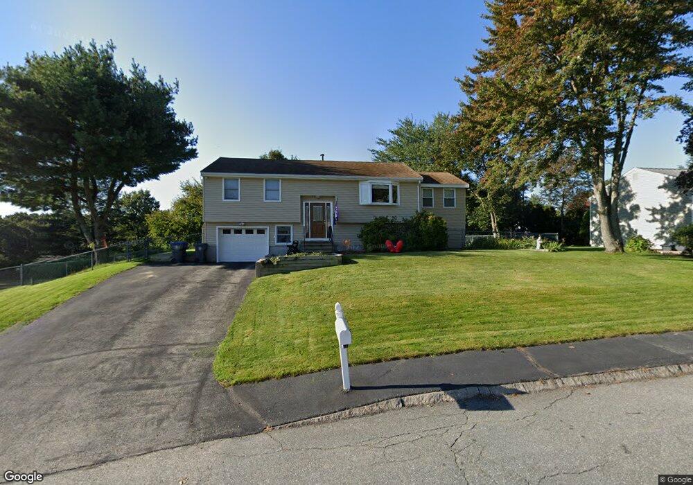
18 Jayson Rd Methuen, MA 01844
The East End NeighborhoodEstimated Value: $591,629 - $636,000
3
Beds
2
Baths
1,092
Sq Ft
$564/Sq Ft
Est. Value
About This Home
This home is located at 18 Jayson Rd, Methuen, MA 01844 and is currently estimated at $615,657, approximately $563 per square foot. 18 Jayson Rd is a home located in Essex County with nearby schools including Timony Grammar School, Methuen High School, and Community Day Charter Public School - Gateway.
Ownership History
Date
Name
Owned For
Owner Type
Purchase Details
Closed on
Sep 12, 2025
Sold by
Renken John D
Bought by
Keep The Faith Irt and Renken
Current Estimated Value
Purchase Details
Closed on
Feb 29, 1996
Sold by
Garson John G
Bought by
Renken John
Home Financials for this Owner
Home Financials are based on the most recent Mortgage that was taken out on this home.
Original Mortgage
$92,400
Interest Rate
7.02%
Mortgage Type
Purchase Money Mortgage
Create a Home Valuation Report for This Property
The Home Valuation Report is an in-depth analysis detailing your home's value as well as a comparison with similar homes in the area
Home Values in the Area
Average Home Value in this Area
Purchase History
| Date | Buyer | Sale Price | Title Company |
|---|---|---|---|
| Keep The Faith Irt | -- | -- | |
| Renken John | $115,500 | -- | |
| Renken John | $115,500 | -- |
Source: Public Records
Mortgage History
| Date | Status | Borrower | Loan Amount |
|---|---|---|---|
| Previous Owner | Renken John | $92,400 |
Source: Public Records
Tax History
| Year | Tax Paid | Tax Assessment Tax Assessment Total Assessment is a certain percentage of the fair market value that is determined by local assessors to be the total taxable value of land and additions on the property. | Land | Improvement |
|---|---|---|---|---|
| 2025 | $5,668 | $535,700 | $211,800 | $323,900 |
| 2024 | $5,700 | $524,900 | $193,200 | $331,700 |
| 2023 | $5,369 | $458,900 | $171,800 | $287,100 |
| 2022 | $5,172 | $396,300 | $143,100 | $253,200 |
| 2021 | $4,909 | $372,200 | $136,000 | $236,200 |
| 2020 | $4,865 | $362,000 | $136,000 | $226,000 |
| 2019 | $4,605 | $324,500 | $121,700 | $202,800 |
| 2018 | $4,432 | $310,600 | $121,700 | $188,900 |
| 2017 | $4,246 | $289,800 | $121,700 | $168,100 |
| 2016 | $4,083 | $275,700 | $114,500 | $161,200 |
| 2015 | $3,932 | $269,300 | $114,500 | $154,800 |
Source: Public Records
Map
Nearby Homes
- 1 Riverview Blvd Unit 8-203
- 32 Josephine Ave
- 68 Ashford St
- 18 Erhardt Terrace
- 7 Erhardt Terrace
- 264 E Haverhill St Unit 2
- 106 Leroy Ave
- 12 Annette St
- 60 Ames St
- 39 Swan Ave
- 2 Leslie St
- 30 Anderson Dr
- 14 Court St
- 65 Arthur St
- 5 Pilgrim Cir Unit C
- 16 Christopher Dr Unit 38
- 45 Christopher Dr Unit 106
- 0 Great Pond Rd
- 27 Woodland Ct
- 37 Albion St
Your Personal Tour Guide
Ask me questions while you tour the home.