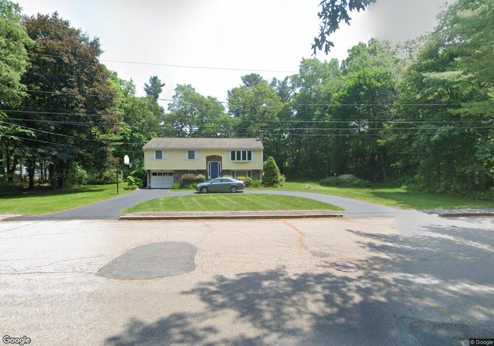
18 Kingsbrook Way North Easton, MA 02356
Estimated Value: $586,000 - $747,000
3
Beds
2
Baths
1,440
Sq Ft
$463/Sq Ft
Est. Value
About This Home
This home is located at 18 Kingsbrook Way, North Easton, MA 02356 and is currently estimated at $667,300, approximately $463 per square foot. 18 Kingsbrook Way is a home located in Bristol County with nearby schools including Easton Middle School.
Ownership History
Date
Name
Owned For
Owner Type
Purchase Details
Closed on
Aug 19, 2014
Sold by
Haimson Barry R and Haimson Anita F
Bought by
Haimson Ft and Haimson
Current Estimated Value
Purchase Details
Closed on
Nov 29, 1972
Bought by
Haimson Jennifer R and Haimson Craig R
Create a Home Valuation Report for This Property
The Home Valuation Report is an in-depth analysis detailing your home's value as well as a comparison with similar homes in the area
Home Values in the Area
Average Home Value in this Area
Purchase History
| Date | Buyer | Sale Price | Title Company |
|---|---|---|---|
| Haimson Ft | -- | -- | |
| Haimson Ft | -- | -- | |
| Haimson Jennifer R | -- | -- |
Source: Public Records
Mortgage History
| Date | Status | Borrower | Loan Amount |
|---|---|---|---|
| Previous Owner | Haimson Jennifer R | $97,000 | |
| Previous Owner | Haimson Jennifer R | $100,000 | |
| Previous Owner | Haimson Jennifer R | $50,000 |
Source: Public Records
Tax History Compared to Growth
Tax History
| Year | Tax Paid | Tax Assessment Tax Assessment Total Assessment is a certain percentage of the fair market value that is determined by local assessors to be the total taxable value of land and additions on the property. | Land | Improvement |
|---|---|---|---|---|
| 2025 | $7,534 | $603,700 | $409,000 | $194,700 |
| 2024 | $6,939 | $519,800 | $325,100 | $194,700 |
| 2023 | $6,983 | $478,600 | $316,500 | $162,100 |
| 2022 | $6,639 | $431,400 | $274,800 | $156,600 |
| 2021 | $6,458 | $417,200 | $260,600 | $156,600 |
| 2020 | $6,321 | $411,000 | $255,800 | $155,200 |
| 2019 | $5,926 | $371,300 | $239,100 | $132,200 |
| 2018 | $5,815 | $358,700 | $239,100 | $119,600 |
| 2017 | $5,636 | $347,500 | $239,100 | $108,400 |
| 2016 | $5,519 | $340,900 | $239,100 | $101,800 |
| 2015 | $5,110 | $304,500 | $202,700 | $101,800 |
| 2014 | $4,978 | $299,000 | $202,700 | $96,300 |
Source: Public Records
Map
Nearby Homes
- 6 Kingsley Rd
- 37 Kingsley Rd
- 15 Randall Farm Dr
- 45 Randall St
- 79 Summer St
- 73 Summer St
- 98 Massapoag Ave
- 29 Owl Ridge Rd
- 9 Oak Ridge Dr
- 30 King Arthur Rd
- 1 Whittier Ln Unit 1
- 18 Prudence Crandall Ln Unit 18
- 10 Matthew Cir
- 218 Massapoag Ave
- 32 Spooner St
- 17 Gaslight Ln
- 1 Newell Cir
- 555 Foundry St Unit B
- 221 Center St
- 531 Foundry St Unit E