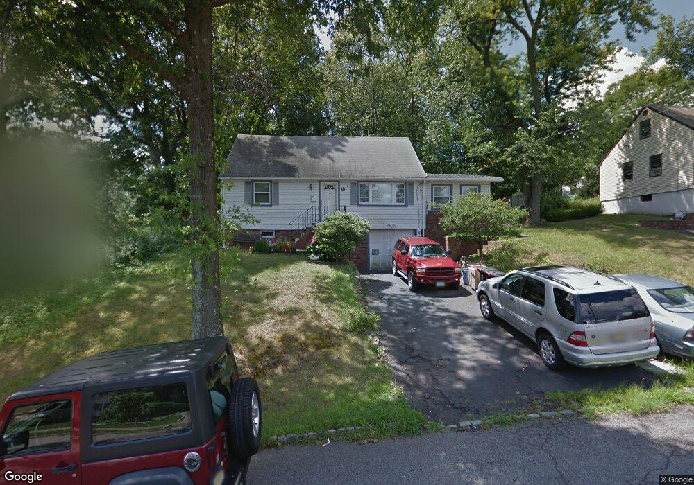
18 Lorelei Rd West Orange, NJ 07052
Estimated Value: $578,450 - $720,000
Studio
--
Bath
1,488
Sq Ft
$436/Sq Ft
Est. Value
About This Home
This home is located at 18 Lorelei Rd, West Orange, NJ 07052 and is currently estimated at $648,113, approximately $435 per square foot. 18 Lorelei Rd is a home located in Essex County with nearby schools including West Orange High School, Golda Och Academy, and Golda Och Academy Lower School.
Ownership History
Date
Name
Owned For
Owner Type
Purchase Details
Closed on
Jun 25, 2024
Sold by
Essex County Sheriff
Bought by
Community Dream Living and Wells Fargo Bank Na
Current Estimated Value
Purchase Details
Closed on
Apr 27, 2001
Sold by
Pallathumadom Matthew C
Bought by
Honorio Charles G and Dupuis Anthony
Home Financials for this Owner
Home Financials are based on the most recent Mortgage that was taken out on this home.
Original Mortgage
$225,600
Interest Rate
7.03%
Mortgage Type
FHA
Purchase Details
Closed on
Aug 8, 1990
Sold by
Gruber Charles and Gruber Joan
Bought by
Pallatumadom Matthew and Pallatumadom Fancimol
Create a Home Valuation Report for This Property
The Home Valuation Report is an in-depth analysis detailing your home's value as well as a comparison with similar homes in the area
Home Values in the Area
Average Home Value in this Area
Purchase History
| Date | Buyer | Sale Price | Title Company |
|---|---|---|---|
| Community Dream Living | $224,152 | Lawyers Title | |
| Honorio Charles G | $234,000 | -- | |
| Pallatumadom Matthew | $165,000 | -- |
Source: Public Records
Mortgage History
| Date | Status | Borrower | Loan Amount |
|---|---|---|---|
| Previous Owner | Honorio Charles G | $225,600 |
Source: Public Records
Tax History
| Year | Tax Paid | Tax Assessment Tax Assessment Total Assessment is a certain percentage of the fair market value that is determined by local assessors to be the total taxable value of land and additions on the property. | Land | Improvement |
|---|---|---|---|---|
| 2025 | $11,697 | $515,700 | $246,600 | $269,100 |
| 2024 | $11,697 | $254,400 | $146,600 | $107,800 |
| 2023 | $11,288 | $254,400 | $146,600 | $107,800 |
| 2022 | $11,288 | $254,400 | $146,600 | $107,800 |
| 2021 | $11,077 | $254,400 | $146,600 | $107,800 |
| 2020 | $10,899 | $254,400 | $146,600 | $107,800 |
| 2019 | $10,586 | $254,400 | $146,600 | $107,800 |
| 2018 | $10,273 | $254,400 | $146,600 | $107,800 |
| 2017 | $10,140 | $254,400 | $146,600 | $107,800 |
| 2016 | $9,896 | $254,400 | $146,600 | $107,800 |
| 2015 | $9,710 | $254,400 | $146,600 | $107,800 |
| 2014 | $9,520 | $254,400 | $146,600 | $107,800 |
Source: Public Records
Map
Nearby Homes
- 33 Mcguire Dr
- 25 Devonshire Terrace
- 55 Roosevelt Ave
- 19 Skyline Dr
- 15 Belle Terre Rd
- 14 Mellon Ave
- 163 Marion Dr
- 180 Marion Dr
- 91 Warren Rd
- 63 Crestmont Rd
- 192 Clarken Dr Unit 192
- 27 Cleveland Terrace
- 21 Hooper Ave
- 41 Curtis Ave
- 26 Crestmont Rd
- 157 Clarken Dr Unit 157
- 157 Clarken Dr Unit 102
- 13 Porter Rd
- 17 Porter Rd
- 20 Edgar Rd
Your Personal Tour Guide
Ask me questions while you tour the home.