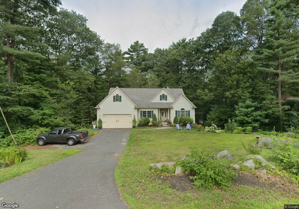
18 Maxwell Rd Monson, MA 01057
Estimated Value: $476,754 - $673,000
3
Beds
2
Baths
1,825
Sq Ft
$297/Sq Ft
Est. Value
About This Home
This home is located at 18 Maxwell Rd, Monson, MA 01057 and is currently estimated at $542,439, approximately $297 per square foot. 18 Maxwell Rd is a home located in Hampden County with nearby schools including Quarry Hill Community School, Granite Valley School, and Monson High School.
Ownership History
Date
Name
Owned For
Owner Type
Purchase Details
Closed on
May 14, 2007
Sold by
Lemon William F
Bought by
Trumbull Christine and Trumbull Mark
Current Estimated Value
Home Financials for this Owner
Home Financials are based on the most recent Mortgage that was taken out on this home.
Original Mortgage
$297,900
Outstanding Balance
$181,599
Interest Rate
6.21%
Mortgage Type
Purchase Money Mortgage
Estimated Equity
$360,840
Purchase Details
Closed on
Jul 27, 2006
Sold by
Condino Kimberly A and Condino Ronald M
Bought by
Lemon William F
Purchase Details
Closed on
Jun 29, 2004
Sold by
Bogoff Deborah and Bogoff Gary A
Bought by
Condino Kimberly A and Condino Ronald M
Home Financials for this Owner
Home Financials are based on the most recent Mortgage that was taken out on this home.
Original Mortgage
$36,000
Interest Rate
6.32%
Mortgage Type
Purchase Money Mortgage
Create a Home Valuation Report for This Property
The Home Valuation Report is an in-depth analysis detailing your home's value as well as a comparison with similar homes in the area
Home Values in the Area
Average Home Value in this Area
Purchase History
| Date | Buyer | Sale Price | Title Company |
|---|---|---|---|
| Trumbull Christine | $331,000 | -- | |
| Lemon William F | $54,000 | -- | |
| Condino Kimberly A | $45,000 | -- |
Source: Public Records
Mortgage History
| Date | Status | Borrower | Loan Amount |
|---|---|---|---|
| Open | Trumbull Christine | $297,900 | |
| Previous Owner | Condino Kimberly A | $36,000 |
Source: Public Records
Tax History Compared to Growth
Tax History
| Year | Tax Paid | Tax Assessment Tax Assessment Total Assessment is a certain percentage of the fair market value that is determined by local assessors to be the total taxable value of land and additions on the property. | Land | Improvement |
|---|---|---|---|---|
| 2025 | $6,449 | $433,700 | $73,300 | $360,400 |
| 2024 | $6,298 | $406,300 | $73,300 | $333,000 |
| 2023 | $5,970 | $376,400 | $73,300 | $303,100 |
| 2022 | $5,672 | $318,100 | $73,300 | $244,800 |
| 2021 | $5,344 | $294,900 | $73,300 | $221,600 |
| 2020 | $2,928 | $294,900 | $73,300 | $221,600 |
| 2019 | $5,249 | $280,500 | $73,300 | $207,200 |
| 2018 | $4,974 | $282,600 | $80,700 | $201,900 |
| 2017 | $4,978 | $272,000 | $77,400 | $194,600 |
| 2016 | $4,763 | $278,200 | $77,500 | $200,700 |
| 2015 | $4,469 | $268,100 | $77,500 | $190,600 |
| 2014 | $4,343 | $268,100 | $77,500 | $190,600 |
Source: Public Records
Map
Nearby Homes
- 60 Lakeshore Dr
- 371 Wilbraham St
- L16 Wilbraham St
- 187 Hovey Rd
- 183 Hovey Rd
- 6 Hawthorne Rd
- 0 Hovey Rd
- 182 Mountain Rd
- 474-480 Mountain Rd
- 2136 Baptist Hill Rd
- 1247 Calkins Rd
- 225 Maynard Rd
- 733 Monson Rd
- 15 Quaboag Valley Co-Op St Unit 15
- 474 Mountain Rd
- 38 King Dr
- 751 Ridge Rd
- 1682 N Main St
- 12 Highridge Rd
- 1029 Wilson St