S
Seller's Agent in 2025
Susan and Jen Rothstein Team
Hammond Residential Real Estate
(617) 731-4644
14 in this area
47 Total Sales
Estimated Value: $1,864,000 - $2,060,301
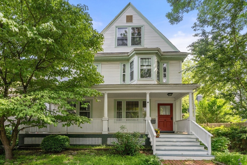
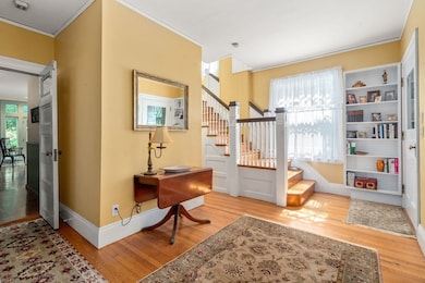
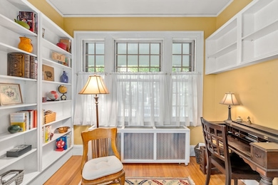
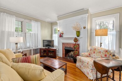
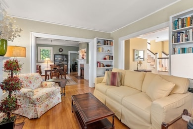
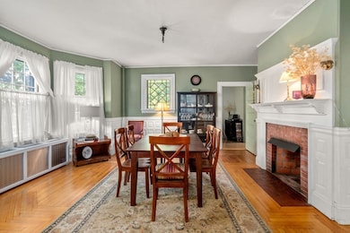
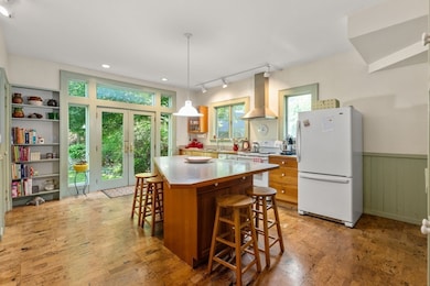
Set on a pretty tree-lined street, this eleven room residence presents a wonderful opportunity. Built in the late 1890s as a single family, it is now occupied as a Philadelphia-style two family and features charming front porch and living space with original detail. The first apartment offers a large entry with an alcove, living room with fireplace, dining room with bay window and fireplace, office, and kitchen with island and French doors to yard. A half bathroom/laundry completes the first floor. An original staircase leads to second level with two bedrooms and a full hall bathroom. A side entrance opens to the second apartment with two bedrooms, one with fireplace, and a hall full bathroom on the second floor. The third floor has a kitchen/dining/sitting room, two bedrooms, and bathroom with laundry. There is a private yard plus 3-car driveway. Terrific location near schools, cafes, markets, “T”, and #60 bus to Chestnut Hill and Medical Area and green spaces of Brookline.
Last Agent to Sell the Property
Hammond Residential Real Estate Listed on: 06/10/2025

| Date | Buyer | Sale Price | Title Company |
|---|---|---|---|
| Friedman Evelyn | $1,900,000 | -- | |
| Friedman Evelyn | $1,900,000 | -- | |
| Vrabel Susan J | $395,838 | -- | |
| Vrabel James A | -- | -- | |
| Vrabel Susan J | $395,838 | -- | |
| Vrabel Susan J | $395,838 | -- | |
| Vrabel James A | -- | -- | |
| Vrabel James A | $280,000 | -- | |
| Vrabel James A | $280,000 | -- |
| Date | Status | Borrower | Loan Amount |
|---|---|---|---|
| Open | Friedman Evelyn | $800,000 | |
| Closed | Friedman Evelyn | $800,000 | |
| Previous Owner | Vrabel James A | $130,000 |
| Date | Event | Price | List to Sale | Price per Sq Ft |
|---|---|---|---|---|
| 08/08/2025 08/08/25 | Sold | $1,900,000 | -5.0% | $488 / Sq Ft |
| 06/17/2025 06/17/25 | Pending | -- | -- | -- |
| 06/10/2025 06/10/25 | For Sale | $2,000,000 | -- | $513 / Sq Ft |
| Year | Tax Paid | Tax Assessment Tax Assessment Total Assessment is a certain percentage of the fair market value that is determined by local assessors to be the total taxable value of land and additions on the property. | Land | Improvement |
|---|---|---|---|---|
| 2025 | $20,963 | $2,123,900 | $1,229,700 | $894,200 |
| 2024 | $19,933 | $2,040,200 | $1,182,400 | $857,800 |
| 2023 | $19,147 | $1,920,500 | $1,017,700 | $902,800 |
| 2022 | $18,639 | $1,829,100 | $969,300 | $859,800 |
| 2021 | $17,236 | $1,758,800 | $932,000 | $826,800 |
| 2020 | $15,701 | $1,661,500 | $847,200 | $814,300 |
| 2019 | $14,827 | $1,582,400 | $806,900 | $775,500 |
| 2018 | $13,893 | $1,468,600 | $707,000 | $761,600 |
| 2017 | $13,688 | $1,385,400 | $667,000 | $718,400 |
| 2016 | $13,492 | $1,294,800 | $623,400 | $671,400 |
| 2015 | $13,001 | $1,217,300 | $582,600 | $634,700 |
| 2014 | $12,840 | $1,127,300 | $529,600 | $597,700 |
S
Seller's Agent in 2025
Susan and Jen Rothstein Team
Hammond Residential Real Estate
(617) 731-4644
14 in this area
47 Total Sales
S
Seller Co-Listing Agent in 2025
Susan Rothstein
Hammond Residential Real Estate
(617) 875-2088
3 in this area
6 Total Sales
J
Seller Co-Listing Agent in 2025
Jennifer Rothstein
Hammond Residential Real Estate
7 in this area
31 Total Sales
Buyer's Agent in 2025
Stephen Lussier
Arborview Realty Inc.
(617) 943-9500
1 in this area
67 Total Sales
Source: MLS Property Information Network (MLS PIN)
MLS Number: 73388474
APN: BROO-000320-000011
Disclaimer: Certain information contained herein is derived from information provided by parties other than Homes.com. All information provided is deemed reliable, but is not guaranteed to be accurate and should be independently verified.
![]() The property listing data and information, or the Images, set forth herein were provided to MLS Property Information Network, Inc. from third party sources, including sellers, lessors and public records, and were compiled by MLS Property Information Network, Inc. The property listing data and information, and the Images, are for the personal, non-commercial use of consumers having a good faith interest in purchasing or leasing listed properties of the type displayed to them and may not be used for any purpose other than to identify prospective properties which such consumers may have a good faith interest in purchasing or leasing. MLS Property Information Network, Inc. and its subscribers disclaim any and all representations and warranties as to the accuracy of the property listing data and information, or as to the accuracy of any of the Images, set forth herein.
The property listing data and information, or the Images, set forth herein were provided to MLS Property Information Network, Inc. from third party sources, including sellers, lessors and public records, and were compiled by MLS Property Information Network, Inc. The property listing data and information, and the Images, are for the personal, non-commercial use of consumers having a good faith interest in purchasing or leasing listed properties of the type displayed to them and may not be used for any purpose other than to identify prospective properties which such consumers may have a good faith interest in purchasing or leasing. MLS Property Information Network, Inc. and its subscribers disclaim any and all representations and warranties as to the accuracy of the property listing data and information, or as to the accuracy of any of the Images, set forth herein.
Ask me questions while you tour the home.