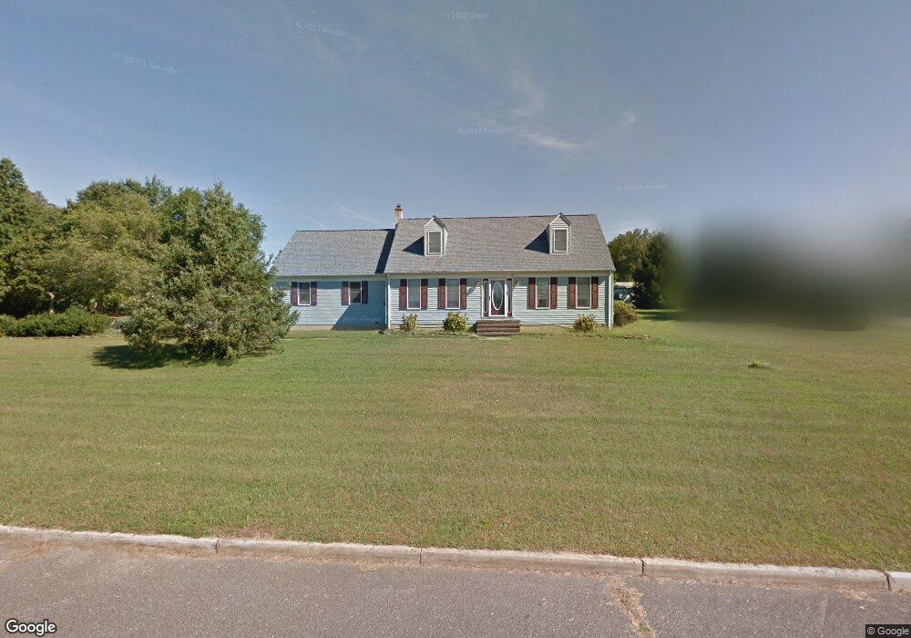
18 Myron Blvd Wrightstown, NJ 08562
Estimated Value: $455,845 - $543,000
About This Home
This home is located at 18 Myron Blvd, Wrightstown, NJ 08562 and is currently estimated at $495,961, approximately $295 per square foot. 18 Myron Blvd is a home located in Burlington County with nearby schools including C.B. Lamb Elementary School, North Hanover Township Upper Elementary School, and Northern Burlington County Regional Middle School.
Ownership History
Purchase Details
Home Financials for this Owner
Home Financials are based on the most recent Mortgage that was taken out on this home.Purchase Details
Purchase Details
Home Values in the Area
Average Home Value in this Area
Purchase History
We collect this data history from publicly available records. To have your information removed, we recommend requesting removal directly through your county’s website.
| Date | Buyer | Sale Price | Title Company |
|---|---|---|---|
| Estwan Christopher | $274,900 | Starr Title Agency | |
| Trenka Dale A | $188,000 | -- | |
| Applegate Deborah A | -- | Supreme Title Agency Inc |
Mortgage History
We collect this data history from publicly available records. To have your information removed, we recommend requesting removal directly through your county’s website.
| Date | Status | Borrower | Loan Amount |
|---|---|---|---|
| Open | Estwan Christopher | $247,400 | |
| Previous Owner | Trenka Dale A | $199,450 | |
| Previous Owner | Trenka Dale A | $199,450 |
Tax History
| Year | Tax Paid | Tax Assessment Tax Assessment Total Assessment is a certain percentage of the fair market value that is determined by local assessors to be the total taxable value of land and additions on the property. | Land | Improvement |
|---|---|---|---|---|
| 2025 | $6,414 | $268,800 | $67,800 | $201,000 |
| 2024 | $5,940 | $268,800 | $67,800 | $201,000 |
| 2023 | $5,940 | $268,800 | $67,800 | $201,000 |
| 2022 | $5,965 | $268,800 | $67,800 | $201,000 |
| 2021 | $6,045 | $268,800 | $67,800 | $201,000 |
| 2020 | $6,029 | $268,800 | $67,800 | $201,000 |
| 2019 | $5,978 | $268,800 | $67,800 | $201,000 |
| 2018 | $5,709 | $268,800 | $67,800 | $201,000 |
| 2017 | $5,588 | $268,800 | $67,800 | $201,000 |
| 2016 | $5,572 | $268,800 | $67,800 | $201,000 |
| 2015 | $5,572 | $268,800 | $67,800 | $201,000 |
| 2014 | $5,247 | $268,800 | $67,800 | $201,000 |
Map
- 81 Jacobstown Cookstown Rd
- 194 Jacobstown New Egypt Rd Unit 4
- 194 Jacobstown New Egypt Rd Unit 2
- 194 Jacobstown New Egypt Rd
- 269 Jacobstown New Egypt Rd
- 53 Meany Rd
- 301 Meany Rd
- 134 Schoolhouse Rd
- 621 Hanover Dr
- 377 Jacobstown Cookstown Rd
- 181 Cookstown New Egypt Rd Unit B37
- 44 Churchill Blvd
- 52 Belmont Rd
- XX Cookstown New Egypt Rd
- 6 Mary St
- 5 Aqueduct Blvd
- 10 Mary St
- 114 Cookstown New Egypt Rd
- 38 Keeneland Rd
- 40 Emerald Rd
Ask me questions while you tour the home.