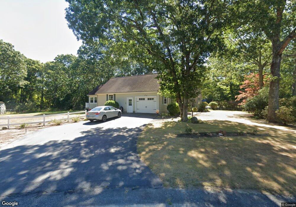
18 Pierce Way E East Freetown, MA 02717
Estimated Value: $654,785 - $752,000
3
Beds
3
Baths
1,840
Sq Ft
$376/Sq Ft
Est. Value
About This Home
This home is located at 18 Pierce Way E, East Freetown, MA 02717 and is currently estimated at $691,196, approximately $375 per square foot. 18 Pierce Way E is a home located in Bristol County with nearby schools including Freetown Elementary School, George R Austin Intermediate School, and Freetown-Lakeville Middle School.
Ownership History
Date
Name
Owned For
Owner Type
Purchase Details
Closed on
Nov 14, 1984
Bought by
Medeiros Michael J and Medeiros Darlene L
Current Estimated Value
Create a Home Valuation Report for This Property
The Home Valuation Report is an in-depth analysis detailing your home's value as well as a comparison with similar homes in the area
Home Values in the Area
Average Home Value in this Area
Purchase History
| Date | Buyer | Sale Price | Title Company |
|---|---|---|---|
| Medeiros Michael J | $17,500 | -- |
Source: Public Records
Mortgage History
| Date | Status | Borrower | Loan Amount |
|---|---|---|---|
| Open | Medeiros Michael J | $150,000 | |
| Closed | Medeiros Michael J | $30,000 |
Source: Public Records
Tax History Compared to Growth
Tax History
| Year | Tax Paid | Tax Assessment Tax Assessment Total Assessment is a certain percentage of the fair market value that is determined by local assessors to be the total taxable value of land and additions on the property. | Land | Improvement |
|---|---|---|---|---|
| 2025 | $5,881 | $593,400 | $188,500 | $404,900 |
| 2024 | $5,842 | $560,100 | $177,800 | $382,300 |
| 2023 | $5,691 | $531,400 | $160,200 | $371,200 |
| 2022 | $5,422 | $449,600 | $135,700 | $313,900 |
| 2021 | $5,244 | $412,900 | $123,400 | $289,500 |
| 2020 | $5,191 | $398,700 | $118,700 | $280,000 |
| 2019 | $4,965 | $377,600 | $118,400 | $259,200 |
| 2018 | $4,702 | $353,300 | $118,400 | $234,900 |
| 2017 | $4,561 | $342,400 | $118,400 | $224,000 |
| 2016 | $4,352 | $332,500 | $115,000 | $217,500 |
| 2015 | $4,203 | $325,800 | $109,800 | $216,000 |
| 2014 | $3,735 | $296,200 | $112,600 | $183,600 |
Source: Public Records
Map
Nearby Homes
- 144 Chace Rd
- 195 Slab Bridge Rd
- 0 Costa Dr
- 150 Quanapoag Rd
- Lot 2/3 Quanapoag Rd
- 599 Quanapoag Rd
- 1475 Braley Rd Unit 17
- 24 Bells Brook Rd
- 264 Collins Corner Rd
- 13 Luscomb Ln
- 4597 Acushnet Ave
- 16 Swallow St
- 111 High St
- 1069 Cherokee St
- 7 Great Cedar Crossing
- 353 Upland St
- 20 Slab Bridge Rd
- 9 Paul Ave
- 319 Northwest St
- 64 Blaze Rd