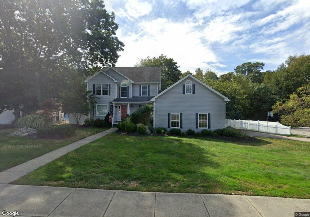
18 Shea Dr Pawcatuck, CT 06379
Estimated Value: $597,000 - $760,000
4
Beds
3
Baths
2,388
Sq Ft
$293/Sq Ft
Est. Value
About This Home
This home is located at 18 Shea Dr, Pawcatuck, CT 06379 and is currently estimated at $698,902, approximately $292 per square foot. 18 Shea Dr is a home located in New London County with nearby schools including Stonington Middle School, Stonington High School, and Pine Point School.
Ownership History
Date
Name
Owned For
Owner Type
Purchase Details
Closed on
Nov 2, 2005
Sold by
Skirig Dev Inc
Bought by
Walsh Andrew J and Walsh Leslie E
Current Estimated Value
Home Financials for this Owner
Home Financials are based on the most recent Mortgage that was taken out on this home.
Original Mortgage
$217,500
Outstanding Balance
$117,784
Interest Rate
5.85%
Estimated Equity
$581,118
Create a Home Valuation Report for This Property
The Home Valuation Report is an in-depth analysis detailing your home's value as well as a comparison with similar homes in the area
Home Values in the Area
Average Home Value in this Area
Purchase History
| Date | Buyer | Sale Price | Title Company |
|---|---|---|---|
| Walsh Andrew J | $432,400 | -- | |
| Walsh Andrew J | $432,400 | -- |
Source: Public Records
Mortgage History
| Date | Status | Borrower | Loan Amount |
|---|---|---|---|
| Open | Walsh Andrew J | $217,500 | |
| Closed | Walsh Andrew J | $217,500 |
Source: Public Records
Tax History
| Year | Tax Paid | Tax Assessment Tax Assessment Total Assessment is a certain percentage of the fair market value that is determined by local assessors to be the total taxable value of land and additions on the property. | Land | Improvement |
|---|---|---|---|---|
| 2025 | $8,041 | $404,500 | $86,700 | $317,800 |
| 2024 | $7,706 | $404,500 | $86,700 | $317,800 |
| 2023 | $7,707 | $404,500 | $86,700 | $317,800 |
| 2022 | $6,838 | $267,000 | $65,800 | $201,200 |
| 2021 | $5,645 | $267,000 | $65,800 | $201,200 |
| 2020 | $5,649 | $267,000 | $65,800 | $201,200 |
| 2019 | $5,417 | $267,000 | $65,800 | $201,200 |
| 2018 | $6,477 | $267,000 | $65,800 | $201,200 |
| 2017 | $4,970 | $255,300 | $68,800 | $186,500 |
| 2016 | $6,114 | $255,300 | $68,800 | $186,500 |
| 2015 | $5,739 | $255,300 | $68,800 | $186,500 |
| 2014 | $5,614 | $255,300 | $68,800 | $186,500 |
Source: Public Records
Map
Nearby Homes
- 2 Pawcatuck Ave
- 60 Margin St Unit 102
- 93 S Broad St
- 0 River Unit 24129909
- 13 Palmer St
- 65 Mechanic St
- 15 Moss St
- 51 Pequot Trail
- 141 W Broad St
- 23 Abbey Ln Unit 12
- 24 Abbey Ln Unit 13
- 39 Summertime Cir
- 25 Summertime Cir
- 25 School St Unit 2
- 38 Summertime Cir
- 22 Summertime Cir
- 23 Summertime Cir
- 45 Summertime Cir
- 16 Spring St
- 24 George St
Your Personal Tour Guide
Ask me questions while you tour the home.