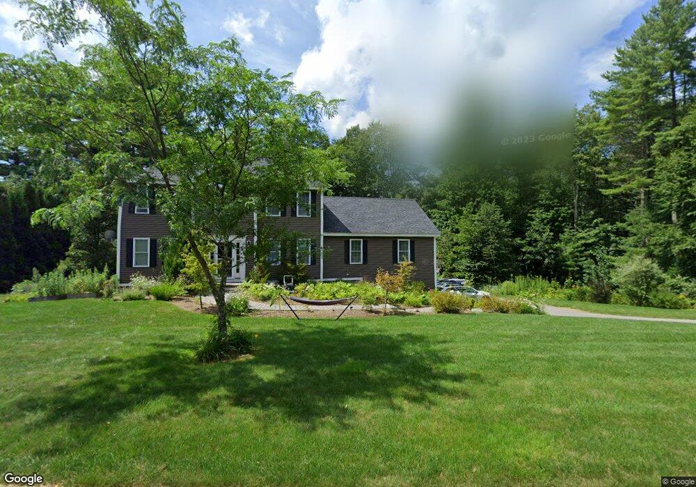
18 Wildbrook Dr Rutland, MA 01543
Estimated Value: $602,000 - $694,000
3
Beds
3
Baths
2,248
Sq Ft
$294/Sq Ft
Est. Value
About This Home
This home is located at 18 Wildbrook Dr, Rutland, MA 01543 and is currently estimated at $661,476, approximately $294 per square foot. 18 Wildbrook Dr is a home with nearby schools including Wachusett Regional High School.
Ownership History
Date
Name
Owned For
Owner Type
Purchase Details
Closed on
May 22, 2020
Sold by
Sterner Jack H
Bought by
Sterner Jack H and Sterner Deeana
Current Estimated Value
Purchase Details
Closed on
Jan 30, 2014
Sold by
Pleasantdale Estates L
Bought by
Sterner Jack H
Home Financials for this Owner
Home Financials are based on the most recent Mortgage that was taken out on this home.
Original Mortgage
$342,801
Interest Rate
4.47%
Mortgage Type
VA
Create a Home Valuation Report for This Property
The Home Valuation Report is an in-depth analysis detailing your home's value as well as a comparison with similar homes in the area
Home Values in the Area
Average Home Value in this Area
Purchase History
| Date | Buyer | Sale Price | Title Company |
|---|---|---|---|
| Sterner Jack H | -- | None Available | |
| Sterner Jack H | $331,850 | -- |
Source: Public Records
Mortgage History
| Date | Status | Borrower | Loan Amount |
|---|---|---|---|
| Previous Owner | Sterner Jack H | $342,801 | |
| Previous Owner | Sterner Jack H | $255,000 |
Source: Public Records
Tax History Compared to Growth
Tax History
| Year | Tax Paid | Tax Assessment Tax Assessment Total Assessment is a certain percentage of the fair market value that is determined by local assessors to be the total taxable value of land and additions on the property. | Land | Improvement |
|---|---|---|---|---|
| 2025 | $8,582 | $602,700 | $123,800 | $478,900 |
| 2024 | $8,134 | $548,500 | $111,800 | $436,700 |
| 2023 | $7,418 | $540,700 | $105,600 | $435,100 |
| 2022 | $6,984 | $442,300 | $90,300 | $352,000 |
| 2021 | $6,743 | $403,800 | $90,300 | $313,500 |
| 2020 | $6,341 | $360,100 | $85,400 | $274,700 |
| 2019 | $6,308 | $352,600 | $78,600 | $274,000 |
| 2018 | $6,061 | $334,300 | $78,600 | $255,700 |
| 2017 | $6,178 | $337,200 | $78,600 | $258,600 |
| 2016 | $5,678 | $326,900 | $75,000 | $251,900 |
| 2015 | $5,553 | $314,600 | $75,000 | $239,600 |
| 2014 | $5,383 | $314,600 | $75,000 | $239,600 |
Source: Public Records
Map
Nearby Homes
- 211 Barre Paxton Rd Unit 4
- 0 Barclay Rd
- 0 Browning Pond Rd
- Lot 11 Pleasantdale Rd
- 43 Irish Ln
- 39 Irish Ln
- 37 Irish Ln
- 238 Barre Paxton Rd Unit 238
- LOT 8 Pierre Cir
- 47 Lakeshore Dr
- 196 N Spencer Rd
- 236 Turkey Hill Rd
- 5 Brigham Rd
- 21 Spencer Rd
- 49 Oak Ln
- 18 Shore Dr
- 17 Shore Dr
- Lot 1 Welch Ave
- 7 Victoria Ave
- 14 Welch Ave Unit B
- 14 Wildbrook Dr
- 20 Wildbrook Dr
- 10 Wildbrook Dr
- 24 Wildbrook Dr
- 15 Wildbrook Dr
- 28 Wildbrook Dr
- 21 Wildbrook Dr
- 21 Wildbrook Dr Unit 21
- 25 Wildbrook Dr
- 8 Wildbrook Dr
- 30 Wildbrook Dr
- 9 Wildbrook Dr
- 7 Wildbrook Dr
- 31 Wildbrook Dr
- 5 Wildbrook Dr
- 34 Wildbrook Dr
- 352 Pleasantdale Rd
- 38 Wildbrook Dr
- 346 Pleasantdale Rd
- 350 Pleasantdale Rd