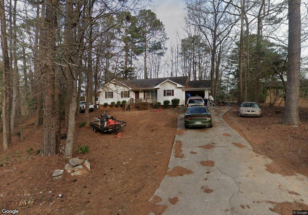
180 Bunker Dr Athens, GA 30607
Estimated Value: $305,412 - $343,000
4
Beds
2
Baths
1,676
Sq Ft
$193/Sq Ft
Est. Value
About This Home
This home is located at 180 Bunker Dr, Athens, GA 30607 and is currently estimated at $322,853, approximately $192 per square foot. 180 Bunker Dr is a home located in Clarke County with nearby schools including Burney-Harris-Lyons Middle School, Clarke Central High School, and Prince Ave Christian School.
Ownership History
Date
Name
Owned For
Owner Type
Purchase Details
Closed on
Nov 28, 2005
Sold by
Schilling Michael Ray
Bought by
Dixon Sandra J
Current Estimated Value
Home Financials for this Owner
Home Financials are based on the most recent Mortgage that was taken out on this home.
Original Mortgage
$111,920
Outstanding Balance
$87,176
Interest Rate
7.85%
Mortgage Type
New Conventional
Estimated Equity
$235,677
Purchase Details
Closed on
Nov 25, 2003
Sold by
Reddy K Sujatha
Bought by
Schilling Michael Ray
Purchase Details
Closed on
Jul 31, 1997
Sold by
Cartey Maurice
Bought by
Reddy K Sujatha
Purchase Details
Closed on
Aug 19, 1996
Sold by
Russo Barbara
Bought by
Cartey Maurice
Create a Home Valuation Report for This Property
The Home Valuation Report is an in-depth analysis detailing your home's value as well as a comparison with similar homes in the area
Home Values in the Area
Average Home Value in this Area
Purchase History
| Date | Buyer | Sale Price | Title Company |
|---|---|---|---|
| Dixon Sandra J | $139,900 | -- | |
| Schilling Michael Ray | $130,900 | -- | |
| Reddy K Sujatha | $99,000 | -- | |
| Cartey Maurice | $9,600 | -- |
Source: Public Records
Mortgage History
| Date | Status | Borrower | Loan Amount |
|---|---|---|---|
| Open | Dixon Sandra J | $111,920 | |
| Closed | Dixon Sandra J | $27,980 |
Source: Public Records
Tax History Compared to Growth
Tax History
| Year | Tax Paid | Tax Assessment Tax Assessment Total Assessment is a certain percentage of the fair market value that is determined by local assessors to be the total taxable value of land and additions on the property. | Land | Improvement |
|---|---|---|---|---|
| 2025 | $2,589 | $100,212 | $16,000 | $84,212 |
| 2024 | $2,589 | $97,904 | $16,000 | $81,904 |
| 2023 | $1,853 | $94,292 | $16,000 | $78,292 |
| 2022 | $2,245 | $80,374 | $16,000 | $64,374 |
| 2021 | $1,722 | $61,108 | $12,000 | $49,108 |
| 2020 | $1,589 | $57,166 | $12,000 | $45,166 |
| 2019 | $1,463 | $53,104 | $12,000 | $41,104 |
| 2018 | $1,305 | $48,427 | $12,000 | $36,427 |
| 2017 | $1,278 | $47,633 | $12,000 | $35,633 |
| 2016 | $1,112 | $42,742 | $12,000 | $30,742 |
| 2015 | $1,139 | $43,502 | $12,000 | $31,502 |
| 2014 | $1,145 | $43,618 | $12,000 | $31,618 |
Source: Public Records
Map
Nearby Homes