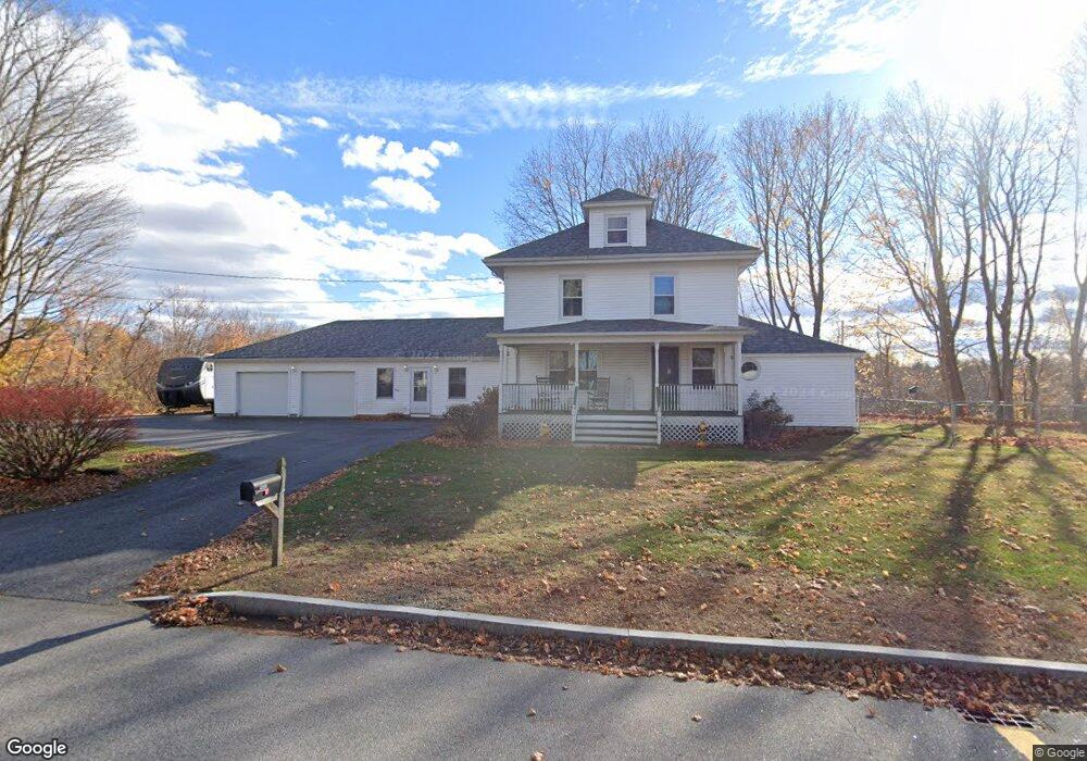
180 Conant St Westbrook, ME 04092
Estimated Value: $535,000 - $625,000
4
Beds
3
Baths
2,740
Sq Ft
$207/Sq Ft
Est. Value
About This Home
This home is located at 180 Conant St, Westbrook, ME 04092 and is currently estimated at $566,307, approximately $206 per square foot. 180 Conant St is a home located in Cumberland County with nearby schools including Westbrook High School, The Little Dolphin School Foundation, and Breakwater School.
Ownership History
Date
Name
Owned For
Owner Type
Purchase Details
Closed on
Mar 6, 2008
Sold by
Flannery Flannery G and Flannery Karen L
Bought by
Flannery G Daniel
Current Estimated Value
Create a Home Valuation Report for This Property
The Home Valuation Report is an in-depth analysis detailing your home's value as well as a comparison with similar homes in the area
Home Values in the Area
Average Home Value in this Area
Purchase History
We collect this data history from publicly available records. To have your information removed, we recommend requesting removal directly through your county’s website.
| Date | Buyer | Sale Price | Title Company |
|---|---|---|---|
| Flannery G Daniel | -- | -- |
Source: Public Records
Mortgage History
We collect this data history from publicly available records. To have your information removed, we recommend requesting removal directly through your county’s website.
| Date | Status | Borrower | Loan Amount |
|---|---|---|---|
| Previous Owner | Flannery G Daniel | $59,000 |
Source: Public Records
Tax History
| Year | Tax Paid | Tax Assessment Tax Assessment Total Assessment is a certain percentage of the fair market value that is determined by local assessors to be the total taxable value of land and additions on the property. | Land | Improvement |
|---|---|---|---|---|
| 2023 | $6,609 | $396,200 | $86,100 | $310,100 |
| 2022 | $6,000 | $331,500 | $71,700 | $259,800 |
| 2021 | $5,911 | $331,500 | $71,700 | $259,800 |
| 2020 | $1,913 | $331,500 | $71,700 | $259,800 |
| 2019 | $3,040 | $331,500 | $71,700 | $259,800 |
| 2018 | $15,200 | $306,200 | $62,300 | $243,900 |
| 2017 | $20,901 | $306,200 | $62,300 | $243,900 |
| 2016 | $5,634 | $306,200 | $62,300 | $243,900 |
| 2015 | $5,499 | $306,200 | $62,300 | $243,900 |
| 2014 | $5,267 | $306,200 | $62,300 | $243,900 |
| 2013 | $5,267 | $306,200 | $62,300 | $243,900 |
Source: Public Records
Map
Nearby Homes
- 20 Juniper Ln Unit 16
- 30 Lincoln St Unit 220
- 30 Lincoln St Unit 12
- 30 Lincoln St Unit 215
- 48 Longfellow St
- 44 Hogan Cir Unit 5
- 42 Hogan Cir Unit 6
- 10 Hogan Cir Unit 35
- 43 Kennard St
- 36 Arlington Ave
- 17 Mechanic St
- 74 Arlington Ave
- 132 North St
- 77 Mechanic St
- 243 Bridge St
- 18 Cole St
- 206 Lyman St
- 262 Bridge St
- 18 Green St
- 71 North St
- 173 Conant St
- 189 Conant St
- 156 Conant St
- 156 Lot A Conant St
- 161 Conant St
- 00 Conant St
- 148 Conant St
- 213 Conant St
- 138 Conant St Unit 4
- 153 Conant St
- 219 Conant St
- 220 Conant St
- 139 Conant St
- 139 Conant St Unit 1
- 227 Conant St
- 125 Conant St
- 10 Beatrice Ln
- 110 Conant St
- 236 Conant St
- 243 Conant St Unit 12
Your Personal Tour Guide
Ask me questions while you tour the home.