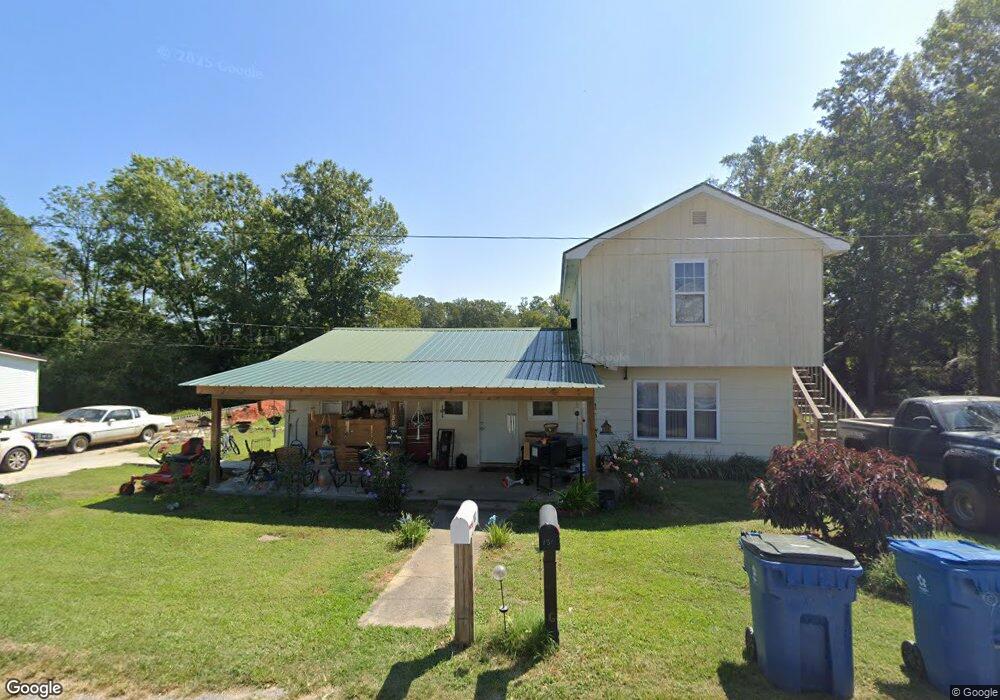
180 Cove Ln Union Grove, AL 35175
Estimated Value: $115,000 - $220,000
--
Bed
--
Bath
1,996
Sq Ft
$87/Sq Ft
Est. Value
About This Home
This home is located at 180 Cove Ln, Union Grove, AL 35175 and is currently estimated at $173,615, approximately $86 per square foot. 180 Cove Ln is a home located in Marshall County with nearby schools including Brindlee Mountain Primary School, Brindlee Mountain Elementary School, and Brindlee Mt Middle School.
Ownership History
Date
Name
Owned For
Owner Type
Purchase Details
Closed on
May 25, 2023
Sold by
Walker Brenda D
Bought by
Walker Brenda D and Walker Kodie
Current Estimated Value
Home Financials for this Owner
Home Financials are based on the most recent Mortgage that was taken out on this home.
Original Mortgage
$101,750
Outstanding Balance
$97,208
Interest Rate
6.39%
Mortgage Type
FHA
Estimated Equity
$76,407
Create a Home Valuation Report for This Property
The Home Valuation Report is an in-depth analysis detailing your home's value as well as a comparison with similar homes in the area
Home Values in the Area
Average Home Value in this Area
Purchase History
| Date | Buyer | Sale Price | Title Company |
|---|---|---|---|
| Walker Brenda D | -- | None Listed On Document | |
| Walker Brenda D | -- | None Listed On Document |
Source: Public Records
Mortgage History
| Date | Status | Borrower | Loan Amount |
|---|---|---|---|
| Open | Walker Brenda D | $101,750 | |
| Closed | Walker Brenda D | $101,750 |
Source: Public Records
Tax History Compared to Growth
Tax History
| Year | Tax Paid | Tax Assessment Tax Assessment Total Assessment is a certain percentage of the fair market value that is determined by local assessors to be the total taxable value of land and additions on the property. | Land | Improvement |
|---|---|---|---|---|
| 2024 | $874 | $11,660 | $0 | $0 |
| 2023 | $874 | $22,080 | $1,000 | $21,080 |
| 2022 | $0 | $10,700 | $0 | $0 |
| 2021 | $0 | $9,820 | $0 | $0 |
| 2020 | $327 | $8,720 | $0 | $0 |
| 2017 | $334 | $15,820 | $0 | $0 |
| 2015 | -- | $10,920 | $0 | $0 |
| 2014 | -- | $10,920 | $0 | $0 |
Source: Public Records
Map
Nearby Homes
- 476 Cedar Ridge Dr
- 187 Deer Trail
- 201 Deer Trail
- 572 McDermont Rd
- 6 Acres New Friendship Rd
- 0 Thurman Rd
- 3145 Union Grove Rd
- 803 Mobb Hill Rd
- 173 Brock Chapel Rd
- 269 Sue Nora Dr
- 8324 Union Grove Rd
- 1808 Union Grove Rd
- 58 Sweet Home Rd
- 3582 Friendship Rd
- 865 Quarry Rd
- 4357 Merrill Mountain Rd
- 83 Lions Dr
- 417 Dodd Rd
- 2495 Eddy Scant City Rd
- 123 Chambers Rd
- 190 Cove Ln
- 204 Cove Ln
- 0 Cedar Ridge Dr Unit 1028511
- 471 Cedar Ridge Dr
- 437 Cedar Ridge Dr
- 529 Cedar Ridge Dr
- 551 Cedar Ridge Dr
- 387 Cedar Ridge Dr
- Lot 5 Cedar Ridge Dr
- 150 Ridge Dr
- 398 Cedar Ridge Dr
- 337 Cedar Ridge Dr
- 510 Cedar Ridge Dr
- 307 Cedar Ridge Dr
- 344 Cedar Ridge Dr
- 105 Ridge Dr
- 359 Cedar Ridge Dr
- 364 Cedar Ridge Dr
- 43 Cotton Seed Dr
- 68 Cotton Seed Dr