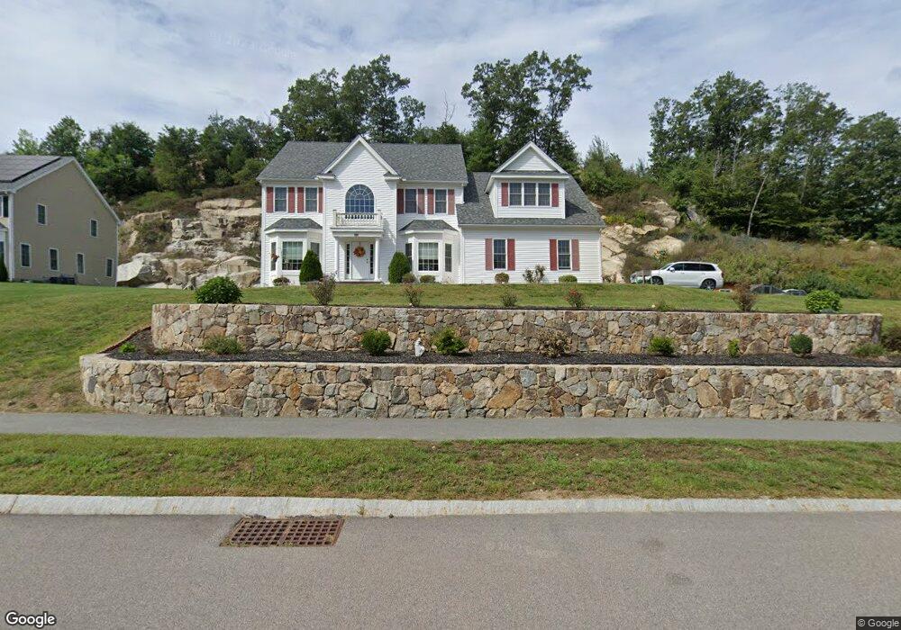
180 Mohawk Path Holliston, MA 01746
Estimated Value: $1,120,610 - $1,335,000
4
Beds
4
Baths
2,970
Sq Ft
$421/Sq Ft
Est. Value
About This Home
This home is located at 180 Mohawk Path, Holliston, MA 01746 and is currently estimated at $1,249,903, approximately $420 per square foot. 180 Mohawk Path is a home with nearby schools including Placentino Elementary School, Miller Elementary School, and Robert H. Adams Middle School.
Ownership History
Date
Name
Owned For
Owner Type
Purchase Details
Closed on
Jan 25, 2016
Sold by
Highlands At Holliston
Bought by
Shen Chen and Shen Zufang
Current Estimated Value
Home Financials for this Owner
Home Financials are based on the most recent Mortgage that was taken out on this home.
Original Mortgage
$497,000
Outstanding Balance
$389,149
Interest Rate
3.98%
Mortgage Type
New Conventional
Estimated Equity
$860,754
Create a Home Valuation Report for This Property
The Home Valuation Report is an in-depth analysis detailing your home's value as well as a comparison with similar homes in the area
Home Values in the Area
Average Home Value in this Area
Purchase History
We collect this data history from publicly available records. To have your information removed, we recommend requesting removal directly through your county’s website.
| Date | Buyer | Sale Price | Title Company |
|---|---|---|---|
| Shen Chen | $720,000 | -- | |
| Highlands At Holliston | -- | -- |
Source: Public Records
Mortgage History
We collect this data history from publicly available records. To have your information removed, we recommend requesting removal directly through your county’s website.
| Date | Status | Borrower | Loan Amount |
|---|---|---|---|
| Open | Shen Chen | $497,000 |
Source: Public Records
Tax History
| Year | Tax Paid | Tax Assessment Tax Assessment Total Assessment is a certain percentage of the fair market value that is determined by local assessors to be the total taxable value of land and additions on the property. | Land | Improvement |
|---|---|---|---|---|
| 2025 | $14,883 | $1,015,900 | $275,000 | $740,900 |
| 2024 | $14,802 | $982,900 | $275,000 | $707,900 |
| 2023 | $14,176 | $920,500 | $275,000 | $645,500 |
| 2022 | $13,344 | $767,800 | $275,000 | $492,800 |
| 2021 | $14,410 | $807,300 | $260,000 | $547,300 |
| 2020 | $13,736 | $728,700 | $255,200 | $473,500 |
| 2019 | $13,580 | $721,200 | $247,700 | $473,500 |
| 2018 | $13,465 | $721,200 | $247,700 | $473,500 |
| 2017 | $12,066 | $651,500 | $260,400 | $391,100 |
| 2016 | $1,858 | $98,900 | $98,900 | $0 |
| 2015 | $3,804 | $196,300 | $196,300 | $0 |
Source: Public Records
Map
Nearby Homes
- 85 Old Cart Path
- 9 Adams Ln Unit 9
- 7 Adams Ln Unit 7
- 162 Western Ave
- 32 Sherborne Cir
- 147 Turner Rd Unit 73
- 152 Turner Rd Unit 52
- 152 Turner Rd Unit 3
- 157 Leland Farm Rd
- 135 Locust St
- 146 Mountain Gate Rd
- 3 Knollcrest Farm Ln
- 9 Running Brook Cir
- 37 Temi Rd
- 3 Shady Hollow Path
- 29 Southfield Ln Unit 29
- 26 Southfield Ln Unit 26
- 207 Eliot St
- 215 Washington St
- 73 Half Crown Cir
- 176 Mohawk Path
- 187 Mohawk Path
- 179 Mohawk Path
- 32 Hiawatha Trail
- 175 Mohawk Path
- 183 Mohawk Path Unit lot 87
- 183 Mohawk Path
- Lot 56 Hiawatha Trail
- 172 Mohawk Path
- 172 Mohawk Path Unit 74
- 29 Hiawatha Trail
- 88 Mohawk Path Unit 88
- 169 Mohawk Path
- 186 Mohawk Path Unit Lot 77
- 186 Mohawk Path Unit 186
- 89 Mohawk Path Unit 89
- 28 Hiawatha Trail
- 111 Hiawatha Trail Unit lot 111
- 113 Hiawatha Trail Unit lot 113
- 108 Hiawatha Trail Unit lot 108
Your Personal Tour Guide
Ask me questions while you tour the home.