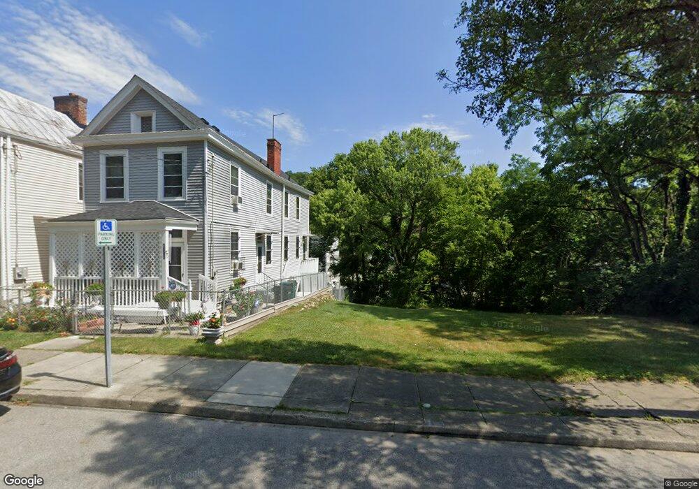
1800 Baltimore Ave Cincinnati, OH 45225
North Fairmount NeighborhoodEstimated Value: $100,000
2
Beds
1
Bath
1,304
Sq Ft
$77/Sq Ft
Est. Value
About This Home
This home is located at 1800 Baltimore Ave, Cincinnati, OH 45225 and is currently priced at $100,000, approximately $76 per square foot. 1800 Baltimore Ave is a home located in Hamilton County with nearby schools including Ethel M. Taylor Academy, Robert A. Taft Information Technology High School, and Western Hills High School.
Ownership History
Date
Name
Owned For
Owner Type
Purchase Details
Closed on
Mar 4, 2019
Sold by
Brice Angelo C
Bought by
Hamilton County Land Reutilization Corp
Current Estimated Value
Purchase Details
Closed on
Feb 8, 2012
Sold by
Hitchock Pamela E
Bought by
Brice Angelo C
Purchase Details
Closed on
May 30, 1996
Sold by
Hitchcock Pamela E and Gray Pamela E
Bought by
Hitchcock Pamela E and Gray Pamela E
Home Financials for this Owner
Home Financials are based on the most recent Mortgage that was taken out on this home.
Original Mortgage
$39,500
Interest Rate
7.97%
Mortgage Type
Purchase Money Mortgage
Purchase Details
Closed on
Oct 26, 1993
Sold by
Hitchcock Pamela and Gray Pamela E
Bought by
People Working Cooperatively Inc
Create a Home Valuation Report for This Property
The Home Valuation Report is an in-depth analysis detailing your home's value as well as a comparison with similar homes in the area
Home Values in the Area
Average Home Value in this Area
Purchase History
| Date | Buyer | Sale Price | Title Company |
|---|---|---|---|
| Hamilton County Land Reutilization Corp | -- | None Available | |
| Brice Angelo C | $5,395 | None Available | |
| Hitchcock Pamela E | -- | -- | |
| People Working Cooperatively Inc | -- | -- |
Source: Public Records
Mortgage History
| Date | Status | Borrower | Loan Amount |
|---|---|---|---|
| Previous Owner | Hitchcock Pamela E | $39,500 |
Source: Public Records
Tax History Compared to Growth
Tax History
| Year | Tax Paid | Tax Assessment Tax Assessment Total Assessment is a certain percentage of the fair market value that is determined by local assessors to be the total taxable value of land and additions on the property. | Land | Improvement |
|---|---|---|---|---|
| 2024 | -- | $613 | $613 | -- |
| 2023 | $428 | $613 | $613 | $0 |
| 2022 | $418 | $1,096 | $1,096 | $0 |
| 2021 | $8 | $1,096 | $1,096 | $0 |
| 2020 | $0 | $1,096 | $1,096 | $0 |
| 2019 | $367 | $6,997 | $1,096 | $5,901 |
| 2018 | $1,093 | $6,997 | $1,096 | $5,901 |
| 2017 | $495 | $6,997 | $1,096 | $5,901 |
| 2016 | $236 | $3,255 | $1,365 | $1,890 |
| 2015 | $214 | $3,255 | $1,365 | $1,890 |
| 2014 | $431 | $3,255 | $1,365 | $1,890 |
| 2013 | $216 | $3,224 | $1,351 | $1,873 |
Source: Public Records
Map
Nearby Homes
- 1797 Denham St
- 1808 Carll St
- 1770 Carll St
- 1756 Carll St
- 1854 Carll St
- 1859 Baltimore Ave
- 2568 Trevor Place
- 1721 Sutter Ave
- 1704 Pulte St
- 1674 Baltimore Ave
- 1646 Pulte St
- 1642 Sutter Ave
- 2521 Seegar Ave
- 2911 Moosewood Ct
- 1623 Sutter Ave
- 2652 Linden St
- 2650 Linden St
- 2654 Linden St
- 2658 Linden St
- 2656 Linden St
- 1802 Baltimore Ave
- 1798 Baltimore Ave
- 1804 Baltimore Ave
- 1799 Carll St
- 1801 Carll St
- 1790 Baltimore Ave
- 1808 Baltimore Ave
- 1805 Carll St
- 1807 Carll St
- 1799 Baltimore Ave
- 1812 Baltimore Ave
- 1797 Baltimore Ave
- 1795 Baltimore Ave
- 1793 Baltimore Ave
- 1809 Carll St
- 1791 Baltimore Ave
- 1805 Baltimore Ave
- 1803 Baltimore Ave
- 1782 Baltimore Ave
- 1813 Carll St