Estimated Value: $928,000 - $1,075,000
4
Beds
3
Baths
2,772
Sq Ft
$365/Sq Ft
Est. Value
About This Home
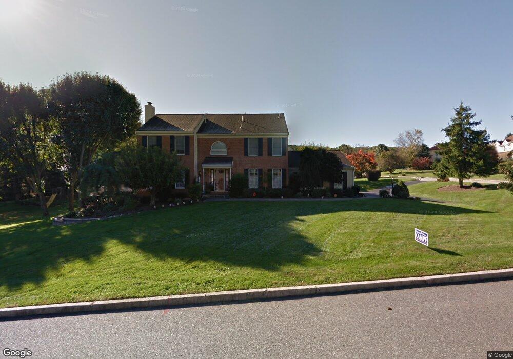
This home is located at 1800 Black Rock Ln, Paoli, PA 19301 and is currently estimated at $1,010,891, approximately $364 per square foot. 1800 Black Rock Ln is a home located in Chester County with nearby schools including Hillside Elementary School, Valley Forge Middle School, and Conestoga Senior High School.
Ownership History
Date
Name
Owned For
Owner Type
Purchase Details
Closed on
Feb 28, 2000
Sold by
Jacoppi John J and Jacoppi Necole O
Bought by
Schaal Lockett Mark A and Schaal Lockett Danyll
Current Estimated Value
Home Financials for this Owner
Home Financials are based on the most recent Mortgage that was taken out on this home.
Original Mortgage
$269,400
Interest Rate
8%
Purchase Details
Closed on
Jan 4, 1999
Sold by
Dressler Robert A and Dressler Cynthia L
Bought by
Jacoppi John J and Jacoppi Necole O
Home Financials for this Owner
Home Financials are based on the most recent Mortgage that was taken out on this home.
Original Mortgage
$296,000
Interest Rate
6.7%
Create a Home Valuation Report for This Property
The Home Valuation Report is an in-depth analysis detailing your home's value as well as a comparison with similar homes in the area
Home Values in the Area
Average Home Value in this Area
Purchase History
| Date | Buyer | Sale Price | Title Company |
|---|---|---|---|
| Schaal Lockett Mark A | $385,000 | -- | |
| Jacoppi John J | $370,000 | Fidelity National Title Ins |
Source: Public Records
Mortgage History
| Date | Status | Borrower | Loan Amount |
|---|---|---|---|
| Previous Owner | Schaal Lockett Mark A | $269,400 | |
| Previous Owner | Jacoppi John J | $296,000 |
Source: Public Records
Tax History Compared to Growth
Tax History
| Year | Tax Paid | Tax Assessment Tax Assessment Total Assessment is a certain percentage of the fair market value that is determined by local assessors to be the total taxable value of land and additions on the property. | Land | Improvement |
|---|---|---|---|---|
| 2025 | $10,852 | $308,080 | $83,600 | $224,480 |
| 2024 | $10,852 | $308,080 | $83,600 | $224,480 |
| 2023 | $10,193 | $308,080 | $83,600 | $224,480 |
| 2022 | $9,930 | $308,080 | $83,600 | $224,480 |
| 2021 | $9,742 | $308,080 | $83,600 | $224,480 |
| 2020 | $9,473 | $308,080 | $83,600 | $224,480 |
| 2019 | $9,174 | $308,080 | $83,600 | $224,480 |
| 2018 | $8,992 | $308,080 | $83,600 | $224,480 |
| 2017 | $8,778 | $308,080 | $83,600 | $224,480 |
| 2016 | -- | $308,080 | $83,600 | $224,480 |
| 2015 | -- | $308,080 | $83,600 | $224,480 |
| 2014 | -- | $308,080 | $83,600 | $224,480 |
Source: Public Records
Map
Nearby Homes
- 1 Whitworth Ave
- 106 N Valley Rd
- 202 Shoreline Dr
- 2175 Swedesford Rd
- 109 Vincent Rd
- 1250 Swedesford Rd
- 21 Manor Rd
- 29 Manor Rd
- 12 Moreland Rd
- 104 Lynbrook Rd
- 201 Penns Ln
- 340 Beechwood Rd
- 114 Manor Rd
- 3 Bryan Ave
- 10 Arlington Rd
- 5 Kent Ln
- 2102 Quail Ridge Dr
- 521 Foxwood Ln
- 1304 Weatherstone Dr Unit 1304
- 313 Central Ave
- 1814 Black Rock Ln
- 1805 Glenwold Dr
- 1818 Glenwold Dr
- 1828 Black Rock Ln
- 1803 Black Rock Ln
- 1821 Black Rock Ln
- 1831 Glenwold Dr
- 639 N Valley Rd
- 1839 Black Rock Ln
- 1842 Black Rock Ln
- 659 N Valley Rd
- 1820 Glenwold Dr
- 629 N Valley Rd
- 1849 Glenwold Dr
- 669 N Valley Rd
- 679 N Valley Rd
- 1856 Black Rock Ln
- 1857 Black Rock Ln
- 1836 Glenwold Dr
- 635 Lyndale Ct