Estimated Value: $787,107 - $940,000
6
Beds
4
Baths
4,240
Sq Ft
$205/Sq Ft
Est. Value
About This Home
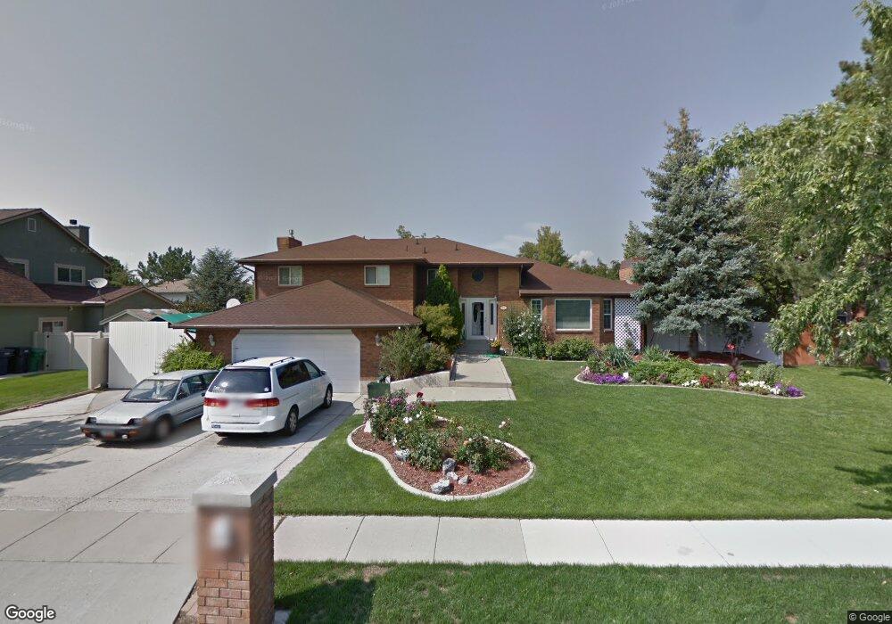
This home is located at 1801 Michael Way, Sandy, UT 84093 and is currently estimated at $868,527, approximately $204 per square foot. 1801 Michael Way is a home located in Salt Lake County with nearby schools including Silver Mesa Elementary School, Albion Middle School, and Hillcrest High School.
Ownership History
Date
Name
Owned For
Owner Type
Purchase Details
Closed on
May 14, 2021
Sold by
Whetton Craig and Whetton Tammy
Bought by
Whetton Craig Thomas and Whetton Family Trust
Current Estimated Value
Purchase Details
Closed on
Oct 21, 2005
Sold by
Massung Larry J and Massung Mary S
Bought by
Whetton Craig T and Whetton Tammy
Home Financials for this Owner
Home Financials are based on the most recent Mortgage that was taken out on this home.
Original Mortgage
$260,000
Outstanding Balance
$138,462
Interest Rate
5.68%
Mortgage Type
Unknown
Estimated Equity
$730,065
Purchase Details
Closed on
Sep 30, 1994
Sold by
Mckay Mark S and Beck Mckay Christine A
Bought by
Massung Larry J and Massung Mary S
Home Financials for this Owner
Home Financials are based on the most recent Mortgage that was taken out on this home.
Original Mortgage
$195,920
Interest Rate
8.58%
Mortgage Type
Seller Take Back
Create a Home Valuation Report for This Property
The Home Valuation Report is an in-depth analysis detailing your home's value as well as a comparison with similar homes in the area
Home Values in the Area
Average Home Value in this Area
Purchase History
| Date | Buyer | Sale Price | Title Company |
|---|---|---|---|
| Whetton Craig Thomas | -- | None Available | |
| Whetton Craig T | -- | Wasatch Title Ins Agency Llc | |
| Massung Larry J | -- | -- |
Source: Public Records
Mortgage History
| Date | Status | Borrower | Loan Amount |
|---|---|---|---|
| Open | Whetton Craig T | $260,000 | |
| Previous Owner | Massung Larry J | $195,920 |
Source: Public Records
Tax History
| Year | Tax Paid | Tax Assessment Tax Assessment Total Assessment is a certain percentage of the fair market value that is determined by local assessors to be the total taxable value of land and additions on the property. | Land | Improvement |
|---|---|---|---|---|
| 2025 | $4,154 | $807,400 | $332,300 | $475,100 |
| 2024 | $4,154 | $778,600 | $319,800 | $458,800 |
| 2023 | $3,472 | $649,700 | $307,500 | $342,200 |
| 2022 | $3,607 | $664,000 | $301,500 | $362,500 |
| 2021 | $3,295 | $516,400 | $239,200 | $277,200 |
| 2020 | $3,260 | $482,100 | $239,200 | $242,900 |
| 2019 | $3,247 | $468,500 | $225,600 | $242,900 |
| 2016 | $2,806 | $391,500 | $203,300 | $188,200 |
Source: Public Records
Map
Nearby Homes
- 8921 S Shady Meadow Dr
- 1891 Richard Rd
- 1482 Waters Ln
- 8857 S Capella Way
- 9472 S Tramway Dr
- 8638 Piper Ln
- 1492 E Sandy Hills Dr
- 2156 E Falcon Way
- 1430 E 8685 S
- 1924 E Viscounti Cove
- 9078 S Daybreak Dr
- 8492 S Mesa Dr
- 1990 E Terra Vista Way
- 1371 Sudbury Ave
- 8483 Terrace Dr
- 8546 S 1330 E
- 2333 Cliff Swallow Dr
- 8411 S 1475 E
- 1138 E Quarry Stone Way
- 8935 Quarry Stone Way
- 1789 E Michael Way
- 1811 Michael Way
- 1789 Michael Way
- 1794 Cameo Way
- 1784 E Cameo Way
- 1784 Cameo Way
- 9003 Ida Ln
- 9003 S Ida Ln
- 9016 Shady Meadow Dr
- 1779 Michael Way
- 1802 E Michael Way
- 9016 S Shady Meadow Dr
- 1802 Michael Way
- 1823 E Michael Way
- 1823 Michael Way
- 1812 Michael Way
- 1774 Cameo Way
- 1774 E Cameo Way
- 1782 Michael Way
- 9002 S Shady Meadow Dr
Your Personal Tour Guide
Ask me questions while you tour the home.