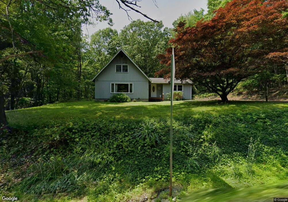
1801 Route 739 Dingmans Ferry, PA 18328
Estimated Value: $231,000 - $257,766
3
Beds
1
Bath
1,836
Sq Ft
$133/Sq Ft
Est. Value
About This Home
This home is located at 1801 Route 739, Dingmans Ferry, PA 18328 and is currently estimated at $244,383, approximately $133 per square foot. 1801 Route 739 is a home located in Pike County with nearby schools including Delaware Valley High School.
Ownership History
Date
Name
Owned For
Owner Type
Purchase Details
Closed on
Apr 15, 2025
Sold by
Corbett James T
Bought by
Corbett Kimberly A
Current Estimated Value
Purchase Details
Closed on
Mar 3, 2025
Sold by
Corbett James T
Bought by
Corbett Kimberly A and Reilly Kimberly A
Purchase Details
Closed on
May 19, 2023
Sold by
Corbett James T
Bought by
Corbett James T
Purchase Details
Closed on
Aug 21, 2017
Sold by
Corbett James T and Corbett Kathleen P
Bought by
Corbett James T and Corbett Kathleen P
Create a Home Valuation Report for This Property
The Home Valuation Report is an in-depth analysis detailing your home's value as well as a comparison with similar homes in the area
Home Values in the Area
Average Home Value in this Area
Purchase History
We collect this data history from publicly available records. To have your information removed, we recommend requesting removal directly through your county’s website.
| Date | Buyer | Sale Price | Title Company |
|---|---|---|---|
| Corbett Kimberly A | -- | -- | |
| Corbett Kimberly A | -- | None Listed On Document | |
| Corbett Kimberly A | -- | None Listed On Document | |
| Corbett James T | -- | -- | |
| Corbett James T | -- | None Available |
Source: Public Records
Tax History
| Year | Tax Paid | Tax Assessment Tax Assessment Total Assessment is a certain percentage of the fair market value that is determined by local assessors to be the total taxable value of land and additions on the property. | Land | Improvement |
|---|---|---|---|---|
| 2026 | $3,588 | $22,350 | $3,380 | $18,970 |
| 2025 | $3,498 | $22,350 | $3,380 | $18,970 |
| 2024 | $3,498 | $22,350 | $3,380 | $18,970 |
| 2023 | $3,403 | $22,350 | $3,380 | $18,970 |
| 2022 | $3,314 | $22,350 | $3,380 | $18,970 |
| 2021 | $3,280 | $22,350 | $3,380 | $18,970 |
| 2020 | $3,280 | $22,350 | $3,380 | $18,970 |
| 2019 | $3,177 | $22,350 | $3,380 | $18,970 |
| 2018 | $3,177 | $22,350 | $3,380 | $18,970 |
| 2017 | $3,116 | $22,350 | $3,380 | $18,970 |
| 2016 | $0 | $22,350 | $3,380 | $18,970 |
| 2014 | -- | $22,350 | $3,380 | $18,970 |
Source: Public Records
Map
Nearby Homes
- Lot 85,86, Lot 85a Blk B-95 S-13
- Lot 33 Primrose Ln
- 116 Ln
- 130 E Lakeview Dr
- 102 Spruce Dr
- 0 Pa-739 Unit PM-114282
- 118 Willow Dr
- Lot 3 Aspen Rd
- 142 Beech Rd
- 157 E Shore Dr
- 192 Aspen Rd
- 106 Woodland Ct
- 0 Pennsylvania 739
- LOT 3 Stone Ridge Rd
- Lot 14 Doolan Rd
- 208 Doolan Rd
- 161 Woodland Dr
- 122 Kitty Harker Rd
- 46 Creek Ln
- 107 Kinsale Ln
- 0 Court 950
- 126 Primrose Ln
- 106 Court 950
- 129 Primrose Ln
- 107 Church Rd
- 108 Palm Dr
- 109 Church Rd
- 122 Primrose Ln
- 104 Palm Dr
- 123 Primrose Ln
- 100 Pepperidge Dr
- 855 Milford Rd
- 0 Old Milford Rd & 739 Unit 21-1241
- 103 Palm Dr
- 118 Primrose Ln
- 107 Palm Dr
- 103 W Ridge Dr
- 49 Palm Dr
- 104 Pepperidge Dr
- 109 Palm Dr
Your Personal Tour Guide
Ask me questions while you tour the home.