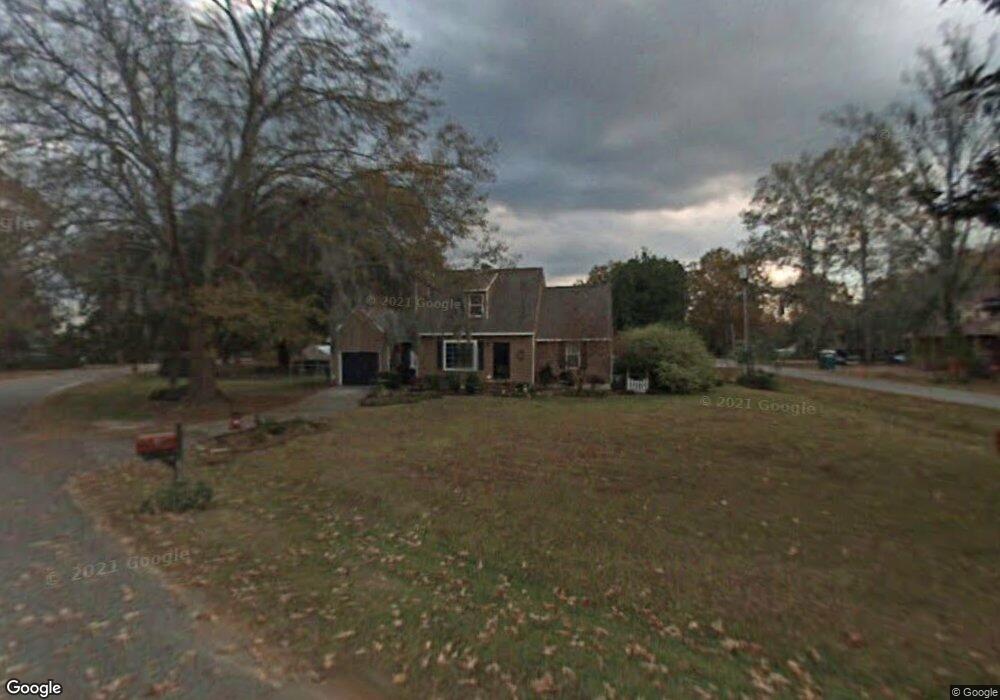
1802 Perch Rd Moncks Corner, SC 29461
Estimated Value: $355,007 - $401,000
3
Beds
3
Baths
1,416
Sq Ft
$262/Sq Ft
Est. Value
About This Home
This home is located at 1802 Perch Rd, Moncks Corner, SC 29461 and is currently estimated at $370,502, approximately $261 per square foot. 1802 Perch Rd is a home located in Berkeley County with nearby schools including Foxbank Elementary School, Berkeley Middle School, and Berkeley High School.
Ownership History
Date
Name
Owned For
Owner Type
Purchase Details
Closed on
Aug 21, 2020
Sold by
Blackwell Robert G and Blackwell Sarah Nell
Bought by
Blackwell Robert G and Blackwell Sarah Nell
Current Estimated Value
Home Financials for this Owner
Home Financials are based on the most recent Mortgage that was taken out on this home.
Original Mortgage
$35,000
Outstanding Balance
$29,668
Interest Rate
2.8%
Mortgage Type
Credit Line Revolving
Estimated Equity
$340,834
Purchase Details
Closed on
Apr 30, 2010
Sold by
Forsling Karen E
Bought by
Blackwell Robert G and Boyce Sarah Nell
Home Financials for this Owner
Home Financials are based on the most recent Mortgage that was taken out on this home.
Original Mortgage
$157,102
Outstanding Balance
$107,592
Interest Rate
5.5%
Mortgage Type
FHA
Estimated Equity
$262,910
Purchase Details
Closed on
Aug 27, 2001
Sold by
Allen Christopher G and Allen Ava C
Bought by
Forsling Karen E
Create a Home Valuation Report for This Property
The Home Valuation Report is an in-depth analysis detailing your home's value as well as a comparison with similar homes in the area
Purchase History
| Date | Buyer | Sale Price | Title Company |
|---|---|---|---|
| Blackwell Robert G | -- | Weeks & Irvine Llc | |
| Blackwell Robert G | $160,000 | -- | |
| Forsling Karen E | $122,500 | -- |
Source: Public Records
Mortgage History
| Date | Status | Borrower | Loan Amount |
|---|---|---|---|
| Open | Blackwell Robert G | $35,000 | |
| Open | Blackwell Robert G | $157,102 |
Source: Public Records
Tax History
| Year | Tax Paid | Tax Assessment Tax Assessment Total Assessment is a certain percentage of the fair market value that is determined by local assessors to be the total taxable value of land and additions on the property. | Land | Improvement |
|---|---|---|---|---|
| 2025 | $1,090 | $222,410 | $47,429 | $174,981 |
| 2024 | $1,019 | $8,896 | $1,897 | $6,999 |
| 2023 | $1,019 | $8,896 | $1,897 | $6,999 |
| 2022 | $1,023 | $7,736 | $1,800 | $5,936 |
| 2021 | $3,279 | $7,740 | $1,800 | $5,936 |
| 2020 | $1,060 | $7,736 | $1,800 | $5,936 |
| 2019 | $1,053 | $7,736 | $1,800 | $5,936 |
| 2018 | $981 | $6,732 | $1,600 | $5,132 |
| 2017 | $941 | $6,732 | $1,600 | $5,132 |
| 2016 | $962 | $6,730 | $1,600 | $5,130 |
| 2015 | $893 | $6,730 | $1,600 | $5,130 |
| 2014 | $880 | $6,730 | $1,600 | $5,130 |
| 2013 | -- | $6,730 | $1,600 | $5,130 |
Source: Public Records
Map
Nearby Homes
- 2015 Albert Storm Ave
- 0 Point Comfort Rd Unit 24030382
- 0 Point Comfort Rd Unit 24030383
- 0 Point Comfort Rd Unit 24028043
- 1811 Teal Rd
- 1822 Mallard Cir
- 1629 Pimlico Blvd
- 1004 Magnolia Ln
- 214 Osprey Dr
- 00 Gertie Ln
- 134 Gertie Ln
- 0 Gertie Ln
- 153 Willow Brook Way
- 258 Truth Way
- 266 Oglethorpe Cir
- 143 Dixon Ln
- 223 Everwood Ct
- 415 Black Horse Rd
- 415 Camellia Bloom Dr
- 601 Winter Wren Way
- 1812 Albert Storm Ave
- 1801 Perch Rd
- 1810 Albert Storm Ave
- 1803 Perch Rd
- 1815 Albert Storm Ave
- 1902 Albert Storm Ave
- 1901 Albert Storm Ave
- 1807 Perch Rd
- 1810 Perch Rd
- 1809 Perch Rd
- 1808 Albert Storm Ave
- 1903 Albert Storm Ave
- 1904 Albert Storm Ave
- 1809 Albert Storm Ave
- 1905 Albert Storm Ave
- 1811 Perch Rd
- 1913 Rock Fish Rd
- 1915 Rock Fish Rd
- 1812 Perch Rd
- 1911 Rock Fish Rd
Your Personal Tour Guide
Ask me questions while you tour the home.