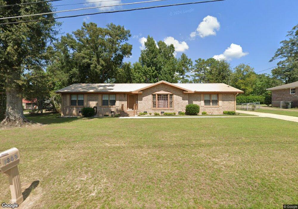
1803 Adrian Rd Dothan, AL 36303
Estimated Value: $165,473 - $212,000
Studio
2
Baths
2,064
Sq Ft
$91/Sq Ft
Est. Value
About This Home
This home is located at 1803 Adrian Rd, Dothan, AL 36303 and is currently estimated at $188,618, approximately $91 per square foot. 1803 Adrian Rd is a home located in Houston County with nearby schools including Dothan City Early Education Center, Dothan 6th Grade Center, and Girard Elementary School.
Ownership History
Date
Name
Owned For
Owner Type
Purchase Details
Closed on
Jul 28, 2021
Sold by
Gilbert Willie Lane
Bought by
Gilbert Willie Lane and Gilbert Jeffrey
Current Estimated Value
Purchase Details
Closed on
Mar 12, 2019
Sold by
Lane Gilbert Willie
Bought by
Lane Gilbert Willie and Gilbert Jeffrey
Purchase Details
Closed on
Feb 22, 2019
Sold by
Gilbert Willie Lane
Bought by
Gilbert Willie Lane and Gilbert Jeffrey
Purchase Details
Closed on
Sep 11, 2012
Sold by
Gilbert Willie Lane
Bought by
Gilbert Willie Lane and Gilbert Diane
Purchase Details
Closed on
Jul 3, 2012
Sold by
Woodham Thomas H
Bought by
Gilbert Willie Lane
Home Financials for this Owner
Home Financials are based on the most recent Mortgage that was taken out on this home.
Original Mortgage
$86,896
Interest Rate
3.76%
Mortgage Type
New Conventional
Purchase Details
Closed on
Nov 21, 2011
Sold by
Woodham Thomas H and Nichols Patty J
Bought by
Woodham Thomas H
Create a Home Valuation Report for This Property
The Home Valuation Report is an in-depth analysis detailing your home's value as well as a comparison with similar homes in the area
Purchase History
| Date | Buyer | Sale Price | Title Company |
|---|---|---|---|
| Gilbert Willie Lane | -- | None Available | |
| Lane Gilbert Willie | -- | None Available | |
| Gilbert Willie Lane | -- | None Available | |
| Gilbert Willie Lane | -- | -- | |
| Gilbert Willie Lane | -- | -- | |
| Woodham Thomas H | -- | -- |
Source: Public Records
Mortgage History
| Date | Status | Borrower | Loan Amount |
|---|---|---|---|
| Previous Owner | Woodham Thomas H | $86,896 |
Source: Public Records
Tax History
| Year | Tax Paid | Tax Assessment Tax Assessment Total Assessment is a certain percentage of the fair market value that is determined by local assessors to be the total taxable value of land and additions on the property. | Land | Improvement |
|---|---|---|---|---|
| 2025 | $472 | $14,640 | $0 | $0 |
| 2024 | $472 | $13,940 | $0 | $0 |
| 2023 | $447 | $12,620 | $0 | $0 |
| 2022 | $348 | $11,600 | $0 | $0 |
| 2021 | $318 | $11,940 | $0 | $0 |
| 2020 | $314 | $10,620 | $0 | $0 |
| 2018 | $305 | $10,360 | $0 | $0 |
| 2017 | $325 | $10,920 | $0 | $0 |
| 2016 | $325 | $0 | $0 | $0 |
| 2015 | $325 | $0 | $0 | $0 |
| 2014 | $325 | $0 | $0 | $0 |
Source: Public Records
Map
Nearby Homes
- 107 Shawnee Ct
- 409 Sequoyah Dr
- 207 Seeba Dr
- 203 Aspen Cir
- 1507 Catalina Dr
- 1638 Denton Rd
- 1404 Hiawatha Dr
- 204 Aspen Cir
- 1906 Sullivan Dr
- 408 Rebecca Ave
- 1500 Denton Rd
- 1922 Sullivan Dr
- 1804 Azure Dr
- 1219 Sturgeon Ct
- 1702 Impala Dr
- 2102 Centenial Dr
- 1904 Azure Dr
- 1504 Sioux St
- 1309 Sioux St
- 1002 Winchester Cir
- 1805 Adrian Rd
- 1700 Woodsvale Dr
- 1505 Randall Rd
- 1507 Randall Rd
- 1901 Adrian Rd
- 1800 Adrian Rd
- 0 Woodsvale Dr
- 1900 Adrian Rd
- 1703 Woodsvale Dr
- 1701 Woodsvale Dr
- 1903 Adrian Rd
- 1606 Woodsvale Dr
- 102 April Cir
- 1501 Randall Rd
- 1601 Randall Rd
- 1500 Randall Rd
- 1504 Randall Rd
- 1506 Randall Rd
- 1743 Denton Rd
- 104 April Cir
Your Personal Tour Guide
Ask me questions while you tour the home.