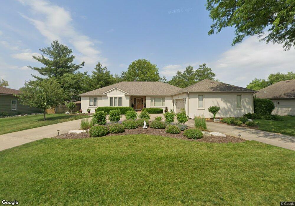
1803 W Bob o Link Dr Pontiac, IL 61764
Estimated Value: $333,000 - $391,454
3
Beds
4
Baths
2,861
Sq Ft
$129/Sq Ft
Est. Value
About This Home
This home is located at 1803 W Bob o Link Dr, Pontiac, IL 61764 and is currently estimated at $369,864, approximately $129 per square foot. 1803 W Bob o Link Dr is a home located in Livingston County with nearby schools including Central Elementary School, Lincoln Elementary School, and Washington Elementary School.
Ownership History
Date
Name
Owned For
Owner Type
Purchase Details
Closed on
Dec 9, 2021
Sold by
Schuler Susan Kay
Bought by
Dodson Patty Jo and Dodson Berley Albert
Current Estimated Value
Home Financials for this Owner
Home Financials are based on the most recent Mortgage that was taken out on this home.
Original Mortgage
$125,000
Outstanding Balance
$114,936
Interest Rate
3.09%
Mortgage Type
New Conventional
Estimated Equity
$254,928
Purchase Details
Closed on
Mar 23, 2018
Sold by
Pinkerton Terry M
Bought by
Schuler Susan Kay
Create a Home Valuation Report for This Property
The Home Valuation Report is an in-depth analysis detailing your home's value as well as a comparison with similar homes in the area
Home Values in the Area
Average Home Value in this Area
Purchase History
| Date | Buyer | Sale Price | Title Company |
|---|---|---|---|
| Dodson Patty Jo | $325,000 | None Available | |
| Schuler Susan Kay | -- | None Available |
Source: Public Records
Mortgage History
| Date | Status | Borrower | Loan Amount |
|---|---|---|---|
| Open | Dodson Patty Jo | $125,000 |
Source: Public Records
Tax History Compared to Growth
Tax History
| Year | Tax Paid | Tax Assessment Tax Assessment Total Assessment is a certain percentage of the fair market value that is determined by local assessors to be the total taxable value of land and additions on the property. | Land | Improvement |
|---|---|---|---|---|
| 2024 | $9,898 | $113,047 | $14,833 | $98,214 |
| 2023 | $9,605 | $105,751 | $13,876 | $91,875 |
| 2022 | $9,065 | $96,143 | $13,876 | $82,267 |
| 2021 | $2,894 | $92,445 | $13,342 | $79,103 |
| 2020 | $2,894 | $89,666 | $12,941 | $76,725 |
| 2019 | $2,541 | $85,739 | $12,374 | $73,365 |
| 2018 | $2,774 | $89,079 | $12,499 | $76,580 |
| 2017 | $8,205 | $88,990 | $12,487 | $76,503 |
| 2016 | $8,173 | $89,292 | $12,639 | $76,653 |
| 2015 | $8,046 | $89,292 | $12,639 | $76,653 |
| 2013 | $8,384 | $96,622 | $13,545 | $83,077 |
Source: Public Records
Map
Nearby Homes
- 1810 Cardinal Ct
- 1620 Meadowlark Dr
- 1635 Mockingbird Ln
- 13301 E 1875 North Rd
- 1304 W Reynolds St
- 1204 W Reynolds St
- 406 Carol Ct Unit B2
- 105 Carol Ct Unit C-1
- 113 Park Estate Ave
- 2 W Edgewood Dr
- 606 N Ladd St
- 34 Westwood Ave
- 811 W South St
- 618 W Sherman Ave
- Lot 3 W Cleary St
- Lot 14 W Sherman Ave
- 721 W South St
- 734 W Henry St
- 503 W Livingston St
- 19097 1330 Rd E
- 1803 Bob o Link St
- 1801 W Bob o Link Dr
- 1805 W Bob o Link Dr
- 1809 W Bob o Link Dr
- 1712 W Meadowlark Dr
- 1807 Bob o Link St
- 1807 W Bob o Link Dr
- 1708 W Meadowlark Dr
- 1802 W Bob o Link Dr
- 1804 W Bob o Link Dr
- 1806 W Bob o Link Dr
- 1809 Bob-0-link Dr
- 1701 W Meadowlark Dr
- 1713 W Meadowlark Dr
- 1703 W Meadowlark Dr
- 1705 W Meadowlark Dr
- 1700 W Meadowlark Dr
- 1702 W Meadowlark Dr
- 1704 W Meadowlark Dr
- 1710 W Meadowlark Dr