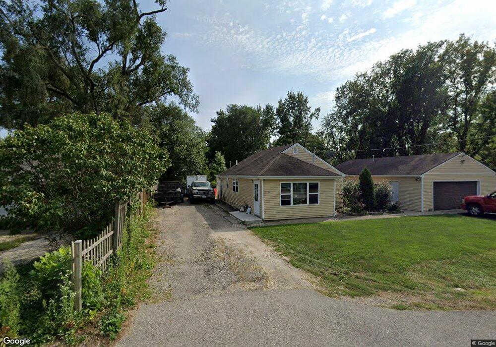
1803 W Davis Ave McHenry, IL 60050
Burtons Bridge NeighborhoodEstimated Value: $175,000 - $240,000
2
Beds
3
Baths
1,008
Sq Ft
$212/Sq Ft
Est. Value
About This Home
This home is located at 1803 W Davis Ave, McHenry, IL 60050 and is currently estimated at $213,670, approximately $211 per square foot. 1803 W Davis Ave is a home located in McHenry County with nearby schools including Prairie Grove Elementary School, Prairie Grove Junior High School, and Prairie Ridge High School.
Ownership History
Date
Name
Owned For
Owner Type
Purchase Details
Closed on
Nov 16, 2016
Sold by
Federal National Mortgage Association
Bought by
Perez Santos Eduardo F
Current Estimated Value
Home Financials for this Owner
Home Financials are based on the most recent Mortgage that was taken out on this home.
Original Mortgage
$182,746
Outstanding Balance
$116,863
Interest Rate
3.37%
Mortgage Type
New Conventional
Estimated Equity
$96,807
Purchase Details
Closed on
Aug 26, 2016
Sold by
Baxter Credit Union
Bought by
Federal National Mortgage Association
Create a Home Valuation Report for This Property
The Home Valuation Report is an in-depth analysis detailing your home's value as well as a comparison with similar homes in the area
Home Values in the Area
Average Home Value in this Area
Purchase History
| Date | Buyer | Sale Price | Title Company |
|---|---|---|---|
| Perez Santos Eduardo F | $80,000 | First American Title | |
| Federal National Mortgage Association | -- | None Available |
Source: Public Records
Mortgage History
| Date | Status | Borrower | Loan Amount |
|---|---|---|---|
| Open | Perez Santos Eduardo F | $182,746 |
Source: Public Records
Tax History
| Year | Tax Paid | Tax Assessment Tax Assessment Total Assessment is a certain percentage of the fair market value that is determined by local assessors to be the total taxable value of land and additions on the property. | Land | Improvement |
|---|---|---|---|---|
| 2024 | $2,652 | $41,227 | $6,950 | $34,277 |
| 2023 | $2,564 | $36,972 | $6,233 | $30,739 |
| 2022 | $2,534 | $33,811 | $5,700 | $28,111 |
| 2021 | $2,360 | $31,700 | $5,344 | $26,356 |
| 2020 | $2,314 | $30,750 | $5,184 | $25,566 |
| 2019 | $2,235 | $29,236 | $4,929 | $24,307 |
| 2018 | $1,206 | $18,416 | $4,629 | $13,787 |
| 2017 | $1,159 | $17,643 | $4,435 | $13,208 |
| 2016 | $1,120 | $16,833 | $4,231 | $12,602 |
| 2013 | $815 | $21,837 | $4,026 | $17,811 |
Source: Public Records
Map
Nearby Homes
- 000 Carman Ave S
- 3003 Keene Ave
- Lot 5 Tower Dr
- Lot 20 Holiday Dr
- 1509 W Pine St
- 2509 S Birchwood Ave
- 2510 S Birchwood Ave
- 1903 Lands Ct
- 1041 Wimbledon Dr
- 2215 Crystal Cir
- 3727 Hale Ln Unit 9
- 727 Nantucket Way Unit 1
- 588 Nantucket Way Unit 2
- 4126 Wildwood Dr
- 720 Tulip Cir
- 4107 Niblick Ct
- 4101 Niblick Ct
- 4113 Niblick Ct
- 404 Lauren Ln
- 4024 Newport Dr
- 1803 W Davis Ave
- 1820 Low Ave
- 3003 S Riverside Dr
- 3001 S Riverside Dr
- 3005 S Riverside Dr
- 1810 W Davis Ave
- 3009 S Riverside Dr
- 1804 W Davis Ave
- 2911 S Riverside Dr
- 2911 S Riverside Dr
- 3007 Carman Ave
- 2911 Carman Ave
- 2911 Carman Ave
- 3008 S Riverside Dr
- 1805 Low Ave
- 1803 Surf St
- 1807 Low Ave
- 2907 S Riverside Dr
- 1755 Low Ave
- 2918 S Riverside Dr
Your Personal Tour Guide
Ask me questions while you tour the home.