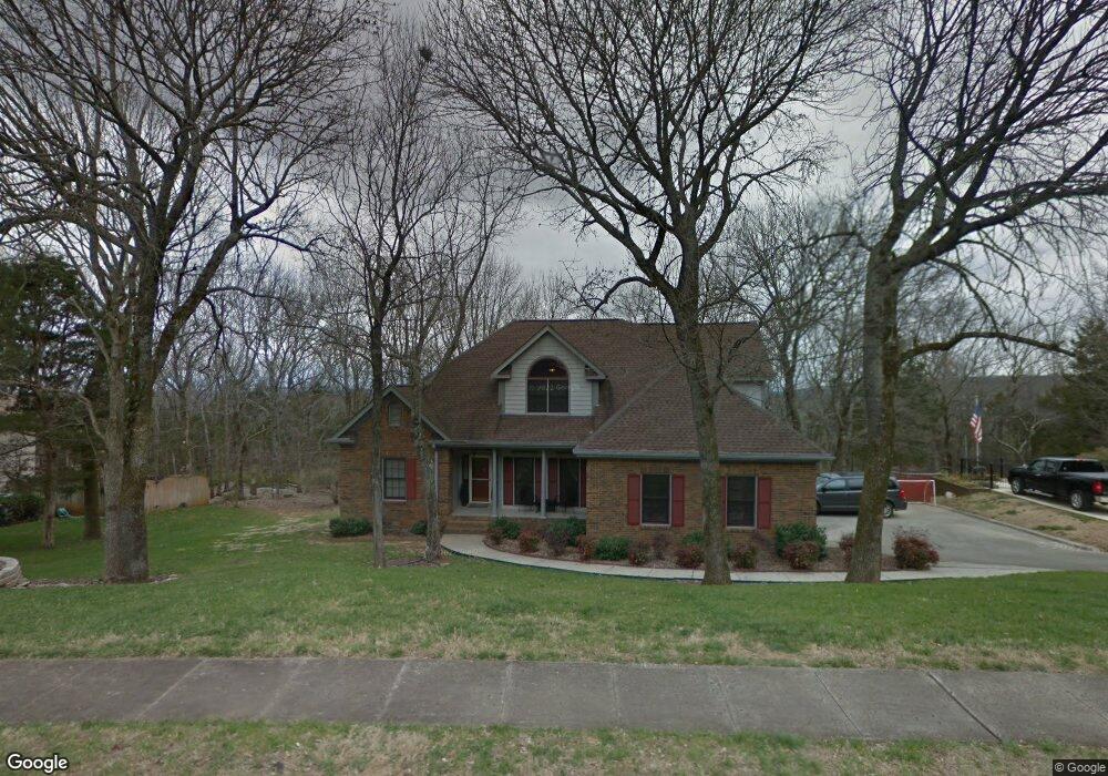
1805 Gaslight Way NE Huntsville, AL 35801
Blossomwood NeighborhoodEstimated Value: $523,334 - $612,000
--
Bed
1
Bath
2,989
Sq Ft
$189/Sq Ft
Est. Value
About This Home
This home is located at 1805 Gaslight Way NE, Huntsville, AL 35801 and is currently estimated at $564,584, approximately $188 per square foot. 1805 Gaslight Way NE is a home with nearby schools including Chapman Elementary School, Chapman Middle School, and Lee High School.
Ownership History
Date
Name
Owned For
Owner Type
Purchase Details
Closed on
Sep 29, 2005
Sold by
Mcalpine Johnny W and Mcalpine Helen T
Bought by
Condron Patrick J and Condron Stacey
Current Estimated Value
Home Financials for this Owner
Home Financials are based on the most recent Mortgage that was taken out on this home.
Original Mortgage
$160,000
Outstanding Balance
$85,099
Interest Rate
5.66%
Mortgage Type
New Conventional
Estimated Equity
$479,485
Create a Home Valuation Report for This Property
The Home Valuation Report is an in-depth analysis detailing your home's value as well as a comparison with similar homes in the area
Home Values in the Area
Average Home Value in this Area
Purchase History
| Date | Buyer | Sale Price | Title Company |
|---|---|---|---|
| Condron Patrick J | -- | -- |
Source: Public Records
Mortgage History
| Date | Status | Borrower | Loan Amount |
|---|---|---|---|
| Open | Condron Patrick J | $160,000 |
Source: Public Records
Tax History Compared to Growth
Tax History
| Year | Tax Paid | Tax Assessment Tax Assessment Total Assessment is a certain percentage of the fair market value that is determined by local assessors to be the total taxable value of land and additions on the property. | Land | Improvement |
|---|---|---|---|---|
| 2024 | $2,605 | $45,740 | $4,760 | $40,980 |
| 2023 | $2,605 | $43,640 | $4,760 | $38,880 |
| 2022 | $2,316 | $40,760 | $4,260 | $36,500 |
| 2021 | $2,061 | $36,360 | $4,260 | $32,100 |
| 2020 | $2,061 | $36,340 | $4,250 | $32,090 |
| 2019 | $2,001 | $35,300 | $4,250 | $31,050 |
| 2018 | $1,915 | $33,840 | $0 | $0 |
| 2017 | $1,795 | $31,780 | $0 | $0 |
| 2016 | $1,795 | $31,780 | $0 | $0 |
| 2015 | $1,795 | $31,780 | $0 | $0 |
| 2014 | $1,715 | $30,400 | $0 | $0 |
Source: Public Records
Map
Nearby Homes
- 2407 Bankhead Pkwy NE
- 2312 Oakwood Ave NE
- 2014 Chambers Dr NE
- 2018 Polk Dr NE
- 2033 Dellbrook Dr NE
- 2011 Wooddale Dr NE
- 2212 Toll Gate Rd SE
- 117 Knollridge Dr
- 508 Owens Dr SE
- 2200 Isabelle Cir NE
- 2206 Toll Gate Rd SE
- 1719 Oakwood Ave NE
- 211 Knollridge Cir SE
- 213 Knollridge Cir SE
- 2204 Toll Gate Rd SE
- 700 Fagan Springs Dr SE
- 1712 Wakefield Dr NE
- 103 Dill St SE
- 905 Stevens Ct NE
- 2815 Talon Cir
- 2307 Appletree Ct NE
- 1807 Gaslight Way NE
- 1804 Gaslight Way NE
- 1802 Gaslight Way NE
- 1809 Gaslight Way NE
- 2303 Appletree Ct NE
- 110 Sandusky St NE
- 2401 Hayleys Way NE
- 106 Sandusky St NE
- 1800 Gaslight Way NE
- 1801 Gaslight Way NE
- 114 Sandusky St NE
- 2304 Appletree Ct NE
- 112 Sandusky St NE
- 1811 Gaslight Way NE
- 2301 Appletree Ct NE
- 2302 Appletree Ct NE
- 0 NE Sandusky St
- LOT 23 Sandusky Dr NE
- LOT 22 Sandusky Dr NE