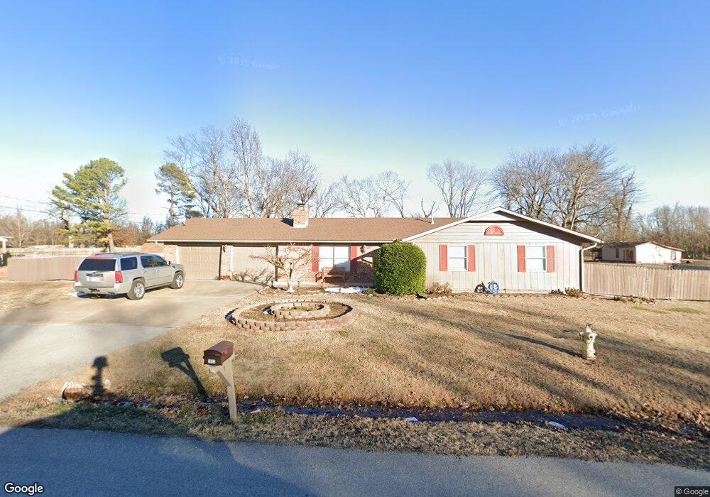
1805 Mayflower Rd Bentonville, AR 72712
Estimated Value: $439,318 - $496,000
--
Bed
2
Baths
1,937
Sq Ft
$247/Sq Ft
Est. Value
About This Home
This home is located at 1805 Mayflower Rd, Bentonville, AR 72712 and is currently estimated at $477,580, approximately $246 per square foot. 1805 Mayflower Rd is a home located in Benton County with nearby schools including Mary Mae Jones Elementary School, Ruth Barker Middle School, and Fulbright Junior High School.
Ownership History
Date
Name
Owned For
Owner Type
Purchase Details
Closed on
Jul 5, 2010
Bought by
City Of Bentonville
Current Estimated Value
Purchase Details
Closed on
Sep 1, 1999
Bought by
Macdonald
Purchase Details
Closed on
Aug 22, 1989
Bought by
Rumancik
Purchase Details
Closed on
Jan 28, 1985
Bought by
Jr Lee
Purchase Details
Closed on
Aug 15, 1983
Bought by
Evers
Create a Home Valuation Report for This Property
The Home Valuation Report is an in-depth analysis detailing your home's value as well as a comparison with similar homes in the area
Home Values in the Area
Average Home Value in this Area
Purchase History
| Date | Buyer | Sale Price | Title Company |
|---|---|---|---|
| City Of Bentonville | -- | -- | |
| Macdonald | $125,000 | -- | |
| Rumancik | $78,000 | -- | |
| Jr Lee | $67,000 | -- | |
| Evers | -- | -- |
Source: Public Records
Tax History Compared to Growth
Tax History
| Year | Tax Paid | Tax Assessment Tax Assessment Total Assessment is a certain percentage of the fair market value that is determined by local assessors to be the total taxable value of land and additions on the property. | Land | Improvement |
|---|---|---|---|---|
| 2025 | $1,989 | $69,292 | $15,300 | $53,992 |
| 2024 | $1,998 | $69,292 | $15,300 | $53,992 |
| 2023 | $1,998 | $48,210 | $9,590 | $38,620 |
| 2022 | $1,671 | $48,210 | $9,590 | $38,620 |
| 2021 | $1,665 | $48,210 | $9,590 | $38,620 |
| 2020 | $1,684 | $37,260 | $5,710 | $31,550 |
| 2019 | $1,602 | $37,260 | $5,710 | $31,550 |
| 2018 | $1,545 | $37,260 | $5,710 | $31,550 |
| 2017 | $1,326 | $37,260 | $5,710 | $31,550 |
| 2016 | $1,326 | $37,260 | $5,710 | $31,550 |
| 2015 | $1,599 | $25,880 | $4,900 | $20,980 |
| 2014 | $1,249 | $24,410 | $4,900 | $19,510 |
Source: Public Records
Map
Nearby Homes
- 1711 Mayflower Rd
- 1904 Mayflower Rd
- 1500 Mayflower Rd
- 2500 SW Moorland St
- 2503 SW Moorland St
- 1903 SW Birch St
- 2400 SW I St
- 0 SW I St Unit 1317853
- 1902 SW Sequoia St
- 1800 SW Sequoia St
- 2101 SW 20th St
- 1900 SW Aspen St
- 1900 SW Aspeen St
- 1203 SW I St
- 2302 SW 15th St
- 1201 & 1203 SW I St
- 2310 SW 17th St
- 1801 SW E St
- 2402 SW 17th St
- 1901 SW Columbus Rd
- 1803 Mayflower Rd
- 1807 Mayflower Rd
- 1804 Mayflower Rd
- 1809 Mayflower Rd
- 1710 Mayflower Rd
- 1802 Mayflower Rd
- 1709 Mayflower Rd
- 1808 Mayflower Rd
- 1708 Mayflower Rd
- 1903 Mayflower Rd
- 1707 Mayflower Rd
- 1706 Mayflower Rd
- 1902 Mayflower Rd
- 1701 Mayflower Rd
- 1607 Mayflower Rd
- 1606 Mayflower Rd
- 2400 SW Coniferous Place
- 1605 Mayflower Rd
- 2400 SW Surrey Ave
- 2401 SW Coniferous Place