

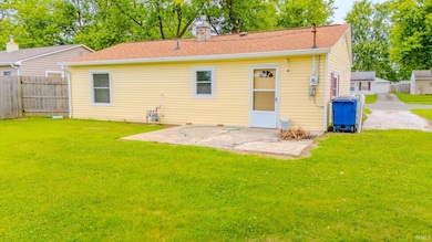


1805 W Wenlock Dr Marion, IN 46952
Sunnywest NeighborhoodEstimated payment $662/month
Highlights
- Porch
- Walk-In Closet
- Tile Flooring
- Double Pane Windows
- Patio
- 5-minute walk to Sunnycrest Park
About This Home
Welcome to this charming move-in ready bungalow offering 2 bedrooms and 1 bathroom. The home features a spacious living room, a functional galley kitchen, and a primary bedroom with a walk-in closet. Recent updates include a newer roof, siding, furnace, and AC, giving you peace of mind. Enjoy the open front porch & patio areas. With its comfortable layout and big ticket updates, this home is ready for its next owner.
Listing Agent
Howell Realty Group, LLC Brokerage Phone: 765-506-0010 Listed on: 07/28/2025
Home Details
Home Type
- Single Family
Est. Annual Taxes
- $733
Year Built
- Built in 1963
Lot Details
- 7,405 Sq Ft Lot
- Lot Dimensions are 118.3x61
- Partially Fenced Property
- Privacy Fence
- Level Lot
- Property is zoned R2
Parking
- Gravel Driveway
Home Design
- Slab Foundation
- Poured Concrete
- Shingle Roof
- Vinyl Construction Material
Interior Spaces
- 1-Story Property
- Ceiling Fan
- Double Pane Windows
Kitchen
- Electric Oven or Range
- Laminate Countertops
Flooring
- Carpet
- Laminate
- Tile
Bedrooms and Bathrooms
- 2 Bedrooms
- Walk-In Closet
- 1 Full Bathroom
Laundry
- Laundry on main level
- Washer and Electric Dryer Hookup
Outdoor Features
- Patio
- Porch
Location
- Suburban Location
Schools
- Kendall/Justice Elementary School
- Mcculloch/Justice Middle School
- Marion High School
Utilities
- Forced Air Heating and Cooling System
- Heating System Uses Gas
Community Details
- Westlea Subdivision
Listing and Financial Details
- Assessor Parcel Number 27-03-36-304-148.000-023
Map
Home Values in the Area
Average Home Value in this Area
Tax History
| Year | Tax Paid | Tax Assessment Tax Assessment Total Assessment is a certain percentage of the fair market value that is determined by local assessors to be the total taxable value of land and additions on the property. | Land | Improvement |
|---|---|---|---|---|
| 2024 | $733 | $84,700 | $14,300 | $70,400 |
| 2023 | $590 | $76,400 | $14,300 | $62,100 |
| 2022 | $490 | $66,700 | $12,600 | $54,100 |
| 2021 | $443 | $59,900 | $12,600 | $47,300 |
| 2020 | $353 | $54,600 | $12,600 | $42,000 |
| 2019 | $330 | $54,300 | $12,600 | $41,700 |
| 2018 | $270 | $50,200 | $12,600 | $37,600 |
| 2017 | $262 | $50,500 | $12,600 | $37,900 |
| 2016 | $227 | $47,900 | $13,900 | $34,000 |
| 2014 | $234 | $49,200 | $13,900 | $35,300 |
| 2013 | $234 | $49,200 | $13,900 | $35,300 |
Property History
| Date | Event | Price | List to Sale | Price per Sq Ft |
|---|---|---|---|---|
| 11/03/2025 11/03/25 | Pending | -- | -- | -- |
| 08/28/2025 08/28/25 | Price Changed | $114,000 | -4.1% | $134 / Sq Ft |
| 07/28/2025 07/28/25 | For Sale | $118,900 | -- | $140 / Sq Ft |
Purchase History
| Date | Type | Sale Price | Title Company |
|---|---|---|---|
| Warranty Deed | -- | None Available | |
| Deed | $134,500 | -- |
Mortgage History
| Date | Status | Loan Amount | Loan Type |
|---|---|---|---|
| Open | $54,051 | FHA |
Source: Indiana Regional MLS
MLS Number: 202529539
APN: 27-03-36-304-148.000-023
Disclaimer: Certain information contained herein is derived from information provided by parties other than Homes.com. All information provided is deemed reliable, but is not guaranteed to be accurate and should be independently verified.
![]() IDX information is provided exclusively for personal, non-commercial use, and may not be used for any purpose other than to identify prospective properties consumers may be interested in purchasing. Information is deemed reliable but not guaranteed.
IDX information is provided exclusively for personal, non-commercial use, and may not be used for any purpose other than to identify prospective properties consumers may be interested in purchasing. Information is deemed reliable but not guaranteed.
- 601 N Bradner Ave
- 1807 W Wenlock Dr
- 940 N Park Ave
- 502 N Lenfesty Ave
- 304 N Norton Ave
- 1807 W Westlea Dr
- 2200 W 2nd St
- 1436 W Spencer Ave
- 1512 W Spencer Ave
- 1101 W Riga Ave
- 1534 W 2nd St
- 1018 N Lincolnshire Blvd
- 1032 W Brandon Ave
- 303 S Lenfesty Ave
- 1109 W Riga Ave
- 1203 W National Ave
- 1005 N Oxford Dr
- 1406 Fox Trail Unit 30
- 1404 Fox Trail Unit 31
- 1309 W 1st St
