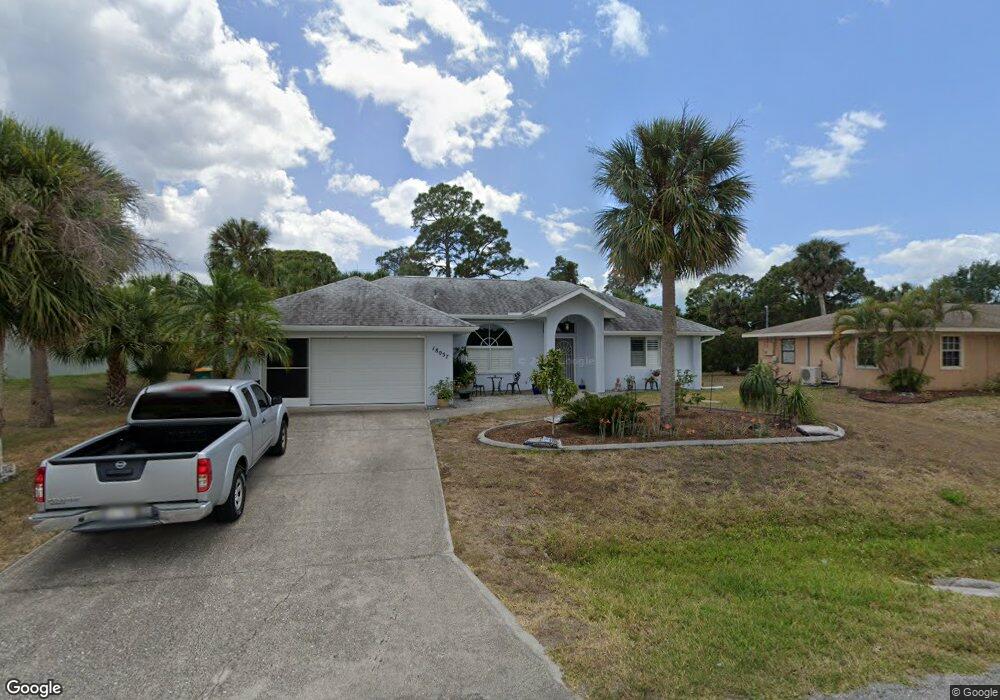
18057 Legrand Ave Port Charlotte, FL 33948
Estimated Value: $294,060 - $400,000
4
Beds
3
Baths
1,924
Sq Ft
$173/Sq Ft
Est. Value
About This Home
This home is located at 18057 Legrand Ave, Port Charlotte, FL 33948 and is currently estimated at $332,265, approximately $172 per square foot. 18057 Legrand Ave is a home located in Charlotte County with nearby schools including Meadow Park Elementary School, Murdock Middle School, and Port Charlotte High School.
Ownership History
Date
Name
Owned For
Owner Type
Purchase Details
Closed on
Jun 19, 2015
Sold by
Shea John R and Shea Jean
Bought by
Shea John R and Shea Jean
Current Estimated Value
Purchase Details
Closed on
Jul 21, 2003
Sold by
Middlebrook Donna R and Middlebrook Edwin C
Bought by
Sheridan Rebecca
Purchase Details
Closed on
Apr 11, 2003
Sold by
Middlebrook Donna R
Bought by
Middlebrook Edwin C
Purchase Details
Closed on
Feb 26, 2000
Sold by
Mewborne John S and Mewborne Krista A
Bought by
Middlebrook Edwin C and Middlebrook Donna R
Purchase Details
Closed on
Jan 19, 1999
Sold by
Boyer Loie U and Dorr Donna
Bought by
Middlebrook Edwin C and Middlebrook Donna R
Purchase Details
Closed on
Oct 7, 1996
Sold by
Mewborne John S and Mewborne Kristin A
Bought by
Boyer Lole U and Dorr Donna
Purchase Details
Closed on
Apr 11, 1995
Sold by
Tri Sun Bldr Inc
Bought by
Mewborne John S and Mewborne Kristin A
Create a Home Valuation Report for This Property
The Home Valuation Report is an in-depth analysis detailing your home's value as well as a comparison with similar homes in the area
Home Values in the Area
Average Home Value in this Area
Purchase History
| Date | Buyer | Sale Price | Title Company |
|---|---|---|---|
| Shea John R | -- | Attorney | |
| Shea John R | -- | Attorney | |
| Shea John R | $50,000 | Attorney | |
| Sheridan Rebecca | $116,000 | -- | |
| Middlebrook Edwin C | -- | -- | |
| Middlebrook Edwin C | -- | -- | |
| Middlebrook Edwin C | -- | -- | |
| Boyer Lole U | $75,000 | -- | |
| Mewborne John S | $74,900 | -- |
Source: Public Records
Tax History Compared to Growth
Tax History
| Year | Tax Paid | Tax Assessment Tax Assessment Total Assessment is a certain percentage of the fair market value that is determined by local assessors to be the total taxable value of land and additions on the property. | Land | Improvement |
|---|---|---|---|---|
| 2023 | $909 | $101,317 | $0 | $0 |
| 2022 | $861 | $98,366 | $0 | $0 |
| 2021 | $850 | $95,501 | $0 | $0 |
| 2020 | $817 | $94,182 | $0 | $0 |
| 2019 | $751 | $92,065 | $0 | $0 |
| 2018 | $681 | $90,348 | $0 | $0 |
| 2017 | $674 | $88,490 | $0 | $0 |
| 2016 | $652 | $81,518 | $0 | $0 |
| 2015 | $2,028 | $90,217 | $0 | $0 |
| 2014 | $2,159 | $98,644 | $0 | $0 |
Source: Public Records
Map
Nearby Homes
- 4440 Tatum St
- 18020 Ohara Dr
- 4468 Sutlive St
- 18053 Ohara Dr
- 18069 Ohara Dr
- 18037 Ohara Dr
- 18085 Ohara Dr
- 18093 Ohara Dr
- 18053 Cullman Ave
- 4441 Collingswood Blvd
- 18237 Bracken Cir
- 18065 Republic Ave
- 18049 Republic Ave
- 18019 Avonsdale Cir
- 4390 Wischamper St
- 5035 Collingswood Blvd
- 18106 Avonsdale Cir
- 4466 Bayview St
- 18116 Wolbrette Cir
- 18065 Wing Ave
- 18049 Legrand Ave
- 18065 Legrand Ave
- 18041 Legrand Ave
- 18124 Bracken Cir
- 18060 Legrand Ave
- 18048 Legrand Ave
- 18072 Connolly Ave
- 18072 Avenue
- 18033 Legrand Ave
- 18032 Connolly Ave
- 18024 Connolly Ave
- 18057 Connolly Ave
- 4456 Tatum St
- 18049 Connolly Ave
- 18131 Bracken Cir
- 18123 Bracken Cir
- 18025 Legrand Ave
- 18115 Bracken Cir
- 18081 Bracken Cir
- 18096 Bracken Cir