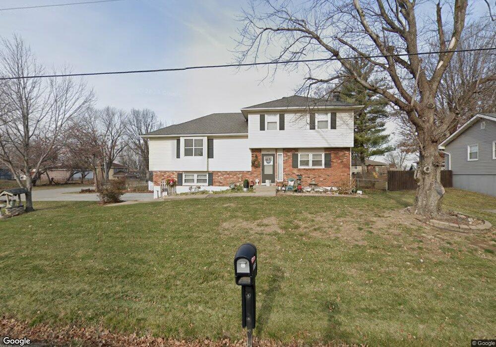
1806 Wornall Rd Excelsior Springs, MO 64024
Estimated Value: $271,018 - $332,000
3
Beds
2
Baths
1,720
Sq Ft
$173/Sq Ft
Est. Value
About This Home
This home is located at 1806 Wornall Rd, Excelsior Springs, MO 64024 and is currently estimated at $297,255, approximately $172 per square foot. 1806 Wornall Rd is a home located in Clay County with nearby schools including Excelsior Springs High School.
Ownership History
Date
Name
Owned For
Owner Type
Purchase Details
Closed on
Jan 10, 2020
Sold by
Saunders Daniel and Saunders Jenece
Bought by
Saunders Daniel and Saunders Jenece
Current Estimated Value
Home Financials for this Owner
Home Financials are based on the most recent Mortgage that was taken out on this home.
Original Mortgage
$72,000
Outstanding Balance
$63,615
Interest Rate
3.6%
Mortgage Type
New Conventional
Estimated Equity
$233,640
Purchase Details
Closed on
Mar 7, 2017
Sold by
Saunders Jenece
Bought by
Saunders Daniel and Saunders Brennan
Purchase Details
Closed on
Jan 13, 2016
Sold by
Offield Nancy E
Bought by
Saunders Jenece L
Create a Home Valuation Report for This Property
The Home Valuation Report is an in-depth analysis detailing your home's value as well as a comparison with similar homes in the area
Home Values in the Area
Average Home Value in this Area
Purchase History
| Date | Buyer | Sale Price | Title Company |
|---|---|---|---|
| Saunders Daniel | -- | None Available | |
| Saunders Daniel | -- | Stewart Title Company | |
| Saunders Daniel | -- | None Available | |
| Saunders Jenece L | -- | None Available |
Source: Public Records
Mortgage History
| Date | Status | Borrower | Loan Amount |
|---|---|---|---|
| Open | Saunders Daniel | $72,000 |
Source: Public Records
Tax History Compared to Growth
Tax History
| Year | Tax Paid | Tax Assessment Tax Assessment Total Assessment is a certain percentage of the fair market value that is determined by local assessors to be the total taxable value of land and additions on the property. | Land | Improvement |
|---|---|---|---|---|
| 2025 | $2,365 | $38,080 | -- | -- |
| 2024 | $2,365 | $33,730 | -- | -- |
| 2023 | $2,351 | $33,730 | $0 | $0 |
| 2022 | $2,094 | $29,560 | $0 | $0 |
| 2021 | $2,102 | $29,564 | $3,800 | $25,764 |
| 2020 | $1,682 | $22,990 | $0 | $0 |
| 2019 | $1,681 | $22,990 | $0 | $0 |
| 2018 | $1,552 | $21,170 | $0 | $0 |
| 2017 | $1,514 | $21,170 | $3,420 | $17,750 |
| 2016 | $1,514 | $21,170 | $3,420 | $17,750 |
| 2015 | $1,528 | $21,170 | $3,420 | $17,750 |
| 2014 | $1,476 | $20,270 | $3,420 | $16,850 |
Source: Public Records
Map
Nearby Homes
- 1904 Karlton Way
- 1908 Lesa Place
- 617 Lodwick Ln
- 609 Kimberly Dr
- 2017 Wornall Rd
- Lot 2 Wornall Rd
- 2017 Karlton Way
- 2081 Rock Bridge Pkwy
- 402 Leslie Ln
- 125 Crown Hill Rd
- 240 Rock Bridge Pkwy
- 00000 NE 144th St
- 2021 Riverstone Dr
- 402 Greenspire St
- 1318 Kristie Cir
- 2207 Ashford St
- 304 Waller Ave
- 106 Helen St
- 332 Woods Ave
- 1101 Williams St
- 1804 Wornall Rd
- 1807 Karlton Way
- 1900 Wornall Rd
- 1805 Karlton Way
- 1802 Wornall Rd
- 417 Lodwick Ln
- 1901 Karlton Way
- 1807 Wornall Rd
- 1803 Karlton Way
- 1902 Wornall Rd
- 1800 Wornall Rd
- 1803 Wornall Rd
- 1903 Karlton Way
- 1801 Karlton Way
- 601 Lodwick Ln
- 415 Lodwick Ln
- 1904 Wornall Rd
- 1720 Wornall Rd
- 600 Zay Dr
- 1905 Karlton Way