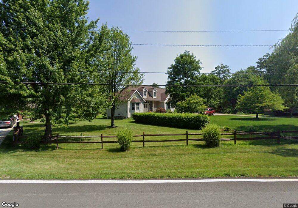
18069 Hunt Rd Strongsville, OH 44136
Estimated Value: $290,000 - $377,829
3
Beds
2
Baths
1,644
Sq Ft
$212/Sq Ft
Est. Value
About This Home
This home is located at 18069 Hunt Rd, Strongsville, OH 44136 and is currently estimated at $348,207, approximately $211 per square foot. 18069 Hunt Rd is a home located in Cuyahoga County with nearby schools including Strongsville High School.
Ownership History
Date
Name
Owned For
Owner Type
Purchase Details
Closed on
Mar 16, 2013
Sold by
Saindon Marilyn A
Bought by
Wellman Marilyn A
Current Estimated Value
Purchase Details
Closed on
May 26, 1989
Sold by
Saindon Paul A
Bought by
Saindon Marilynn A
Purchase Details
Closed on
Sep 10, 1985
Sold by
Fred L Wellman
Bought by
Saindon Paul A
Purchase Details
Closed on
May 11, 1983
Sold by
Fred M Wellman
Bought by
Fred L Wellman
Purchase Details
Closed on
Apr 6, 1983
Sold by
Wellman Fred M
Bought by
Fred M Wellman
Purchase Details
Closed on
Jun 15, 1978
Sold by
Wellman Fred M and Wellman Margt E
Bought by
Wellman Fred M
Purchase Details
Closed on
Jan 1, 1975
Bought by
Wellman Fred M and Wellman Margt E
Create a Home Valuation Report for This Property
The Home Valuation Report is an in-depth analysis detailing your home's value as well as a comparison with similar homes in the area
Home Values in the Area
Average Home Value in this Area
Purchase History
| Date | Buyer | Sale Price | Title Company |
|---|---|---|---|
| Wellman Marilyn A | -- | None Available | |
| Saindon Marilynn A | -- | -- | |
| Saindon Paul A | $19,000 | -- | |
| Fred L Wellman | -- | -- | |
| Fred M Wellman | -- | -- | |
| Wellman Fred M | -- | -- | |
| Wellman Fred M | -- | -- |
Source: Public Records
Tax History Compared to Growth
Tax History
| Year | Tax Paid | Tax Assessment Tax Assessment Total Assessment is a certain percentage of the fair market value that is determined by local assessors to be the total taxable value of land and additions on the property. | Land | Improvement |
|---|---|---|---|---|
| 2024 | $4,971 | $115,675 | $32,480 | $83,195 |
| 2023 | $5,676 | $99,680 | $20,440 | $79,240 |
| 2022 | $5,661 | $99,680 | $20,440 | $79,240 |
| 2021 | $5,617 | $99,680 | $20,440 | $79,240 |
| 2020 | $5,096 | $81,730 | $16,770 | $64,960 |
| 2019 | $4,947 | $233,500 | $47,900 | $185,600 |
| 2018 | $4,490 | $81,730 | $16,770 | $64,960 |
| 2017 | $4,042 | $69,550 | $15,120 | $54,430 |
| 2016 | $4,009 | $69,550 | $15,120 | $54,430 |
| 2015 | $4,066 | $69,550 | $15,120 | $54,430 |
| 2014 | $4,066 | $69,550 | $15,120 | $54,430 |
Source: Public Records
Map
Nearby Homes
- 14558 Drake Rd
- 14132 Walking Stick Way
- 18987 Laurell Cir
- 18229 Howe Rd
- 14985 Camden Cir
- 17130 Golden Star Dr
- 13448 Compass Point Dr
- 14292 Trenton Ave
- 19252 Hidden Woods Ln
- 13335 Tradewinds Dr
- 19297 Hunt Rd
- 19813 Cross Trail S
- 19694 Benbow Rd
- 15188 Trails Landing
- 19740 Benbow Rd
- 15604-REAR Boston Rd
- 15772 Boston Rd
- 16650 Lanier Ave
- 3137 Blackburn Ln
- 16711 Beech Cir
- 18115 Hunt Rd
- 18061 Hunt Rd
- 14663 Walking Stick Way
- 18015 Hunt Rd
- 14122 Panorama Pkwy
- 18159 Hunt Rd
- 14641 Walking Stick Way
- 18110 Hunt Rd
- 17971 Hunt Rd
- 18205 Hunt Rd
- 18004 Hunt Rd
- 14619 Walking Stick Way
- 18135 Stony Point Dr
- 17966 Hunt Rd
- 14658 Walking Stick Way
- 14577 Walking Stick Way
- 18043 Stony Point Dr
- 18223 Hunt Rd
- 18227 Stony Point Dr
- 17932 Hunt Rd