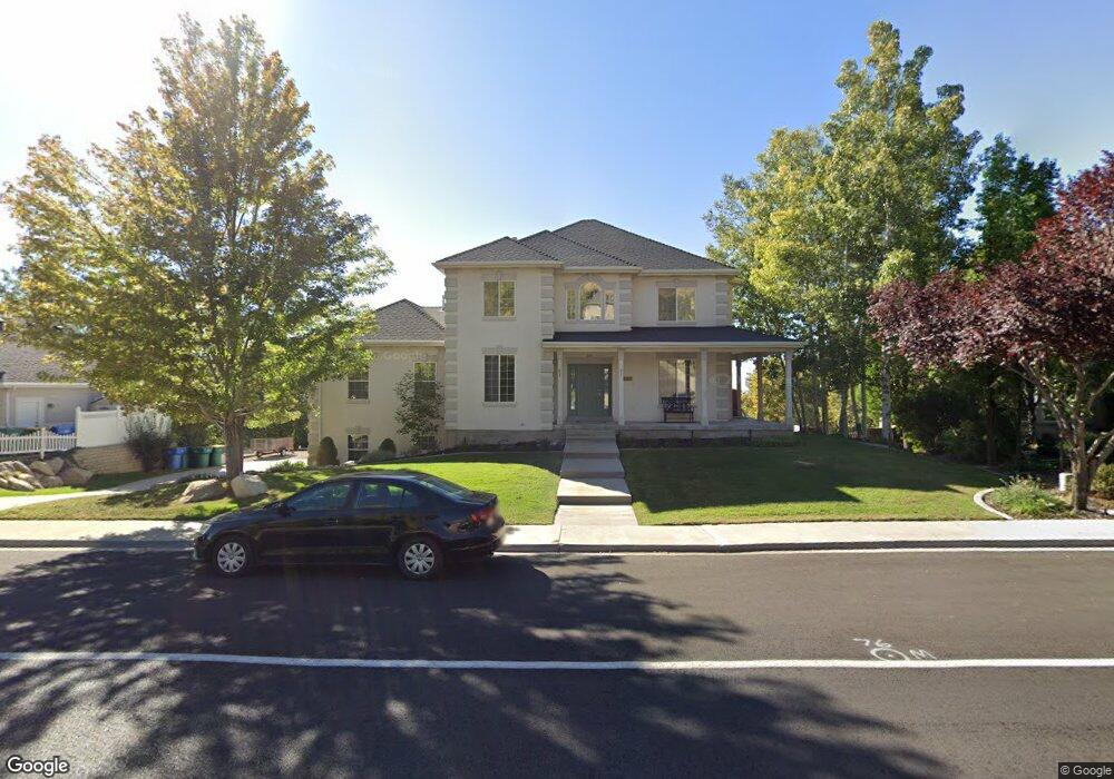
1807 Skyline Dr Orem, UT 84097
Northridge NeighborhoodEstimated Value: $875,452 - $1,035,000
6
Beds
4
Baths
4,326
Sq Ft
$212/Sq Ft
Est. Value
About This Home
This home is located at 1807 Skyline Dr, Orem, UT 84097 and is currently estimated at $919,113, approximately $212 per square foot. 1807 Skyline Dr is a home located in Utah County with nearby schools including Orchard Elementary School, Oak Canyon Junior High School, and Timpanogos High School.
Ownership History
Date
Name
Owned For
Owner Type
Purchase Details
Closed on
Oct 3, 2022
Sold by
Shaw Larry
Bought by
Schaerr Gene Clayton and Schaerr Martha
Current Estimated Value
Home Financials for this Owner
Home Financials are based on the most recent Mortgage that was taken out on this home.
Original Mortgage
$605,500
Outstanding Balance
$576,962
Interest Rate
4.75%
Mortgage Type
New Conventional
Estimated Equity
$342,151
Purchase Details
Closed on
Oct 9, 2019
Sold by
Wright Korey
Bought by
Shaw Larry and Shaw Susan
Home Financials for this Owner
Home Financials are based on the most recent Mortgage that was taken out on this home.
Original Mortgage
$560,000
Interest Rate
3.5%
Mortgage Type
Unknown
Purchase Details
Closed on
Jul 9, 2019
Sold by
Fannie Mae
Bought by
Wright Korey
Purchase Details
Closed on
Jan 16, 2019
Sold by
Shaw Larry and Shaw Susan
Bought by
Federal National Mortgage Association
Purchase Details
Closed on
Jul 8, 2008
Sold by
Allen Joanne M
Bought by
Allen Joanne M and Allen Jeffrey Loren
Purchase Details
Closed on
May 2, 2007
Sold by
Allen Joanne M and Bennett Julianne Allen
Bought by
Allen Scott
Home Financials for this Owner
Home Financials are based on the most recent Mortgage that was taken out on this home.
Original Mortgage
$234,600
Interest Rate
6.15%
Mortgage Type
Purchase Money Mortgage
Purchase Details
Closed on
Dec 8, 2005
Sold by
Allen Joanne M
Bought by
Allen Joanne M and Bennett Julianne Allen
Purchase Details
Closed on
Sep 7, 2005
Sold by
Foust Joanne M
Bought by
Allen Joanne M
Purchase Details
Closed on
May 23, 2002
Sold by
Foust Joanne
Bought by
Foust Joanne M
Home Financials for this Owner
Home Financials are based on the most recent Mortgage that was taken out on this home.
Original Mortgage
$189,000
Interest Rate
6.89%
Purchase Details
Closed on
May 3, 2001
Sold by
L & T Construction Inc
Bought by
Foust Joanne
Create a Home Valuation Report for This Property
The Home Valuation Report is an in-depth analysis detailing your home's value as well as a comparison with similar homes in the area
Home Values in the Area
Average Home Value in this Area
Purchase History
| Date | Buyer | Sale Price | Title Company |
|---|---|---|---|
| Schaerr Gene Clayton | -- | First American Title | |
| Shaw Larry | -- | Juab Title & Abstract Co | |
| Wright Korey | -- | Cottonwood Ttl Ins Agcy Inc | |
| Federal National Mortgage Association | $414,727 | Etitle Insurance Agency | |
| Allen Joanne M | -- | None Available | |
| Allen Joanne M | -- | None Available | |
| Allen Scott | -- | Executive Title | |
| Allen Joanne M | -- | Select Title Insurance Agenc | |
| Allen Joanne M | -- | Signature Title Insurance Ag | |
| Allen Joanne M | -- | Signature Title Insurance A | |
| Foust Joanne M | -- | First American Title Co | |
| Foust Joanne | -- | -- |
Source: Public Records
Mortgage History
| Date | Status | Borrower | Loan Amount |
|---|---|---|---|
| Open | Schaerr Gene Clayton | $605,500 | |
| Previous Owner | Shaw Larry | $560,000 | |
| Previous Owner | Allen Scott | $234,600 | |
| Previous Owner | Foust Joanne M | $189,000 |
Source: Public Records
Tax History
| Year | Tax Paid | Tax Assessment Tax Assessment Total Assessment is a certain percentage of the fair market value that is determined by local assessors to be the total taxable value of land and additions on the property. | Land | Improvement |
|---|---|---|---|---|
| 2025 | $3,358 | $461,945 | -- | -- |
| 2024 | $3,358 | $410,575 | $0 | $0 |
| 2023 | $3,121 | $410,190 | $0 | $0 |
| 2022 | $3,519 | $448,085 | $0 | $0 |
| 2021 | $3,209 | $618,800 | $189,100 | $429,700 |
| 2020 | $3,026 | $573,600 | $164,400 | $409,200 |
| 2019 | $2,581 | $508,700 | $152,900 | $355,800 |
| 2018 | $2,527 | $475,900 | $152,900 | $323,000 |
| 2017 | $2,532 | $255,420 | $0 | $0 |
| 2016 | $2,737 | $254,595 | $0 | $0 |
| 2015 | $2,631 | $231,440 | $0 | $0 |
| 2014 | $2,351 | $205,865 | $0 | $0 |
Source: Public Records
Map
Nearby Homes
- 695 E 1870 N
- 1643 N Mountain Oaks Dr
- 540 E Quail Rd
- 110 S 1320 E
- 713 E 1500 St N Unit 19
- 442 E 1730 N
- 723 E 1450 N Unit 25
- 1366 N 750 E
- 1356 N 750 E Unit 11
- 713 E 1450 N Unit 23
- 733 E 1450 N Unit 5
- 1324 N 750 E Unit 3
- 1480 N 430 E
- 710 E 1280 N
- 558 E 1265 N
- 363 E 1395 N Unit 22
- 1636 N 160 E
- 1638 N 160 E
- 98 S 1025 E
- 1371 N 330 E Unit 8
- 1807 Skyline Dr
- 1823 Skyline Dr
- 1799 Skyline Dr
- 1810 Sunrise Dr
- 799 Sunrise Dr
- 856 E 1810 N
- 859 E 1810 N
- 1824 Skyline Dr
- 1824 Skyline Dr Unit 8
- 1837 Skyline Dr
- 1796 Sunrise Dr
- 1775 Skyline Dr
- 1775 Skyline Dr
- 1775 Skyline Dr
- 1788 Skyline Dr
- 1788 Skyline Dr
- 1836 Skyline Dr
- 796 E 1870 N
- 808 E 1870 N
- 787 Sunrise Dr
Your Personal Tour Guide
Ask me questions while you tour the home.