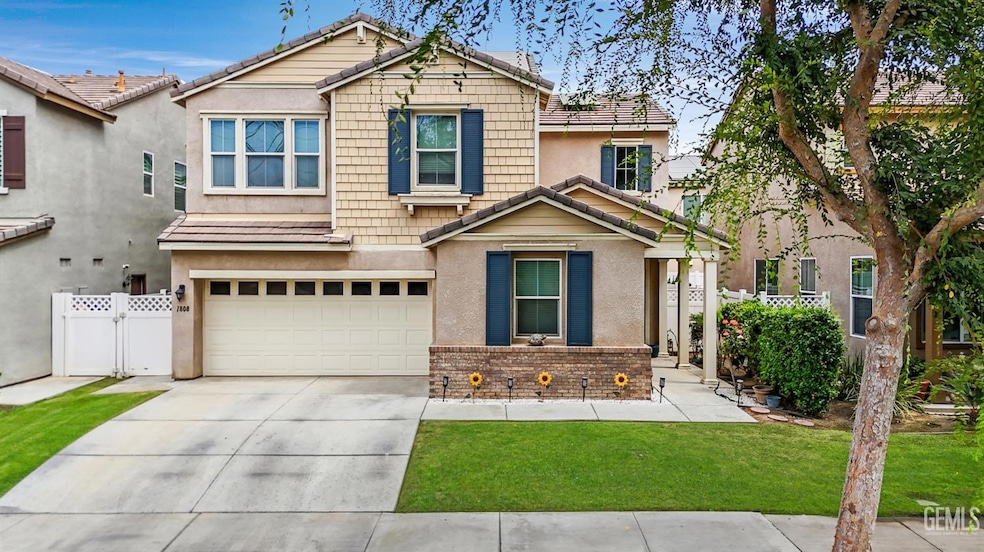
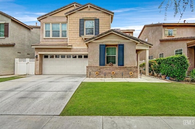
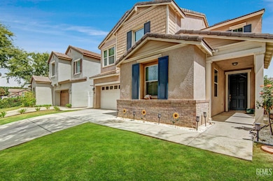
1808 Delacorte Dr Bakersfield, CA 93311
Haggin Oaks NeighborhoodEstimated payment $2,769/month
Highlights
- Gated Community
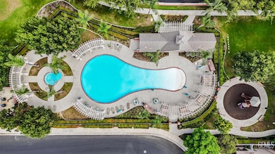
- Community Pool
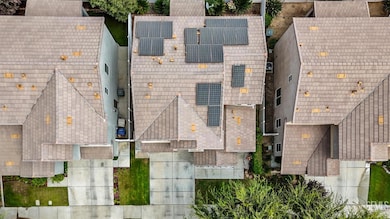
- Solar owned by a third party
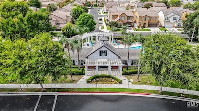
- Clubhouse
- Soaking Tub
- Central Heating and Cooling System
About This Home
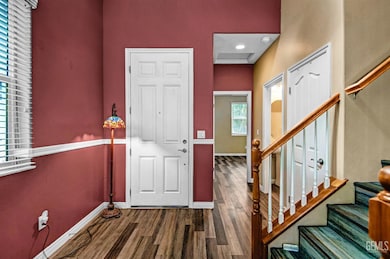
Welcome to this beautiful two story home in the desirable and gated University Park community with an effecient solar system and a new A/C unit installed in June 2025! Step inside to a spacious living area and a stylish kitchen featuring sleek quartz counters, matching backsplash, abundant cabinetry, and a breakfast bar island perfect for casual dining. The primary suite offers a retreat of its own with a large walk-in closet, soaking tub, and separate shower. Outside, enjoy the covered patio for gatherings or use the raised garden beds for your green thumb projects. Residents benefit from access to the clubhouse, pool, park, and BBQ areas, plus neighborhood events that make the community feel alive year-round. Ideally located near the Market Place, CSUB, shopping, dining, and recreation, this southwest Bakersfield home combines comfort, convenience, and charm. Don't wait, schedule your private showing today!
Home Details
Home Type
- Single Family
Year Built
- Built in 2010
Lot Details
- 3,484 Sq Ft Lot
- Zoning described as Rooming House
HOA Fees
- $170 Monthly HOA Fees
Parking
- 2 Car Garage
Interior Spaces
- 1,927 Sq Ft Home
- 2-Story Property
Bedrooms and Bathrooms
- 4 Bedrooms
- 3 Bathrooms
- Soaking Tub
Schools
- Mcauliffe Elementary School
- Tevis Middle School
- Bakersfield High School
Additional Features
- Solar owned by a third party
- Central Heating and Cooling System
Listing and Financial Details
- Assessor Parcel Number 38938811
Community Details
Overview
- University Park Association
Recreation
- Community Pool
Additional Features
- Clubhouse
- Gated Community
Map
Home Values in the Area
Average Home Value in this Area
Tax History
| Year | Tax Paid | Tax Assessment Tax Assessment Total Assessment is a certain percentage of the fair market value that is determined by local assessors to be the total taxable value of land and additions on the property. | Land | Improvement |
|---|---|---|---|---|
| 2025 | $4,746 | $286,366 | $62,796 | $223,570 |
| 2024 | $4,334 | $280,752 | $61,565 | $219,187 |
| 2023 | $4,334 | $275,248 | $60,358 | $214,890 |
| 2022 | $4,296 | $269,852 | $59,175 | $210,677 |
| 2021 | $4,169 | $264,562 | $58,015 | $206,547 |
| 2020 | $4,174 | $261,851 | $57,421 | $204,430 |
| 2019 | $4,123 | $261,851 | $57,421 | $204,430 |
| 2018 | $3,956 | $251,686 | $55,193 | $196,493 |
| 2017 | $3,903 | $246,752 | $54,111 | $192,641 |
| 2016 | $3,677 | $241,914 | $53,050 | $188,864 |
| 2015 | $3,656 | $238,282 | $52,254 | $186,028 |
| 2014 | $3,624 | $233,615 | $51,231 | $182,384 |
Property History
| Date | Event | Price | List to Sale | Price per Sq Ft |
|---|---|---|---|---|
| 02/17/2026 02/17/26 | Price Changed | $409,000 | -2.6% | $212 / Sq Ft |
| 10/21/2025 10/21/25 | Price Changed | $419,999 | -2.3% | $218 / Sq Ft |
| 09/03/2025 09/03/25 | For Sale | $430,000 | -- | $223 / Sq Ft |
Purchase History
| Date | Type | Sale Price | Title Company |
|---|---|---|---|
| Grant Deed | -- | Ticor Title Company Of Ca |
Mortgage History
| Date | Status | Loan Amount | Loan Type |
|---|---|---|---|
| Open | $222,156 | FHA |
Source: Bakersfield Association of REALTORS® / GEMLS
MLS Number: 202509783
APN: 389-388-11-00-3
Disclaimer: Certain information contained herein is derived from information provided by parties other than Homes.com. All information provided is deemed reliable, but is not guaranteed to be accurate and should be independently verified.
![]() Information is deemed reliable but not guaranteed.
Information is deemed reliable but not guaranteed.
Copyright Golden Empire MLS, Inc. 2026.
- 8302 Allyn Bacon Ave
- 8315 Bantam St
- 1821 Delacorte Dr
- 8214 Prentice Hall Dr
- 1714 Holt Rinehart Ave
- 1927 Holt Rinehart Ave
- 7701 Shetland Dr
- 1912 Glenbrea Ct
- 7705 Calle Cerca
- 1113 Calle Extrano
- 1000 Halterio Ct
- 7301 Calle Sagrada
- 1808 El Portal Dr
- 2713 Pecangrove Dr
- 7305 Calle Los Batiquitos
- 2200 Gambel Oak Way
- 2909 Woodglen Dr
- 608 Berwick St Unit 1
- 8201 Norfolk Ct
- 600 Berwick St
- 8200 N Laurelglen Blvd
- 8101 Camino Media
- 8109 Fawn St
- 7107 Ming Ave
- 7913 S Laurelglen Blvd
- 7913 S Laurelglen Blvd
- 9704 Portland Rose Ave Unit 9704 Portland Rose Ave
- 2601 Ashe Rd
- 1304 La Puente Dr
- 802 Windsor Park Dr
- 6301 Ming Ave
- 7800 Westfield Rd
- 5909 Nogal Ave Unit Second Floor C
- 5801 Ming Ave
- 3801 Ashe Rd
- 6500 White Ln
- 5700 Ming Ave
- 5601 Ming Ave
- 9328 Carvalho Ct
- 8400 White Rock Dr

Ask me questions while you tour the home.