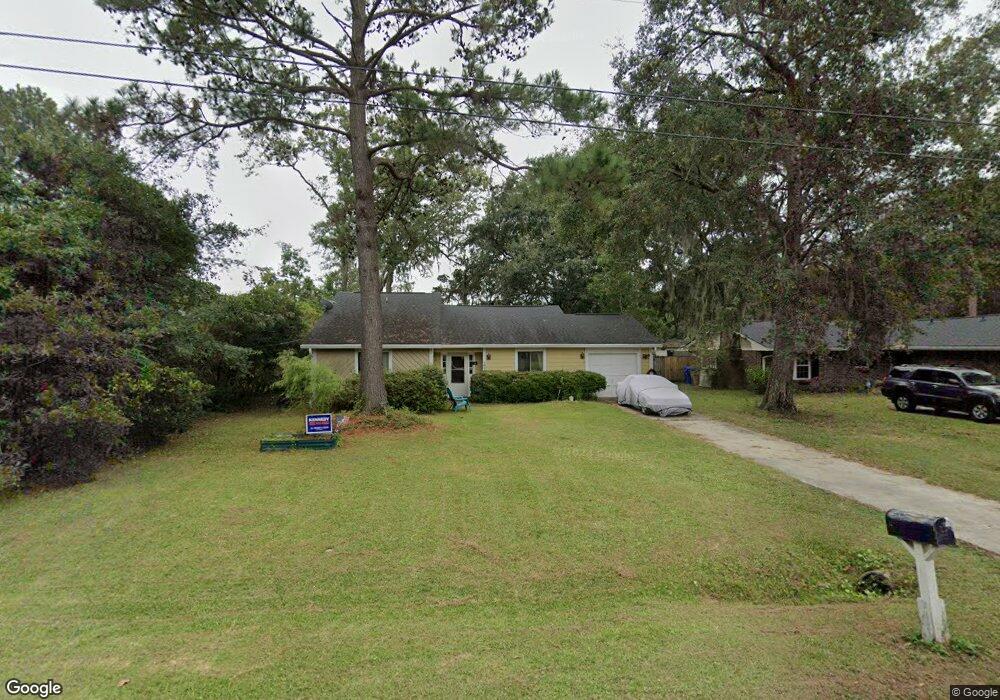
1809 Aylsford Ct Charleston, SC 29412
James Island NeighborhoodEstimated Value: $490,516 - $600,000
3
Beds
2
Baths
1,381
Sq Ft
$403/Sq Ft
Est. Value
About This Home
This home is located at 1809 Aylsford Ct, Charleston, SC 29412 and is currently estimated at $556,379, approximately $402 per square foot. 1809 Aylsford Ct is a home located in Charleston County with nearby schools including James Island Elementary School, Camp Road Middle, and Septima P Clark Corporate Academy.
Ownership History
Date
Name
Owned For
Owner Type
Purchase Details
Closed on
Dec 4, 2024
Sold by
Smith Deena F and Deena Fawn Llc
Bought by
Smith Living Trust and Smith
Current Estimated Value
Purchase Details
Closed on
Aug 20, 2009
Sold by
Deena Fawn Llc
Bought by
Smith Deena F
Purchase Details
Closed on
Mar 12, 2007
Sold by
Smith Deena F
Bought by
Deena Fawn Llc
Purchase Details
Closed on
Oct 27, 2006
Sold by
Zehfuss William E
Bought by
Smith Deena F
Purchase Details
Closed on
Feb 26, 2003
Sold by
Zhang Xuan and Dong Fuxing
Bought by
Zehfuss William E
Purchase Details
Closed on
Nov 23, 1999
Sold by
Russ Pye Inc
Bought by
Zhang Xuan and Dong Fuxing
Create a Home Valuation Report for This Property
The Home Valuation Report is an in-depth analysis detailing your home's value as well as a comparison with similar homes in the area
Home Values in the Area
Average Home Value in this Area
Purchase History
| Date | Buyer | Sale Price | Title Company |
|---|---|---|---|
| Smith Living Trust | -- | None Listed On Document | |
| Smith Deena F | -- | -- | |
| Deena Fawn Llc | -- | None Available | |
| Smith Deena F | $215,000 | None Available | |
| Zehfuss William E | $142,500 | -- | |
| Zhang Xuan | $129,900 | -- |
Source: Public Records
Tax History Compared to Growth
Tax History
| Year | Tax Paid | Tax Assessment Tax Assessment Total Assessment is a certain percentage of the fair market value that is determined by local assessors to be the total taxable value of land and additions on the property. | Land | Improvement |
|---|---|---|---|---|
| 2024 | $1,206 | $8,560 | $0 | $0 |
| 2023 | $1,206 | $8,560 | $0 | $0 |
| 2022 | $1,102 | $8,560 | $0 | $0 |
| 2021 | $1,153 | $8,560 | $0 | $0 |
| 2020 | $1,194 | $8,560 | $0 | $0 |
| 2019 | $1,067 | $7,440 | $0 | $0 |
| 2017 | $1,032 | $7,440 | $0 | $0 |
| 2016 | $991 | $7,440 | $0 | $0 |
| 2015 | $1,023 | $7,440 | $0 | $0 |
| 2014 | $899 | $0 | $0 | $0 |
| 2011 | -- | $0 | $0 | $0 |
Source: Public Records
Map
Nearby Homes
- 1047 Bradford Ave
- 1815 Walsingham Way
- 1056 Yorktown Dr
- 1039 Yorktown Dr
- 1827 S Mayflower Dr
- 1814 S Mayflower Dr
- 0 Turkey Pen Rd Unit 16023532
- 1152 Bradford Ave
- 1030 Pauline Ave
- 1153 Pauline Ave
- 1182 Folly Rd Unit A,B,C,D
- 1137 Rivercrest Dr
- 1206 Folly Rd
- 1662 Dexter Ln
- 1014 Arborwood Dr
- 1135 Bellwood Rd
- 1570 Blaze Ln
- 21 Rivers Point Row Unit 11 C
- 21 Rivers Point Row Unit 3C
- 1 S Anderson Ave
- 1813 Aylsford Ct
- 1805 Aylsford Ct
- 1817 Aylsford Ct
- 1808 Aylsford Ct
- 1803 Aylsford Ct
- 1812 Aylsford Ct
- 1802 Aylsford Ct
- 1821 Aylsford Ct
- 1804 Aylsford Ct
- 1816 Aylsford Ct
- 1820 Aylsford Ct
- 1048 Yorktown Dr
- 1807 Walsingham Way
- 1040 Yorktown Dr
- 1803 Walsingham Way
- 1819 Walsingham Way
- 1064 Yorktown Dr
- 1823 Walsingham Way
- 1047 Yorktown Dr
- 1043 Yorktown Dr