
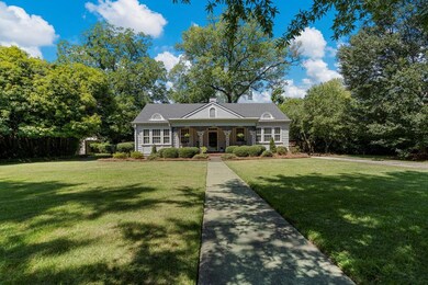
1809 Carter Ave Columbus, GA 31906
Wyntonn Grove NeighborhoodEstimated payment $2,369/month
Highlights
- Golf Course Community
- Living Room with Fireplace
- No HOA
- Deck
- Wood Flooring
- Tennis Courts
About This Home
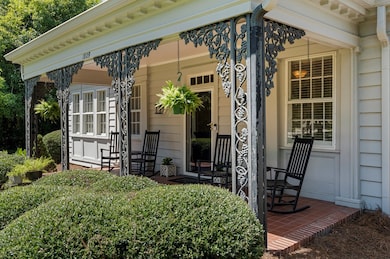
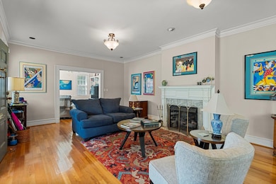
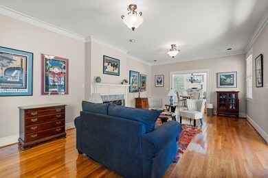
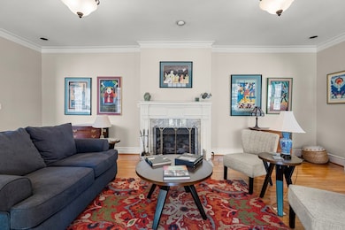
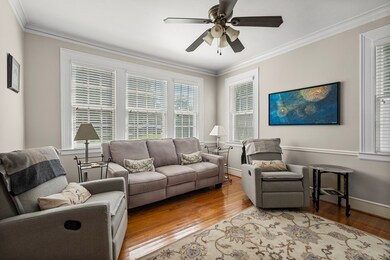
Welcome to this wonderful 1928 residence nestled in the heart of Midtown in one of it's most coveted neighborhoods! Enter through the inviting wrought iron adorned front porch and discover a home that perfectly blends historic character with functionality. This unique & charming property graces the tree-lined sidewalks of highly sought-after Carter Avenue, on one of the city's most desirable locations. Interior Features : 3 spacious bedrooms and 3 full bathrooms, gleaming hardwood floors throughout, large custom windows flooding each room with natural light, soaring high ceilings and exquisite millwork, and two fireplaces with marble surrounds and custom mantles. The main floor offers effortless entertaining with a central living room, flanked on each side by a comfortable den and formal dining room, flowing into a spacious kitchen perfect for culinary adventures. The oversized primary suite and two guest Bedrooms complete the main floor. The terrace level of this home boasts a bonus room brimming with possibilities – envision it as a teen retreat, recreation room, sophisticated man cave, or additional family space. The lower level also features a convenient bar area and dual access points to the backyard and deck. The established landscaping creates a private back yard oasis, anchored by a magnificent old oak tree that adds both beauty and shade. A detached garage provides practical storage and parking solutions, while the deck offers the perfect outdoor entertaining space. This remarkable property presents an exceptional opportunity for the discerning buyer to infuse their personal style and creativity, making this historic gem into a truly one-of-a-kind sanctuary. Don't miss this rare chance to own a unique piece of Midtown history on prestigious Carter Avenue! Call today for your private tour.
Listing Agent
Bickerstaff Parham, LLC Brokerage Phone: 7066531400 License #325535 Listed on: 11/03/2025

Home Details
Home Type
- Single Family
Est. Annual Taxes
- $3,180
Year Built
- Built in 1928
Lot Details
- 0.34 Acre Lot
- Fenced
- Landscaped
- Level Lot
- Back Yard
Parking
- 2 Car Detached Garage
- Driveway
- Open Parking
Home Design
- Bungalow
- Frame Construction
Interior Spaces
- 3,100 Sq Ft Home
- 1-Story Property
- Wet Bar
- Living Room with Fireplace
- 2 Fireplaces
- Wood Flooring
- Finished Basement
- Laundry in Basement
- Laundry Room
Kitchen
- Electric Range
- Dishwasher
- Disposal
Bedrooms and Bathrooms
- 3 Main Level Bedrooms
- Walk-In Closet
- 3 Full Bathrooms
Outdoor Features
- Deck
- Outbuilding
Utilities
- Cooling Available
- Heating System Uses Natural Gas
- Cable TV Available
Listing and Financial Details
- Assessor Parcel Number 185020013
Community Details
Overview
- No Home Owners Association
- Woodcrest Subdivision
Recreation
- Golf Course Community
- Tennis Courts
- Park
Map
Home Values in the Area
Average Home Value in this Area
Tax History
| Year | Tax Paid | Tax Assessment Tax Assessment Total Assessment is a certain percentage of the fair market value that is determined by local assessors to be the total taxable value of land and additions on the property. | Land | Improvement |
|---|---|---|---|---|
| 2025 | $3,180 | $114,340 | $22,472 | $91,868 |
| 2024 | $318 | $114,340 | $22,472 | $91,868 |
| 2023 | $2,504 | $114,340 | $22,472 | $91,868 |
| 2022 | $3,315 | $95,272 | $22,472 | $72,800 |
| 2021 | $3,308 | $94,412 | $22,472 | $71,940 |
| 2020 | $4,591 | $94,412 | $22,472 | $71,940 |
| 2019 | $4,607 | $94,412 | $22,472 | $71,940 |
| 2018 | $4,607 | $94,412 | $22,472 | $71,940 |
| 2017 | $4,624 | $94,412 | $22,472 | $71,940 |
| 2016 | $4,642 | $125,800 | $18,200 | $107,600 |
| 2015 | $4,648 | $125,800 | $18,200 | $107,600 |
| 2014 | $4,654 | $125,800 | $18,200 | $107,600 |
| 2013 | -- | $125,800 | $18,200 | $107,600 |
Property History
| Date | Event | Price | List to Sale | Price per Sq Ft | Prior Sale |
|---|---|---|---|---|---|
| 11/13/2025 11/13/25 | Pending | -- | -- | -- | |
| 11/03/2025 11/03/25 | For Sale | $399,900 | +35.6% | $129 / Sq Ft | |
| 12/18/2020 12/18/20 | Sold | $295,000 | -- | $93 / Sq Ft | View Prior Sale |
| 10/26/2020 10/26/20 | Pending | -- | -- | -- |
Purchase History
| Date | Type | Sale Price | Title Company |
|---|---|---|---|
| Warranty Deed | $295,000 | -- |
Mortgage History
| Date | Status | Loan Amount | Loan Type |
|---|---|---|---|
| Open | $236,000 | New Conventional |
Source: Columbus Board of REALTORS® (GA)
MLS Number: 224254
APN: 185-020-013
Disclaimer: Certain information contained herein is derived from information provided by parties other than Homes.com. All information provided is deemed reliable, but is not guaranteed to be accurate and should be independently verified.
![]() IDX information is provided exclusively for personal, non-commercial use, and may not be used for any purpose other than to identify prospective properties consumers may be interested in purchasing. Information is deemed reliable but not guaranteed.
IDX information is provided exclusively for personal, non-commercial use, and may not be used for any purpose other than to identify prospective properties consumers may be interested in purchasing. Information is deemed reliable but not guaranteed.
- 1717 Stark Ave
- 1806 Stark Ave
- 1706 Stark Ave
- 1700 Stark Ave
- 2227 15th St
- 2104 Cherokee Ave
- 2016 Poplar Dr
- 2230 Cherokee Ave Unit 10
- 1400 Eberhart Ave
- 2010 Wells Dr
- 2125 13th St Unit 12
- 2133 13th St
- 1319 Hilton Ave
- 1557 18th Ave
- 2533 15th St
- 1917 Dimon St
- 1513 Wells Dr
- 1525 19th St
- 2609 Hilton Ave
- 2220 Country Club Rd