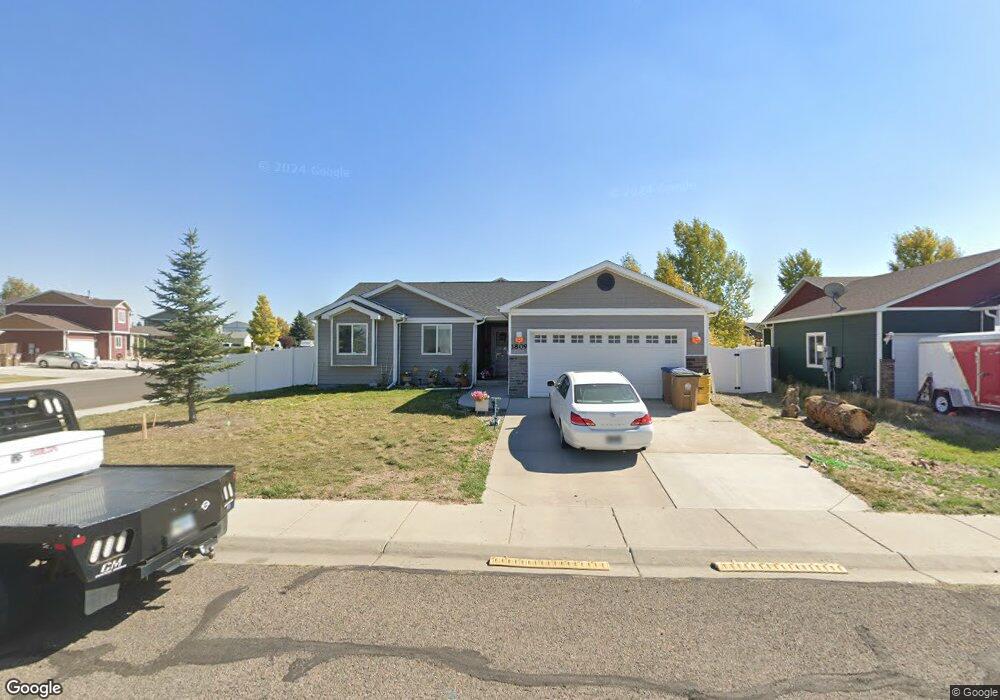
1809 S 13th St Laramie, WY 82070
Estimated Value: $366,000 - $406,000
3
Beds
2
Baths
1,426
Sq Ft
$268/Sq Ft
Est. Value
About This Home
This home is located at 1809 S 13th St, Laramie, WY 82070 and is currently estimated at $382,443, approximately $268 per square foot. 1809 S 13th St is a home with nearby schools including Spring Creek Elementary School, Laramie Middle School, and Laramie High School.
Ownership History
Date
Name
Owned For
Owner Type
Purchase Details
Closed on
Apr 13, 2013
Sold by
Malmstrom Craig A and Malmstrom Page A
Bought by
Collins George E and Collins Betty E
Current Estimated Value
Home Financials for this Owner
Home Financials are based on the most recent Mortgage that was taken out on this home.
Original Mortgage
$167,920
Outstanding Balance
$118,957
Interest Rate
3.55%
Mortgage Type
New Conventional
Estimated Equity
$263,486
Purchase Details
Closed on
Apr 4, 2012
Sold by
Gateway Construction Llc Co
Bought by
Malmstrom Craig A and Malmstrom Page A
Home Financials for this Owner
Home Financials are based on the most recent Mortgage that was taken out on this home.
Original Mortgage
$182,150
Interest Rate
3.97%
Mortgage Type
New Conventional
Create a Home Valuation Report for This Property
The Home Valuation Report is an in-depth analysis detailing your home's value as well as a comparison with similar homes in the area
Home Values in the Area
Average Home Value in this Area
Purchase History
| Date | Buyer | Sale Price | Title Company |
|---|---|---|---|
| Collins George E | -- | None Available | |
| Malmstrom Craig A | -- | None Available |
Source: Public Records
Mortgage History
| Date | Status | Borrower | Loan Amount |
|---|---|---|---|
| Open | Collins George E | $167,920 | |
| Previous Owner | Malmstrom Craig A | $182,150 |
Source: Public Records
Tax History Compared to Growth
Tax History
| Year | Tax Paid | Tax Assessment Tax Assessment Total Assessment is a certain percentage of the fair market value that is determined by local assessors to be the total taxable value of land and additions on the property. | Land | Improvement |
|---|---|---|---|---|
| 2025 | $2,477 | $26,462 | $3,846 | $22,616 |
| 2024 | $2,477 | $33,926 | $4,931 | $28,995 |
| 2023 | $2,461 | $33,708 | $4,931 | $28,777 |
| 2022 | $2,027 | $27,762 | $4,931 | $22,831 |
| 2021 | $1,688 | $25,188 | $4,051 | $21,137 |
| 2020 | $1,777 | $24,348 | $4,051 | $20,297 |
| 2019 | $1,720 | $23,565 | $4,051 | $19,514 |
| 2018 | $1,688 | $23,123 | $4,051 | $19,072 |
| 2017 | $1,564 | $21,431 | $4,051 | $17,380 |
| 2016 | $1,549 | $21,225 | $4,051 | $17,174 |
| 2015 | $1,468 | $20,574 | $4,038 | $16,536 |
| 2014 | $1,468 | $20,103 | $0 | $0 |
Source: Public Records
Map
Nearby Homes
- 1303 Person St
- Lot37Blk2 Boswell Dr
- Lot38Blk2 Boswell Dr
- Lot19Blk 4 Boswell Dr
- Blk7 Lot2 Boswell Dr
- 1534 Palmer Dr Unit 4
- 1027 Boswell Dr
- 1613 Barratt St
- 1425 Fetterman Dr
- 1206 S 11th St
- 29 Star Struck Ln
- 1412 S 17th St Unit A
- 1714 Symons St
- 912 Fetterman Dr
- 903 Sanders Dr
- 1722 Barratt St
- 1727 E Palmer Dr
- 906 S 15th St
- 1121 S 7th St
- 1203 E Park Ave