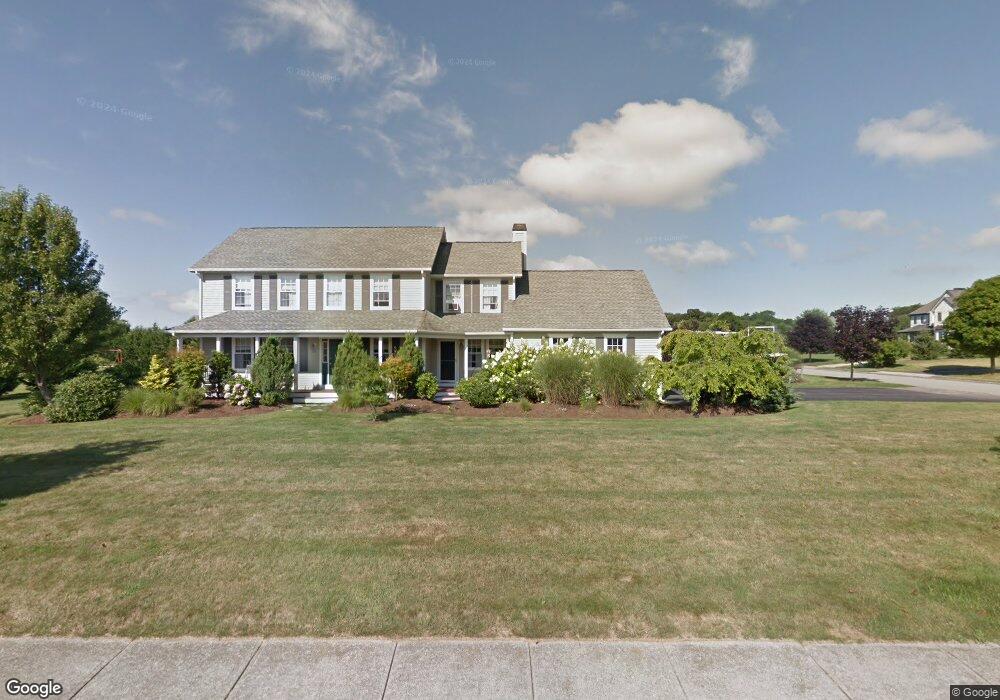
181 Compton View Dr Middletown, RI 02842
Estimated Value: $1,321,000 - $1,780,787
4
Beds
3
Baths
2,710
Sq Ft
$585/Sq Ft
Est. Value
About This Home
This home is located at 181 Compton View Dr, Middletown, RI 02842 and is currently estimated at $1,586,197, approximately $585 per square foot. 181 Compton View Dr is a home located in Newport County with nearby schools including Middletown High School, St Michael's Country Day School, and St George's School.
Ownership History
Date
Name
Owned For
Owner Type
Purchase Details
Closed on
Feb 29, 2008
Sold by
Benkhart Carlyne
Bought by
Forster Christopher and Forster Meredith
Current Estimated Value
Purchase Details
Closed on
Oct 25, 2002
Sold by
Locks John T
Bought by
Benkhart Carlyne
Purchase Details
Closed on
May 15, 1998
Sold by
Ocean Ridge Dev Llc
Bought by
Locks John F
Create a Home Valuation Report for This Property
The Home Valuation Report is an in-depth analysis detailing your home's value as well as a comparison with similar homes in the area
Home Values in the Area
Average Home Value in this Area
Purchase History
| Date | Buyer | Sale Price | Title Company |
|---|---|---|---|
| Forster Christopher | $650,000 | -- | |
| Benkhart Carlyne | $420,000 | -- | |
| Locks John F | $255,000 | -- |
Source: Public Records
Mortgage History
| Date | Status | Borrower | Loan Amount |
|---|---|---|---|
| Open | Locks John F | $30,000 | |
| Open | Locks John F | $505,642 |
Source: Public Records
Tax History
| Year | Tax Paid | Tax Assessment Tax Assessment Total Assessment is a certain percentage of the fair market value that is determined by local assessors to be the total taxable value of land and additions on the property. | Land | Improvement |
|---|---|---|---|---|
| 2025 | $12,995 | $1,102,200 | $405,800 | $696,400 |
| 2024 | $12,411 | $1,102,200 | $405,800 | $696,400 |
| 2023 | $11,048 | $877,500 | $287,600 | $589,900 |
| 2022 | $10,548 | $877,500 | $287,600 | $589,900 |
| 2021 | $7,342 | $610,800 | $287,600 | $323,200 |
| 2020 | $7,141 | $519,000 | $235,100 | $283,900 |
| 2018 | $7,136 | $519,000 | $235,100 | $283,900 |
| 2016 | $8,088 | $524,500 | $239,100 | $285,400 |
| 2015 | $7,888 | $524,500 | $239,100 | $285,400 |
| 2014 | $7,987 | $497,000 | $218,100 | $278,900 |
| 2013 | $7,808 | $497,000 | $218,100 | $278,900 |
Source: Public Records
Map
Nearby Homes
- 476 Green End Ave
- 310 Corey Ln
- 265 Prospect Ave
- 10 Oceanview Dr
- 223 Corey Ln
- 81 Beagle Dr
- 206 Reservoir Rd
- 23 Indian Hill Cir
- 16 Ward Ave
- 55 John Clarke Rd Unit 8
- 55 John Clarke Rd Unit 3
- 118 Wolcott Ave
- 141 Gray Craig Rd
- 181 Center Ave
- 10 Smithfield Dr
- 7 Restmere Terrace
- 1 Ichabod Ln
- 14 Kay Blvd
- 74 Valley Rd
- 0 Allston Ave
- 11 Lighthouse Dr
- 0 Compton View Dr
- 195 Compton View Dr
- 40 Lighthouse View Dr
- 40 Lighthouse Dr
- 11 Lighthouse View Dr
- 170 Compton View Dr
- 190 Compton View Dr
- 25 Lighthouse View Dr
- 80 Lighthouse View Dr
- 80 Lighthouse Dr
- 200 Compton View Dr
- 221 Compton View Dr
- 140 Compton View Dr
- 41 Lighthouse Dr
- 41 Lighthouse View Dr
- 145 Compton View Dr
- 220 Compton View Dr
- 51 Lighthouse Dr
- 51 Lighthouse View Dr
Your Personal Tour Guide
Ask me questions while you tour the home.