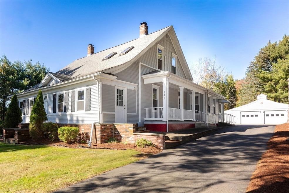


181 Paine Rd North Attleboro, MA 02760
North Attleboro NeighborhoodEstimated payment $4,368/month
Highlights
- Community Stables
- Landscaped Professionally
- Wood Flooring
- 3.97 Acre Lot
- Wooded Lot
- Main Floor Primary Bedroom
About This Home
Welcome Home! Discover this charming farmhouse nestled on 4 acres of private, wooded land perfect for those who love peace, nature, and outdoor entertaining. Step inside to an inviting enclosed, heated porch, leading to a cozy front room ideal for guests or a home office. The kitchen and dining area are separated by a breakfast bar, creating a warm and functional layout. All bedrooms are located on the main floor, with a spacious 2-bedroom, 1-bath In-Law Suite upstairs, great for extended family or guests. The full basement offers ample storage plus a heated finished room perfect for a gym, studio, or hobby space. For the craftsman or hobbyist, enjoy a 3-car garage/workshop with wood stove, an additional recreation room, and extra storage areas throughout. Located in desirable North Attleboro, this home offers country charm with convenient access to shopping, restaurants, and major highways.

Home Details
Home Type
- Single Family
Est. Annual Taxes
- $6,347
Year Built
- Built in 1920
Lot Details
- 3.97 Acre Lot
- Landscaped Professionally
- Level Lot
- Wooded Lot
Parking
- 3 Car Detached Garage
- Parking Storage or Cabinetry
- Heated Garage
- Workshop in Garage
- Side Facing Garage
- Garage Door Opener
- Driveway
- Open Parking
- Off-Street Parking
Home Design
- Farmhouse Style Home
- Frame Construction
- Shingle Roof
- Concrete Perimeter Foundation
Interior Spaces
- 2,601 Sq Ft Home
- 3 Fireplaces
- Combination Dining and Living Room
Kitchen
- Range
- Microwave
- Dishwasher
Flooring
- Wood
- Carpet
- Tile
Bedrooms and Bathrooms
- 4 Bedrooms
- Primary Bedroom on Main
- In-Law or Guest Suite
- 2 Full Bathrooms
Laundry
- Dryer
- Washer
Partially Finished Basement
- Basement Fills Entire Space Under The House
- Laundry in Basement
Outdoor Features
- Enclosed Patio or Porch
- Outdoor Storage
- Rain Gutters
Utilities
- Ductless Heating Or Cooling System
- Whole House Fan
- Window Unit Cooling System
- 1 Cooling Zone
- 3 Heating Zones
- Heating System Uses Natural Gas
- Gas Water Heater
- Private Sewer
- Satellite Dish
Listing and Financial Details
- Assessor Parcel Number M:0026 B:0021 L:0000,2872487
Community Details
Recreation
- Community Stables
Additional Features
- No Home Owners Association
- Shops
Map
Home Values in the Area
Average Home Value in this Area
Tax History
| Year | Tax Paid | Tax Assessment Tax Assessment Total Assessment is a certain percentage of the fair market value that is determined by local assessors to be the total taxable value of land and additions on the property. | Land | Improvement |
|---|---|---|---|---|
| 2025 | $6,347 | $538,300 | $148,500 | $389,800 |
| 2024 | $6,056 | $524,800 | $148,500 | $376,300 |
| 2023 | $5,926 | $463,300 | $148,500 | $314,800 |
| 2022 | $5,898 | $423,400 | $148,500 | $274,900 |
| 2021 | $5,625 | $394,200 | $148,500 | $245,700 |
| 2020 | $4,214 | $388,500 | $148,500 | $240,000 |
| 2019 | $5,213 | $366,100 | $135,400 | $230,700 |
| 2018 | $4,056 | $347,400 | $135,400 | $212,000 |
| 2017 | $3,849 | $328,800 | $135,400 | $193,400 |
| 2016 | $4,122 | $311,800 | $150,200 | $161,600 |
| 2015 | $3,950 | $300,600 | $157,600 | $143,000 |
| 2014 | $3,997 | $301,900 | $145,900 | $156,000 |
Property History
| Date | Event | Price | List to Sale | Price per Sq Ft |
|---|---|---|---|---|
| 11/11/2025 11/11/25 | Pending | -- | -- | -- |
| 11/04/2025 11/04/25 | Price Changed | $729,900 | -2.7% | $281 / Sq Ft |
| 10/14/2025 10/14/25 | For Sale | $749,900 | -- | $288 / Sq Ft |
Purchase History
| Date | Type | Sale Price | Title Company |
|---|---|---|---|
| Quit Claim Deed | -- | -- | |
| Land Court Massachusetts | $370,000 | -- | |
| Land Court Massachusetts | $370,000 | -- | |
| Land Court Massachusetts | $90,000 | -- |
Mortgage History
| Date | Status | Loan Amount | Loan Type |
|---|---|---|---|
| Previous Owner | $250,000 | No Value Available | |
| Previous Owner | $270,000 | Purchase Money Mortgage |
About the Listing Agent
Source: MLS Property Information Network (MLS PIN)
MLS Number: 73443255
APN: NATT-000026-000021
Disclaimer: Certain information contained herein is derived from information provided by parties other than Homes.com. All information provided is deemed reliable, but is not guaranteed to be accurate and should be independently verified.
![]() The property listing data and information, or the Images, set forth herein were provided to MLS Property Information Network, Inc. from third party sources, including sellers, lessors and public records, and were compiled by MLS Property Information Network, Inc. The property listing data and information, and the Images, are for the personal, non-commercial use of consumers having a good faith interest in purchasing or leasing listed properties of the type displayed to them and may not be used for any purpose other than to identify prospective properties which such consumers may have a good faith interest in purchasing or leasing. MLS Property Information Network, Inc. and its subscribers disclaim any and all representations and warranties as to the accuracy of the property listing data and information, or as to the accuracy of any of the Images, set forth herein.
The property listing data and information, or the Images, set forth herein were provided to MLS Property Information Network, Inc. from third party sources, including sellers, lessors and public records, and were compiled by MLS Property Information Network, Inc. The property listing data and information, and the Images, are for the personal, non-commercial use of consumers having a good faith interest in purchasing or leasing listed properties of the type displayed to them and may not be used for any purpose other than to identify prospective properties which such consumers may have a good faith interest in purchasing or leasing. MLS Property Information Network, Inc. and its subscribers disclaim any and all representations and warranties as to the accuracy of the property listing data and information, or as to the accuracy of any of the Images, set forth herein.
- 31 Paine Rd
- 740 Allen Ave
- 44 Montclair Dr
- 637 S Washington St Unit 47
- 164 Bear Hill Rd Unit 24
- 135 Cumberland Ave
- 29 May St
- 0 Mendon Rd
- 154 Bear Hill Rd Unit 405
- 807 Paine Rd
- 94 Abbott Run Valley Rd
- 295 Newport Ave
- 34 Stone Ridge Rd
- 27 Killarney Way
- 15 Standring St
- 47 Reservoir St
- 517 Newport Ave
- 11 Primrose Terrace
- 94 Hines Rd
- 41 Indiana Ave