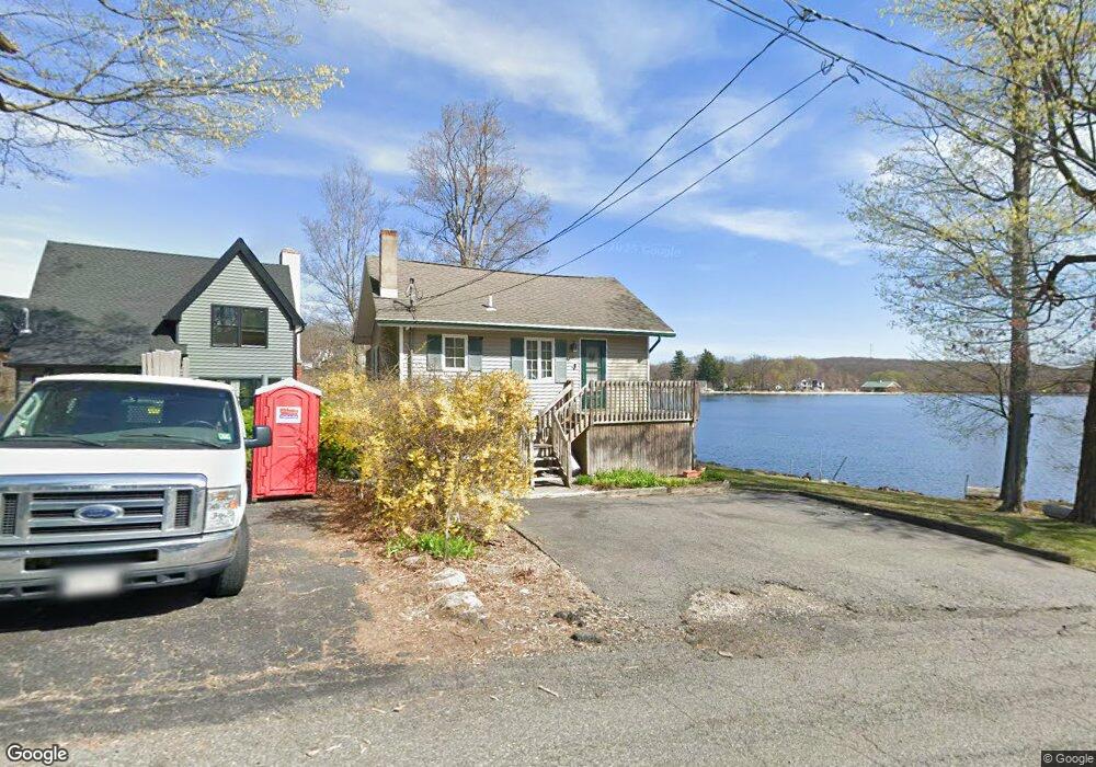
181 Point Breeze Dr Hewitt, NJ 07421
Estimated Value: $332,000 - $593,000
--
Bed
--
Bath
576
Sq Ft
$828/Sq Ft
Est. Value
About This Home
This home is located at 181 Point Breeze Dr, Hewitt, NJ 07421 and is currently estimated at $476,837, approximately $827 per square foot. 181 Point Breeze Dr is a home located in Passaic County with nearby schools including Macopin Middle School and West Milford High School.
Ownership History
Date
Name
Owned For
Owner Type
Purchase Details
Closed on
Dec 21, 2004
Sold by
Samuel Raymond
Bought by
Coyman Robert
Current Estimated Value
Home Financials for this Owner
Home Financials are based on the most recent Mortgage that was taken out on this home.
Original Mortgage
$126,000
Interest Rate
5.77%
Purchase Details
Closed on
Mar 26, 1999
Sold by
Mulligan David J
Bought by
Romaniello Charles and Romaniello Carmen
Create a Home Valuation Report for This Property
The Home Valuation Report is an in-depth analysis detailing your home's value as well as a comparison with similar homes in the area
Home Values in the Area
Average Home Value in this Area
Purchase History
| Date | Buyer | Sale Price | Title Company |
|---|---|---|---|
| Coyman Robert | $140,000 | -- | |
| Romaniello Charles | $155,000 | -- |
Source: Public Records
Mortgage History
| Date | Status | Borrower | Loan Amount |
|---|---|---|---|
| Previous Owner | Coyman Robert | $126,000 |
Source: Public Records
Tax History Compared to Growth
Tax History
| Year | Tax Paid | Tax Assessment Tax Assessment Total Assessment is a certain percentage of the fair market value that is determined by local assessors to be the total taxable value of land and additions on the property. | Land | Improvement |
|---|---|---|---|---|
| 2025 | $9,571 | $236,100 | $162,200 | $73,900 |
| 2024 | $9,621 | $236,100 | $162,200 | $73,900 |
| 2022 | $9,132 | $236,100 | $162,200 | $73,900 |
| 2021 | $8,936 | $236,100 | $162,200 | $73,900 |
| 2020 | $8,842 | $236,100 | $162,200 | $73,900 |
| 2019 | $8,724 | $236,100 | $162,200 | $73,900 |
| 2018 | $8,703 | $236,100 | $162,200 | $73,900 |
| 2017 | $8,743 | $236,100 | $162,200 | $73,900 |
| 2016 | $8,757 | $236,100 | $162,200 | $73,900 |
| 2015 | $8,655 | $236,100 | $162,200 | $73,900 |
| 2014 | $8,445 | $236,100 | $162,200 | $73,900 |
Source: Public Records
Map
Nearby Homes
- 40 Upper Greenwood Rd
- 40 Upper Greenwood Lake Rd
- 230 Point Breeze Dr
- 530 Lake Shore Dr
- 486 Lake Shore Dr
- 10 Paterson Rd
- 0 Kresson Rd
- 3 Riverside Rd
- 10 Emerson Rd
- 1 Norwood Rd
- 12 Riverside Rd
- 116 Point Breeze Dr
- 25 Longhouse Dr
- 54 Race Track Dr
- 6 Dunham Rd
- 00 Fairlawn Dr
- 6 Passaic Dr
- 5 Fanwood Ct
- 4 Rumson Ct
- 179 Point Breeze Dr
- 177 Point Breeze Dr
- 186 Point Breeze Dr
- 173 Point Breeze Dr
- 177 Breeze Dr
- 178 Point Breeze Dr
- 188 Point Breeze Dr
- 189 Point Breeze Dr
- 194 Point Breeze Dr
- 174 Point Breeze Dr
- 191 Point Breeze Dr
- 171 Point Breeze Dr
- 202 Point Breeze Dr
- 170 Point Breeze Dr
- 197 Point Breeze Dr
- 199 Point Breeze Dr
- 195 Point Breeze Dr
- 206 Point Breeze Dr
- 203 Point Breeze Dr
- 168 Point Breeze Dr