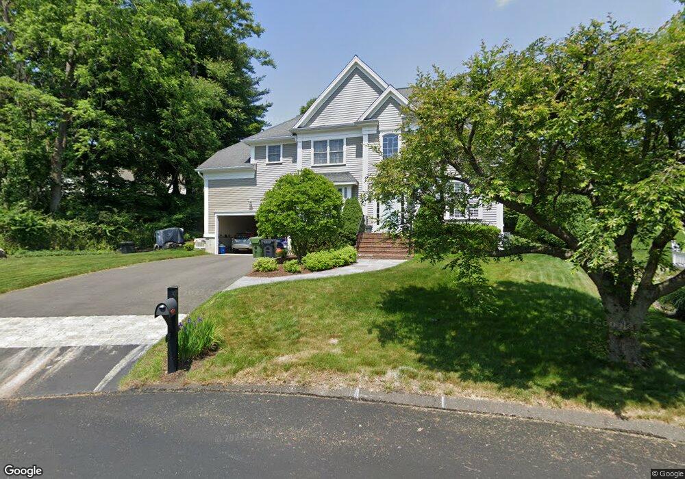
181 Split Rock Rd Southport, CT 06890
Estimated Value: $1,220,000 - $1,617,000
5
Beds
3
Baths
2,816
Sq Ft
$506/Sq Ft
Est. Value
About This Home
This home is located at 181 Split Rock Rd, Southport, CT 06890 and is currently estimated at $1,426,014, approximately $506 per square foot. 181 Split Rock Rd is a home located in Fairfield County with nearby schools including Mill Hill School, Roger Ludlowe Middle School, and Fairfield Ludlowe High School.
Ownership History
Date
Name
Owned For
Owner Type
Purchase Details
Closed on
Apr 6, 2006
Sold by
Maguire Gary and Maguire Leonor
Bought by
Therriault Charles A and Therriault Margaret B
Current Estimated Value
Purchase Details
Closed on
May 25, 2004
Sold by
Split Rock Assoc
Bought by
Maguire Gary and Maguire Leonor
Create a Home Valuation Report for This Property
The Home Valuation Report is an in-depth analysis detailing your home's value as well as a comparison with similar homes in the area
Home Values in the Area
Average Home Value in this Area
Purchase History
| Date | Buyer | Sale Price | Title Company |
|---|---|---|---|
| Therriault Charles A | $875,000 | -- | |
| Therriault Charles A | $875,000 | -- | |
| Maguire Gary | $789,000 | -- | |
| Maguire Gary | $789,000 | -- |
Source: Public Records
Mortgage History
| Date | Status | Borrower | Loan Amount |
|---|---|---|---|
| Open | Maguire Gary | $120,500 | |
| Open | Maguire Gary | $555,000 | |
| Closed | Maguire Gary | $564,000 |
Source: Public Records
Tax History Compared to Growth
Tax History
| Year | Tax Paid | Tax Assessment Tax Assessment Total Assessment is a certain percentage of the fair market value that is determined by local assessors to be the total taxable value of land and additions on the property. | Land | Improvement |
|---|---|---|---|---|
| 2025 | $16,503 | $581,280 | $317,730 | $263,550 |
| 2024 | $16,218 | $581,280 | $317,730 | $263,550 |
| 2023 | $15,991 | $581,280 | $317,730 | $263,550 |
| 2022 | $15,834 | $581,280 | $317,730 | $263,550 |
| 2021 | $15,683 | $581,280 | $317,730 | $263,550 |
| 2020 | $16,805 | $627,270 | $315,630 | $311,640 |
| 2019 | $16,805 | $627,270 | $315,630 | $311,640 |
| 2018 | $16,535 | $627,270 | $315,630 | $311,640 |
| 2017 | $16,196 | $627,270 | $315,630 | $311,640 |
| 2016 | $15,964 | $627,270 | $315,630 | $311,640 |
| 2015 | $16,223 | $654,430 | $315,210 | $339,220 |
| 2014 | $15,968 | $654,430 | $315,210 | $339,220 |
Source: Public Records
Map
Nearby Homes
- 53 Hilltop Dr
- 400 Bronson Rd
- 844 Mill Hill Terrace
- 647 Bronson Rd
- 153 Pease Ave
- 88 Overhill Rd
- 2 Elmwood Dr Unit 2
- 56 Southport Woods Dr
- 27 Bradley St
- 172 Sycamore Ln
- 209 S Pine Creek Rd
- 21 Beaumont St
- 57 Beaumont Place
- 1135 Mill Hill Rd
- 43 Helen St
- 60 Hulls Hwy Unit 60
- 214 Henry St
- 55 Thorpe St
- 52 Glover St
- 74 Westford Dr
- 185 Split Rock Rd
- 111 Split Rock Rd
- 189 Split Rock Rd
- 107 Split Rock Rd
- 73 Rockview Rd
- 193 Split Rock Rd
- 59 Rockview Rd
- 43 Rockview Rd
- 23 Hilltop Dr
- 37 Hilltop Dr
- 85 Split Rock Rd
- 70 Rockview Rd
- 199 Bronson Rd
- 29 Rockview Rd
- 15 Mill Hill Ln
- 52 Rockview Rd
- 51 Mill Hill Ln
- 217 Bronson Rd
- 61 Hilltop Dr
- 38 Rockview Rd