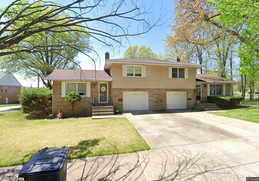
1810 Highview Ave Akron, OH 44301
Firestone Park NeighborhoodEstimated Value: $178,000 - $206,000
4
Beds
2
Baths
1,832
Sq Ft
$104/Sq Ft
Est. Value
About This Home
This home is located at 1810 Highview Ave, Akron, OH 44301 and is currently estimated at $190,325, approximately $103 per square foot. 1810 Highview Ave is a home located in Summit County with nearby schools including Kenmore Garfield Community Learning Center, Eagle Elementary, and Main Preparatory Academy.
Ownership History
Date
Name
Owned For
Owner Type
Purchase Details
Closed on
Sep 30, 2024
Sold by
Deshane Patrick M and Deshane Mary S
Bought by
Equity Trust and Mark Curtis Goehler
Current Estimated Value
Purchase Details
Closed on
Aug 24, 2002
Sold by
Lannan Jean A and Netzley June R
Bought by
Deshane Patrick M and Deshane Mary S
Home Financials for this Owner
Home Financials are based on the most recent Mortgage that was taken out on this home.
Original Mortgage
$82,500
Interest Rate
6.56%
Create a Home Valuation Report for This Property
The Home Valuation Report is an in-depth analysis detailing your home's value as well as a comparison with similar homes in the area
Home Values in the Area
Average Home Value in this Area
Purchase History
| Date | Buyer | Sale Price | Title Company |
|---|---|---|---|
| Equity Trust | $155,000 | Minnesota Title Agency | |
| Deshane Patrick M | $120,000 | Guardian Title |
Source: Public Records
Mortgage History
| Date | Status | Borrower | Loan Amount |
|---|---|---|---|
| Previous Owner | Deshane Patrick M | $82,500 |
Source: Public Records
Tax History
| Year | Tax Paid | Tax Assessment Tax Assessment Total Assessment is a certain percentage of the fair market value that is determined by local assessors to be the total taxable value of land and additions on the property. | Land | Improvement |
|---|---|---|---|---|
| 2025 | $3,097 | $55,647 | $8,775 | $46,872 |
| 2024 | $3,097 | $55,647 | $8,775 | $46,872 |
| 2023 | $3,097 | $55,647 | $8,775 | $46,872 |
| 2022 | $2,981 | $40,320 | $6,356 | $33,964 |
| 2021 | $2,984 | $40,320 | $6,356 | $33,964 |
| 2020 | $2,943 | $40,320 | $6,360 | $33,960 |
| 2019 | $2,804 | $34,720 | $6,360 | $28,360 |
| 2018 | $2,770 | $34,720 | $6,360 | $28,360 |
| 2017 | $2,699 | $34,720 | $6,360 | $28,360 |
| 2016 | $2,701 | $34,720 | $6,360 | $28,360 |
| 2015 | $2,699 | $34,720 | $6,360 | $28,360 |
| 2014 | $2,678 | $34,720 | $6,360 | $28,360 |
| 2013 | $2,625 | $34,720 | $6,360 | $28,360 |
Source: Public Records
Map
Nearby Homes
- 502 E Woodsdale Ave
- 1726 Coventry St
- 634 Prentiss Ave
- 1810 Carter Ave
- 1878 Carter Ave Unit 1880
- 1905 Carter Ave Unit 1907
- 695 Cooper Ave
- 1646 Highview Ave
- 1612 Oakwood Ave
- 1620 Highview Ave
- 367 Wayne Ave
- 1595 Redwood Ave
- 457 S Firestone Blvd
- 1835 Thornapple Ave
- 0 Woodview Dr
- 248 E Catawba Ave
- 231 E Dresden Ave
- 244 E Catawba Ave
- 801 Chaffin Rd
- 2162 Thornbury Ln
- 1807 Highview Ave
- 575 Prentiss Ave
- 1761 Sunset Ave
- 1799 Highview Ave
- 1793 Highview Ave
- 1819 Highview Ave
- 1791 Highview Ave
- 0 Prentiss Ave Unit 3059705
- 0 Prentiss Ave Unit 3113219
- 1825 Highview Ave
- 1825 Highview Ave Unit 1827
- 1786 Coventry St
- 1790 Coventry St
- 1787 Highview Ave
- 588 Prentiss Ave
- 1831 Highview Ave
- 1838 Highview Ave
- 1781 Highview Ave
- 1772 Coventry St
- 1804 Coventry St
Your Personal Tour Guide
Ask me questions while you tour the home.