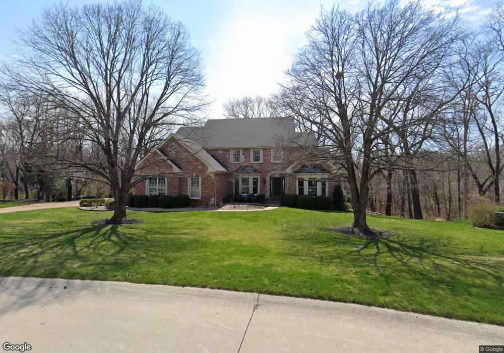
1810 Parsonage Dr Chesterfield, MO 63005
Estimated Value: $890,000 - $946,000
4
Beds
5
Baths
4,072
Sq Ft
$226/Sq Ft
Est. Value
About This Home
This home is located at 1810 Parsonage Dr, Chesterfield, MO 63005 and is currently estimated at $919,812, approximately $225 per square foot. 1810 Parsonage Dr is a home located in St. Louis County with nearby schools including Kehrs Mill Elementary, Crestview Middle School, and Marquette Sr. High School.
Ownership History
Date
Name
Owned For
Owner Type
Purchase Details
Closed on
Sep 11, 2009
Sold by
Davis Mary Lucille
Bought by
Puljak Stephen and Puljak Stephanie
Current Estimated Value
Home Financials for this Owner
Home Financials are based on the most recent Mortgage that was taken out on this home.
Original Mortgage
$417,000
Outstanding Balance
$272,855
Interest Rate
5.2%
Mortgage Type
New Conventional
Estimated Equity
$646,957
Create a Home Valuation Report for This Property
The Home Valuation Report is an in-depth analysis detailing your home's value as well as a comparison with similar homes in the area
Home Values in the Area
Average Home Value in this Area
Purchase History
| Date | Buyer | Sale Price | Title Company |
|---|---|---|---|
| Puljak Stephen | $582,000 | U S Title |
Source: Public Records
Mortgage History
| Date | Status | Borrower | Loan Amount |
|---|---|---|---|
| Open | Puljak Stephen | $417,000 |
Source: Public Records
Tax History Compared to Growth
Tax History
| Year | Tax Paid | Tax Assessment Tax Assessment Total Assessment is a certain percentage of the fair market value that is determined by local assessors to be the total taxable value of land and additions on the property. | Land | Improvement |
|---|---|---|---|---|
| 2025 | $9,836 | $194,070 | $60,670 | $133,400 |
| 2024 | $9,836 | $138,200 | $30,320 | $107,880 |
| 2023 | $9,580 | $138,200 | $30,320 | $107,880 |
| 2022 | $8,462 | $113,470 | $29,200 | $84,270 |
| 2021 | $8,414 | $113,470 | $29,200 | $84,270 |
| 2020 | $9,844 | $149,570 | $28,180 | $121,390 |
| 2019 | $11,412 | $149,570 | $28,180 | $121,390 |
| 2018 | $8,084 | $99,810 | $30,740 | $69,070 |
| 2017 | $7,902 | $99,810 | $30,740 | $69,070 |
| 2016 | $8,223 | $99,810 | $30,740 | $69,070 |
| 2015 | $8,051 | $99,810 | $30,740 | $69,070 |
| 2014 | $7,851 | $94,750 | $37,370 | $57,380 |
Source: Public Records
Map
Nearby Homes
- 16432 Farmers Mill Ln
- 16434 Wilson Creek Ct
- 2242 Whitney Pointe Dr
- 1255 Walnut Hill Farm Dr
- 409 Griffith Ln
- 1910 Walden Pond Ct
- 375 Griffith Ln
- 16094 Meadow Oak Dr
- 1611 Walpole Dr Unit C
- 1621 Walpole Dr Unit B
- 2 Monarch Trace Ct Unit 108
- 831 Stone Meadow Dr
- 15966 Quiet Oak Rd
- 2202 White Cedar Ct
- 15831 Barons Way Dr
- 2248 Ridgley Woods Dr
- 2239 Samuel Stuart Ct
- 1566 Milbridge Dr Unit 13
- 2130 Willow Way Ct
- 34 Picardy Hill Dr
- 1804 Parsonage Dr
- 1807 Parsonage Dr
- 1822 Parsonage Dr
- 16110 Wilson Manor Dr
- 16119 Wilson Manor Dr
- 16142 Wilson Manor Dr
- 2001 Andraes Ln
- 16127 Wilson Manor Dr
- 1 Wheatley Ct
- 1835 Elmsford Ln
- 16102 Wilson Manor Dr
- 16135 Wilson Manor Dr
- 16150 Wilson Manor Dr
- 7 Wheatley Ct
- 1829 Elmsford Ln
- 2009 Andraes Ln
- 16143 Wilson Manor Dr
- 6 Wheatley Ct
- 2000 Andraes Ln
- 1823 Elmsford Ln