
1810 Rifle Range St Roseburg, OR 97470
Estimated payment $4,129/month
Highlights
- RV Access or Parking
- 10.64 Acre Lot
- Wood Burning Stove
- View of Trees or Woods
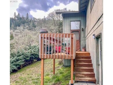
- Deck
- Hilly Lot
About This Home
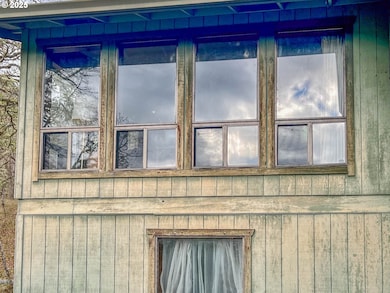
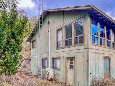
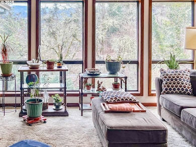
Three bed, three bath home situated in the valley, five minutes from Downtown. Home features beautiful views of the valley, frequent wildlife visits, and the woods behind for hiking enthusiasts. Well is shared with neighbor. There are some foundation issues.

Home Details
Home Type
- Single Family
Est. Annual Taxes
- $2,112
Year Built
- Built in 1978
Lot Details
- 10.64 Acre Lot
- Property fronts a private road
- Private Lot
- Sloped Lot
- Hilly Lot
- Wooded Lot
- Landscaped with Trees
- Property is zoned FF
Parking
- 3 Car Attached Garage
- Garage Door Opener
- Driveway
- RV Access or Parking
Property Views
- Woods
- Seasonal
- Territorial
Home Design
- Slab Foundation
- Composition Roof
- Plywood Siding Panel T1-11
- Concrete Perimeter Foundation
Interior Spaces
- 2,784 Sq Ft Home
- 2-Story Property
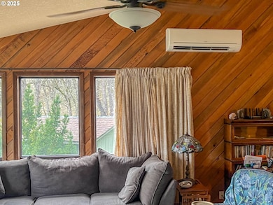
- Vaulted Ceiling
- Ceiling Fan
- Wood Burning Stove
- Wood Burning Fireplace
- Double Pane Windows
- Aluminum Window Frames
- Family Room
- Living Room
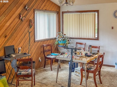
- Dining Room
Kitchen
- Built-In Range
- Indoor Grill
- Range Hood
- Dishwasher
- Disposal
Flooring
- Wall to Wall Carpet
- Concrete
Bedrooms and Bathrooms
- 3 Bedrooms
Outdoor Features
- Deck
- Outbuilding
- Porch
Schools
- Eastwood Elementary School
- Joseph Lane Middle School
- Roseburg High School
Utilities
- Mini Split Air Conditioners
- Heating System Uses Wood
- Radiant Heating System
- Shared Well
- Electric Water Heater
- Septic Tank
- High Speed Internet
Community Details
- No Home Owners Association
Listing and Financial Details
- Assessor Parcel Number R65771
Map
Home Values in the Area
Average Home Value in this Area
Tax History
| Year | Tax Paid | Tax Assessment Tax Assessment Total Assessment is a certain percentage of the fair market value that is determined by local assessors to be the total taxable value of land and additions on the property. | Land | Improvement |
|---|---|---|---|---|
| 2024 | $2,112 | $330,491 | -- | -- |
| 2023 | $2,052 | $320,866 | $0 | $0 |
| 2022 | $1,995 | $311,521 | $0 | $0 |
| 2021 | $1,938 | $302,448 | $0 | $0 |
| 2020 | $1,994 | $293,639 | $0 | $0 |
| 2019 | $1,969 | $285,087 | $0 | $0 |
| 2018 | $1,929 | $276,784 | $0 | $0 |
| 2017 | $1,874 | $268,723 | $0 | $0 |
| 2016 | $1,804 | $260,897 | $0 | $0 |
| 2015 | $1,779 | $253,299 | $0 | $0 |
| 2014 | $1,770 | $250,855 | $0 | $0 |
| 2013 | -- | $243,549 | $0 | $0 |
Property History
| Date | Event | Price | List to Sale | Price per Sq Ft |
|---|---|---|---|---|
| 01/28/2025 01/28/25 | For Sale | $750,000 | -- | $269 / Sq Ft |
Source: Regional Multiple Listing Service (RMLS)
MLS Number: 498340821
APN: R65771
Disclaimer: Certain information contained herein is derived from information provided by parties other than Homes.com. All information provided is deemed reliable, but is not guaranteed to be accurate and should be independently verified.
![]() The content relating to real estate for sale on this web site comes in part from the IDX program of the RMLS™ of Portland, Oregon. Real estate listings held by brokerage firms other than Ten-X are marked with the RMLS™ logo, and detailed information about these properties includes the names of the listing brokers. Listing content is copyright © 2025 RMLS™, Portland, Oregon. Some properties which appear for sale on this web site may subsequently have sold or may no longer be available. All information provided is deemed reliable but is not guaranteed and should be independently verified.
The content relating to real estate for sale on this web site comes in part from the IDX program of the RMLS™ of Portland, Oregon. Real estate listings held by brokerage firms other than Ten-X are marked with the RMLS™ logo, and detailed information about these properties includes the names of the listing brokers. Listing content is copyright © 2025 RMLS™, Portland, Oregon. Some properties which appear for sale on this web site may subsequently have sold or may no longer be available. All information provided is deemed reliable but is not guaranteed and should be independently verified.
- 1745 Rifle Range Rd
- 1763 NE Rocky Dr
- 1744 NE Shale Ct
- 1556 NE Kennedy Loop Dr
- 1710 NE Reagan Dr
- 1734 NE Shale Ct
- 1592 NE Rocky Dr
- 0 NE Rocky Dr Unit 24990635
- 0 NE Rocky Dr Unit 799379173
- 0 NE Rocky Dr Unit 4400 20539110
- 157 NE Spencer Ct
- 675 NE Cummins St
- 207 NE Spencer Ct
- 1650 NE Winter St
- 625 NE Cummins St
- 2978 NE Privado Ct
- 2152 NE Klamath Ave
- 1628 NE Taylor St
- 0 NE Cummins St
- 0 NE Casper St