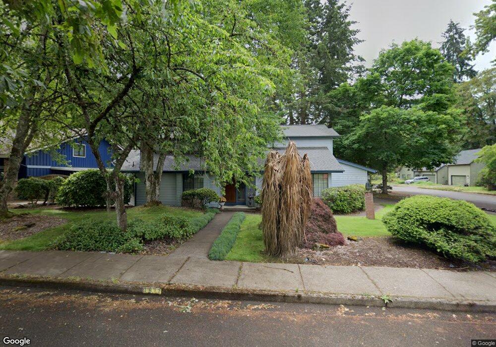
1811 Russet Dr Eugene, OR 97401
Cal Young NeighborhoodEstimated Value: $671,084 - $694,000
3
Beds
3
Baths
2,304
Sq Ft
$297/Sq Ft
Est. Value
About This Home
This home is located at 1811 Russet Dr, Eugene, OR 97401 and is currently estimated at $683,521, approximately $296 per square foot. 1811 Russet Dr is a home located in Lane County with nearby schools including Willagillespie Elementary School, Cal Young Middle School, and Sheldon High School.
Ownership History
Date
Name
Owned For
Owner Type
Purchase Details
Closed on
Oct 16, 2023
Sold by
Sifuentez Eduardo R
Bought by
Sifuentez Joint Trust and Sifuentez
Current Estimated Value
Purchase Details
Closed on
Aug 21, 2003
Sold by
Benfer Larry M and Benfer Rita A
Bought by
Sifuentez Eduardo R and Sifuentez Angelina A
Home Financials for this Owner
Home Financials are based on the most recent Mortgage that was taken out on this home.
Original Mortgage
$180,500
Interest Rate
5.6%
Mortgage Type
Purchase Money Mortgage
Create a Home Valuation Report for This Property
The Home Valuation Report is an in-depth analysis detailing your home's value as well as a comparison with similar homes in the area
Home Values in the Area
Average Home Value in this Area
Purchase History
| Date | Buyer | Sale Price | Title Company |
|---|---|---|---|
| Sifuentez Joint Trust | -- | None Listed On Document | |
| Sifuentez Eduardo R | $265,000 | Western Pioneer Title Co |
Source: Public Records
Mortgage History
| Date | Status | Borrower | Loan Amount |
|---|---|---|---|
| Previous Owner | Sifuentez Eduardo R | $180,500 |
Source: Public Records
Tax History
| Year | Tax Paid | Tax Assessment Tax Assessment Total Assessment is a certain percentage of the fair market value that is determined by local assessors to be the total taxable value of land and additions on the property. | Land | Improvement |
|---|---|---|---|---|
| 2025 | $8,194 | $420,555 | -- | -- |
| 2024 | $8,092 | $408,306 | -- | -- |
| 2023 | $8,092 | $396,414 | $0 | $0 |
| 2022 | $7,581 | $384,868 | $0 | $0 |
| 2021 | $7,074 | $373,659 | $0 | $0 |
| 2020 | $6,936 | $362,776 | $0 | $0 |
| 2019 | $6,597 | $352,210 | $0 | $0 |
| 2018 | $6,194 | $331,992 | $0 | $0 |
| 2017 | $5,850 | $331,992 | $0 | $0 |
| 2016 | $5,667 | $322,322 | $0 | $0 |
| 2015 | $5,481 | $312,934 | $0 | $0 |
| 2014 | $5,306 | $303,819 | $0 | $0 |
Source: Public Records
Map
Nearby Homes
- 1810 Happy Ln
- 2281 Ridgeway Dr
- 1332 Jeppesen Ave
- 0 Piper Ln Unit Lot 1
- 0 Piper Ln Unit Lot 3
- 0 Piper Ln Unit Lot 2
- 0 Piper Ln Unit Lot 5
- 1165 Skylark Ln
- 1193 Rio Glen Dr
- 1500 Norkenzie Rd Unit 12
- 1500 Norkenzie Rd Unit 43
- 2128 Sparrow Ct
- 1328 Spyglass Dr
- 1376 Brickley Rd
- 2280 Tabor St
- 1230 Debrick Rd
- 0 Butte Ln
- 410 Spyglass Dr
- 0 Crenshaw Rd Unit 740506614
- 2101 Lake Isle Ct
Your Personal Tour Guide
Ask me questions while you tour the home.