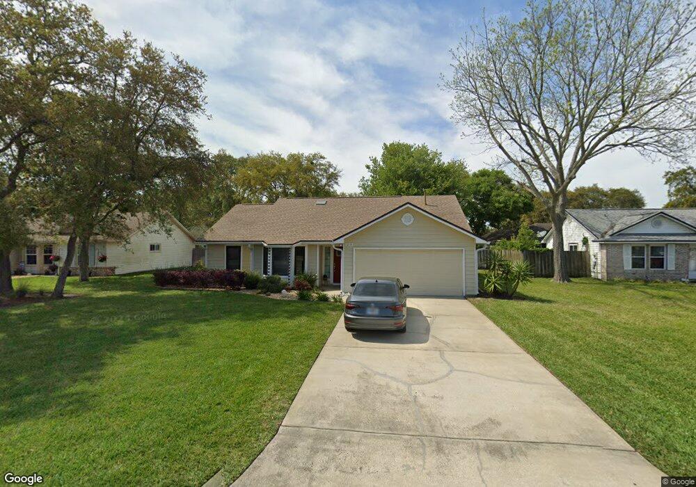
1813 Sterling Ln Fernandina Beach, FL 32034
Estimated Value: $498,000 - $588,000
3
Beds
2
Baths
1,435
Sq Ft
$383/Sq Ft
Est. Value
About This Home
This home is located at 1813 Sterling Ln, Fernandina Beach, FL 32034 and is currently estimated at $549,718, approximately $383 per square foot. 1813 Sterling Ln is a home located in Nassau County with nearby schools including Southside Elementary School, Emma Love Hardee Elementary School, and Fernandina Beach Middle School.
Ownership History
Date
Name
Owned For
Owner Type
Purchase Details
Closed on
Dec 17, 2024
Sold by
Dionne Russell R and Dionne Joanne M
Bought by
Dionne Matthew R and Ford Nicole D
Current Estimated Value
Purchase Details
Closed on
May 18, 2017
Sold by
Seabrooke Gregory L and Seabrooke Nancy B
Bought by
Dionne Russell R and Dionne Joanne M
Home Financials for this Owner
Home Financials are based on the most recent Mortgage that was taken out on this home.
Original Mortgage
$256,500
Interest Rate
4.1%
Mortgage Type
New Conventional
Create a Home Valuation Report for This Property
The Home Valuation Report is an in-depth analysis detailing your home's value as well as a comparison with similar homes in the area
Home Values in the Area
Average Home Value in this Area
Purchase History
| Date | Buyer | Sale Price | Title Company |
|---|---|---|---|
| Dionne Matthew R | $100 | None Listed On Document | |
| Dionne Matthew R | $100 | None Listed On Document | |
| Dionne Russell R | $270,000 | Attorney |
Source: Public Records
Mortgage History
| Date | Status | Borrower | Loan Amount |
|---|---|---|---|
| Previous Owner | Dionne Russell R | $256,500 |
Source: Public Records
Tax History Compared to Growth
Tax History
| Year | Tax Paid | Tax Assessment Tax Assessment Total Assessment is a certain percentage of the fair market value that is determined by local assessors to be the total taxable value of land and additions on the property. | Land | Improvement |
|---|---|---|---|---|
| 2024 | $3,131 | $240,657 | -- | -- |
| 2023 | $3,131 | $233,648 | $0 | $0 |
| 2022 | $2,836 | $226,843 | $0 | $0 |
| 2021 | $2,863 | $220,236 | $0 | $0 |
| 2020 | $2,856 | $217,195 | $90,000 | $127,195 |
| 2019 | $2,822 | $212,813 | $0 | $0 |
| 2018 | $2,792 | $208,845 | $0 | $0 |
| 2017 | $2,692 | $174,943 | $0 | $0 |
| 2016 | $2,676 | $168,208 | $0 | $0 |
| 2015 | $2,427 | $152,916 | $0 | $0 |
| 2014 | $2,241 | $140,439 | $0 | $0 |
Source: Public Records
Map
Nearby Homes
- 1918 Sea Oats Ave
- 2133 Taurus Ct
- 96025 Sea Breeze Way
- 1401 Fountain Dr
- 2105 Purcell Dr
- 96147 Montego Bay
- 2881 Landyns Cir
- 884 Robinhood Dr
- 2552 Pirates Bay Dr
- 2490 Captain Hook Dr
- 2674 Robert Oliver Ave
- 1512 Inverness Rd Unit 3
- 2700 Mizell Ave Unit 203B
- 2700 Mizell Ave Unit 504A
- 2700 Mizell Ave Unit 403A
- 2583 Forest Ridge Dr Unit 3
- 2563 Forest Ridge Dr Unit P3
- 2696 Forest Ridge Dr Unit A6
- 2588 Forest Ridge Dr Unit N-8
- 1984 Amelia Green
- 1805 Sterling Ln
- 1819 Sterling Ln
- 1724 Laser Ct
- 1814 Laser Ct
- 1827 Sterling Ln
- 1812 Sterling Ln
- 1804 Sterling Ln
- 1820 Sterling Ln
- 1818 Laser Ct
- 1726 Sterling Ln
- 2713 Delorean St
- 2721 Delorean St
- 1828 Sterling Ln
- 2705 Benz Place
- 2705 Delorean St
- 2685 Benz Place
- 2729 Sterling Ct
- 1811 Laser Ct
- 2614 Delorean St
- 2683 Delorean St