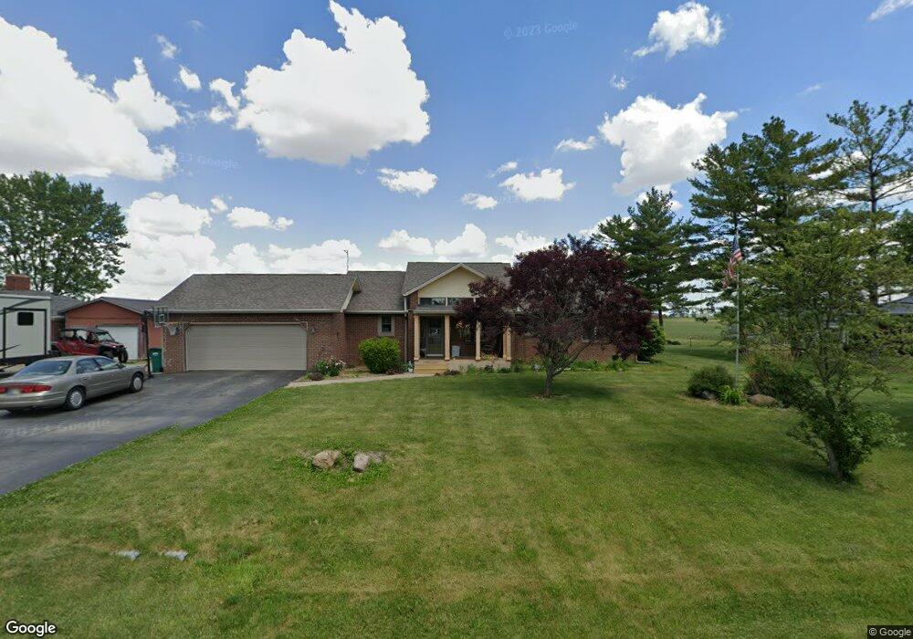
1815 John Bart Rd Lebanon, IN 46052
Estimated Value: $319,000 - $372,000
3
Beds
2
Baths
1,550
Sq Ft
$221/Sq Ft
Est. Value
About This Home
This home is located at 1815 John Bart Rd, Lebanon, IN 46052 and is currently estimated at $342,248, approximately $220 per square foot. 1815 John Bart Rd is a home located in Boone County with nearby schools including Central Elementary School, Lebanon Middle School, and Lebanon Senior High School.
Ownership History
Date
Name
Owned For
Owner Type
Purchase Details
Closed on
Apr 28, 2006
Sold by
Vinson Harold
Bought by
Reynolds Richard A and Reynolds Jennifer J
Current Estimated Value
Home Financials for this Owner
Home Financials are based on the most recent Mortgage that was taken out on this home.
Original Mortgage
$110,000
Outstanding Balance
$63,671
Interest Rate
6.39%
Mortgage Type
New Conventional
Estimated Equity
$278,577
Create a Home Valuation Report for This Property
The Home Valuation Report is an in-depth analysis detailing your home's value as well as a comparison with similar homes in the area
Home Values in the Area
Average Home Value in this Area
Purchase History
| Date | Buyer | Sale Price | Title Company |
|---|---|---|---|
| Reynolds Richard A | -- | -- |
Source: Public Records
Mortgage History
| Date | Status | Borrower | Loan Amount |
|---|---|---|---|
| Open | Reynolds Richard A | $110,000 |
Source: Public Records
Tax History Compared to Growth
Tax History
| Year | Tax Paid | Tax Assessment Tax Assessment Total Assessment is a certain percentage of the fair market value that is determined by local assessors to be the total taxable value of land and additions on the property. | Land | Improvement |
|---|---|---|---|---|
| 2024 | $2,145 | $289,100 | $17,200 | $271,900 |
| 2023 | $2,043 | $277,000 | $17,200 | $259,800 |
| 2022 | $1,905 | $251,600 | $17,200 | $234,400 |
| 2021 | $1,664 | $215,600 | $17,200 | $198,400 |
| 2020 | $1,512 | $201,500 | $17,200 | $184,300 |
| 2019 | $1,385 | $199,000 | $17,200 | $181,800 |
| 2018 | $1,342 | $180,600 | $17,200 | $163,400 |
| 2017 | $1,188 | $169,400 | $17,200 | $152,200 |
| 2016 | $1,183 | $161,200 | $17,200 | $144,000 |
| 2014 | $1,083 | $153,700 | $19,100 | $134,600 |
| 2013 | $1,057 | $153,700 | $19,100 | $134,600 |
Source: Public Records
Map
Nearby Homes
- 2018 Elizaville Rd
- 1919 Elizaville Rd
- 1903 Elizaville Rd
- 1116 Sunnyside Ln
- 2215 Golfside Dr
- Chatham Plan at Angilee Gardens
- Cortland Plan at Angilee Gardens
- Stamford Plan at Angilee Gardens
- Dayton Plan at Angilee Gardens
- Fairfax Plan at Angilee Gardens
- Johnstown Plan at Angilee Gardens
- Henley Plan at Angilee Gardens
- 920 Angilee Way
- 2305 Golfside Dr
- 916 Angilee Way
- 914 Angilee Way
- 912 Angilee Way
- Breckenridge Plan at Cedar Ridge - Maple Street Collection
- Jensen Plan at Cedar Ridge - Maple Street Collection
- Yosemite Plan at Cedar Ridge - Maple Street Collection
- 1815 John-Bart Rd
- 1825 John Bart Rd
- 1775 John Bart Rd
- 1820 John Bart Rd
- 1855 John Bart Rd
- 1850 John Bart Rd
- 1855 John-Bart Rd
- 1755 John-Bart Rd
- 1755 John Bart Rd
- 1895 John Bart Rd
- 1735 John Bart Rd
- 1890 John Bart Rd
- 1925 John Bart Rd
- 1920 John Bart Rd
- 1715 John Bart Rd
- 1955 John Bart Rd
- 1950 John Bart Rd
- 1695 John Bart Rd
- 1680 John Bart Rd
- 1975 John Bart Rd